National Register of Historic Places listings in Hidalgo County, New Mexico
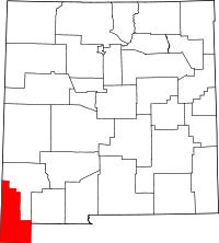
Location of Hidalgo County in New Mexico
This is a list of the National Register of Historic Places listings in Hidalgo County, New Mexico.
This is intended to be a complete list of the properties and districts on the National Register of Historic Places in Hidalgo County, New Mexico, United States. Latitude and longitude coordinates are provided for many National Register properties and districts; these locations may be seen together in a map.[1]
There are 25 properties and districts listed on the National Register in the county. Another property was once listed but has been removed. All of the places within the county on the National Register are also listed on the State Register of Cultural Properties.
- This National Park Service list is complete through NPS recent listings posted December 2, 2016.[2]
| Bernalillo – Catron – Chaves – Cibola – Colfax – Curry – De Baca – Doña Ana – Eddy – Grant – Guadalupe – Harding – Hidalgo – Lea – Lincoln – Los Alamos – Luna – McKinley – Mora – Otero – Quay – Rio Arriba – Roosevelt – San Juan – San Miguel – Sandoval – Santa Fe – Sierra – Socorro – Taos – Torrance – Union – Valencia |
Current listings
| [3] | Name on the Register[4] | Image | Date listed[5] | Location | City or town | Description |
|---|---|---|---|---|---|---|
| 1 | Alamo Hueco Site |  |
(#92001800) |
Address Restricted |
Animas | In the Alamo Hueco Mountains |
| 2 | Archeological Site No. LA 54021 | |
(#92001802) |
Address Restricted |
Animas | |
| 3 | Archeological Site No. LA 54042 | |
(#92001811) |
Address Restricted |
Animas | |
| 4 | Archeological Site No. LA 54049 | |
(#92001813) |
Address Restricted |
Animas | |
| 5 | Archeological Site No. LA 54050 | |
(#92001814) |
Address Restricted |
Animas | |
| 6 | Box Canyon Site | |
(#92001796) |
Address Restricted |
Animas | |
| 7 | Brushy Creek Ruin | |
(#92001815) |
Address Restricted |
Animas | |
| 8 | Clanton Draw Site | |
(#92001795) |
Address Restricted |
Animas | |
| 9 | Culberson Ruin | |
(#92001799) |
Address Restricted |
Animas | |
| 10 | Double Adobe Creek Site | |
(#92001807) |
Address Restricted |
Animas | |
| 11 | Fortress-Stewart Ranch Site | |
(#92001803) |
Address Restricted |
Animas | |
| 12 | Hidalgo County Courthouse | 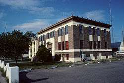 |
(#87000897) |
300 S. Shakespeare St. 32°20′52″N 108°42′26″W / 32.347778°N 108.707222°W |
Lordsburg | |
| 13 | Hoskins Site | |
(#92001804) |
Address Restricted |
Animas | |
| 14 | Joyce Well Site | |
(#92001798) |
Address Restricted |
Animas | |
| 15 | Little Site | |
(#92001805) |
Address Restricted |
Animas | |
| 16 | Lordsburg-Hidalgo County Library | |
(#03001547) |
208 E. 3rd St. 32°20′53″N 108°42′28″W / 32.34811°N 108.70764°W |
Lordsburg | |
| 17 | Lordsburg High School | |
(#15000606) |
209 Penn St. 32°20′59″N 108°42′42″W / 32.349778°N 108.711706°W |
Lordsburg | The old high school building. |
| 18 | Lunch Box Site | |
(#92001801) |
Address Restricted |
Animas | |
| 19 | Metate Ruin | |
(#92001812) |
Address Restricted |
Animas | |
| 20 | Pendleton Ruin | |
(#92001794) |
Address Restricted |
Animas | |
| 21 | Pigpen Creek Site | |
(#92001806) |
Address Restricted |
Animas | |
| 22 | Saddle Bronc-Battleground Site | |
(#92001810) |
Address Restricted |
Animas | |
| 23 | Shakespeare Ghost Town | 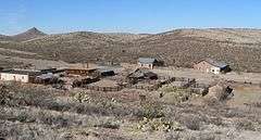 |
(#73001141) |
Southwest of Lordsburg, off State Road 494 32°19′32″N 108°44′18″W / 32.32556°N 108.73833°W |
Lordsburg | |
| 24 | Sycamore Well Site | |
(#92001797) |
Address Restricted |
Animas | |
| 25 | Timberlake Ruin-Walnut Creek Site | |
(#92001809) |
Address Restricted |
Animas |
Former listing
| [3] | Name on the Register | Image | Date listed | Date removed | Location | City or town | Summary |
|---|---|---|---|---|---|---|---|
| 1 | Cloverdale Park Site | Upload image | (#92001808) | Address Restricted |
Animas |
See also
| Wikimedia Commons has media related to National Register of Historic Places in Hidalgo County, New Mexico. |
- List of National Historic Landmarks in New Mexico
- National Register of Historic Places listings in New Mexico
References
- ↑ The latitude and longitude information provided in this table was derived originally from the National Register Information System, which has been found to be fairly accurate for about 99% of listings. For about 1% of NRIS original coordinates, experience has shown that one or both coordinates are typos or otherwise extremely far off; some corrections may have been made. A more subtle problem causes many locations to be off by up to 150 yards, depending on location in the country: most NRIS coordinates were derived from tracing out latitude and longitudes off of USGS topographical quadrant maps created under the North American Datum of 1927, which differs from the current, highly accurate WGS84 GPS system used by most on-line maps. Chicago is about right, but NRIS longitudes in Washington are higher by about 4.5 seconds, and are lower by about 2.0 seconds in Maine. Latitudes differ by about 1.0 second in Florida. Some locations in this table may have been corrected to current GPS standards.
- ↑ "National Register of Historic Places: Weekly List Actions". National Park Service, United States Department of the Interior. Retrieved on December 2, 2016.
- 1 2 Numbers represent an ordering by significant words. Various colorings, defined here, differentiate National Historic Landmarks and historic districts from other NRHP buildings, structures, sites or objects.
- ↑ National Park Service (2008-04-24). "National Register Information System". National Register of Historic Places. National Park Service.
- ↑ The eight-digit number below each date is the number assigned to each location in the National Register Information System database, which can be viewed by clicking the number.
| Topics | |
|---|---|
| Lists by states |
|
| Lists by insular areas | |
| Lists by associated states | |
| Other areas | |
| |
Municipalities and communities of Hidalgo County, New Mexico, United States | ||
|---|---|---|
| City | | |
| Village | ||
| CDPs | ||
| Other unincorporated communities | ||
| Ghost towns |
| |
This article is issued from Wikipedia - version of the 12/2/2016. The text is available under the Creative Commons Attribution/Share Alike but additional terms may apply for the media files.