National Register of Historic Places listings in White County, Tennessee
Location of White County in Tennessee
This is a list of the National Register of Historic Places listings in White County, Tennessee.
This is intended to be a complete list of the properties and districts on the National Register of Historic Places in White County, Tennessee, United States. Latitude and longitude coordinates are provided for many National Register properties and districts; these locations may be seen together in a map.[1]
There are 12 properties and districts listed on the National Register in the county.
| Anderson – Bedford – Benton – Bledsoe – Blount – Bradley – Campbell – Cannon – Carroll – Carter – Cheatham – Chester – Claiborne – Clay – Cocke – Coffee – Crockett – Cumberland – Davidson – Decatur – DeKalb – Dickson – Dyer – Fayette – Fentress – Franklin – Gibson – Giles – Grainger – Greene – Grundy – Hamblen – Hamilton – Hancock – Hardeman – Hardin – Hawkins – Haywood – Henderson – Henry – Hickman – Houston – Humphreys – Jackson – Jefferson – Johnson – Knox – Lake – Lauderdale – Lawrence – Lewis – Lincoln – Loudon – Macon – Madison – Marion – Marshall – Maury – McMinn – McNairy – Meigs – Monroe – Montgomery – Moore – Morgan – Obion – Overton – Perry – Pickett – Polk – Putnam – Rhea – Roane – Robertson – Rutherford – Scott – Sequatchie – Sevier – Shelby – Smith – Stewart – Sullivan – Sumner – Tipton – Trousdale – Unicoi – Union – Van Buren – Warren – Washington – Wayne – Weakley – White – Williamson – Wilson |
- This National Park Service list is complete through NPS recent listings posted December 2, 2016.[2]
Current listings
| [3] | Name on the Register[4] | Image | Date listed[5] | Location | City or town | Description |
|---|---|---|---|---|---|---|
| 1 | Cherry Creek Mound | Upload image | (#78002648) |
Address Restricted |
Key | |
| 2 | Community Building | 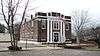 |
(#02000085) |
5 W. Maple St. 35°55′30″N 85°27′53″W / 35.925°N 85.464722°W |
Sparta | Now known as "Liberty Hall," home to an American Legion order |
| 3 | Great Falls Hydroelectric Station | 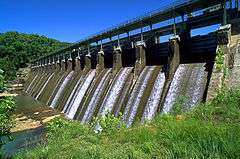 |
(#90001004) |
Off U.S. Route 70 at mile 91.1 on the Caney Fork 35°48′07″N 85°37′19″W / 35.801944°N 85.621944°W |
Rock Island | Extends into Warren County |
| 4 | Indian Cave Petroglyphs | Upload image | (#78002649) |
Address Restricted |
Onward | |
| 5 | Nashville, Chattanooga and St. Louis Railway Section House | 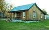 |
(#11000421) |
9479 Crossville Hwy. 35°57′03″N 85°18′30″W / 35.950833°N 85.308333°W |
DeRossett | 1900s-era railroad section house; now home to the Bon Air Historical Society Museum |
| 6 | Ravencroft Mine | Upload image | (#15000449) |
Glade Creek Rd. Coordinates missing |
Sparta vicinity | |
| 7 | Sparta Electric Building | 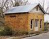 |
(#93000238) |
S. Main St. 35°55′26″N 85°27′55″W / 35.923889°N 85.465278°W |
Sparta | Located at the corner of S. Main and Young streets |
| 8 | Sparta Hydroelectric Station | Upload image | (#90000306) |
State Route 111 at the Calfkiller River 35°54′45″N 85°28′34″W / 35.9125°N 85.476111°W |
Sparta | |
| 9 | Sparta Nashville, Chattanooga and St. Louis Railroad Depot | 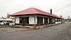 |
(#92001658) |
Junction of Depot and Clark Sts. 35°56′14″N 85°28′18″W / 35.937222°N 85.471667°W |
Sparta | |
| 10 | Sparta Residential Historic District | 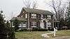 |
(#91001586) |
Roughly bounded by N. Main, College, Everett, and Church Sts. 35°55′43″N 85°27′49″W / 35.928611°N 85.463611°W |
Sparta | |
| 11 | Sparta Rock House | 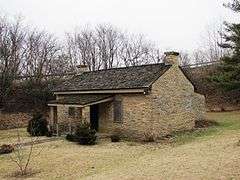 |
(#73001856) |
3 miles east of Sparta on U.S. Route 70 35°55′13″N 85°24′13″W / 35.920278°N 85.403611°W |
Sparta | Mid-19th century toll house and stagecoach stop; maintained as a state historic site |
| 12 | Sperry-Smith House | 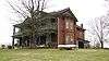 |
(#96001357) |
121 E. Maple St. 35°55′28″N 85°27′42″W / 35.924444°N 85.461667°W |
Sparta |
Former listings
| [3] | Name on the Register | Image | Date listed | Date removed | Location | City or town | Summary |
|---|---|---|---|---|---|---|---|
| 1 | Jessee Lincoln House | .tif.jpg) |
(#73002244) | W of Sparta on TN 26 |
Sparta | ||
| 2 | Oldham Theater |  |
(#93001188) | W. Liberty Square |
Sparta |
See also
| Wikimedia Commons has media related to National Register of Historic Places in White County, Tennessee. |
- List of National Historic Landmarks in Tennessee
- National Register of Historic Places listings in Tennessee
References
- ↑ The latitude and longitude information provided in this table was derived originally from the National Register Information System, which has been found to be fairly accurate for about 99% of listings. For about 1% of NRIS original coordinates, experience has shown that one or both coordinates are typos or otherwise extremely far off; some corrections may have been made. A more subtle problem causes many locations to be off by up to 150 yards, depending on location in the country: most NRIS coordinates were derived from tracing out latitude and longitudes off of USGS topographical quadrant maps created under the North American Datum of 1927, which differs from the current, highly accurate WGS84 GPS system used by most on-line maps. Chicago is about right, but NRIS longitudes in Washington are higher by about 4.5 seconds, and are lower by about 2.0 seconds in Maine. Latitudes differ by about 1.0 second in Florida. Some locations in this table may have been corrected to current GPS standards.
- ↑ "National Register of Historic Places: Weekly List Actions". National Park Service, United States Department of the Interior. Retrieved on December 2, 2016.
- 1 2 Numbers represent an ordering by significant words. Various colorings, defined here, differentiate National Historic Landmarks and historic districts from other NRHP buildings, structures, sites or objects.
- ↑ National Park Service (2008-04-24). "National Register Information System". National Register of Historic Places. National Park Service.
- ↑ The eight-digit number below each date is the number assigned to each location in the National Register Information System database, which can be viewed by clicking the number.
| Topics | |
|---|---|
| Lists by states |
|
| Lists by insular areas | |
| Lists by associated states | |
| Other areas | |
| |
Municipalities and communities of White County, Tennessee, United States | ||
|---|---|---|
| City | ||
| Town | ||
| Unincorporated communities | ||
This article is issued from Wikipedia - version of the 6/11/2016. The text is available under the Creative Commons Attribution/Share Alike but additional terms may apply for the media files.