Natoma, Kansas
| Natoma, Kansas | |
|---|---|
| City | |
|
Facing southwest, as the tracks and the streets were perpendicular to the tracks (2014) | |
 Location within Osborne County and Kansas | |
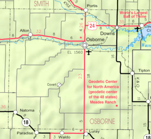 KDOT map of Osborne County (legend) | |
| Coordinates: 39°11′21″N 99°1′29″W / 39.18917°N 99.02472°WCoordinates: 39°11′21″N 99°1′29″W / 39.18917°N 99.02472°W | |
| Country | United States |
| State | Kansas |
| County | Osborne |
| Founded | 1888 |
| Incorporated | 1905 |
| Government | |
| • Type | Mayor–Council |
| Area[1] | |
| • Total | 0.41 sq mi (1.06 km2) |
| • Land | 0.41 sq mi (1.06 km2) |
| • Water | 0 sq mi (0 km2) |
| Elevation | 1,834 ft (559 m) |
| Population (2010)[2] | |
| • Total | 335 |
| • Estimate (2015)[3] | 316 |
| • Density | 820/sq mi (320/km2) |
| Time zone | Central (CST) (UTC-6) |
| • Summer (DST) | CDT (UTC-5) |
| ZIP code | 67651 |
| Area code | 785 |
| FIPS code | 20-49425 [4] |
| GNIS feature ID | 0472448 [5] |
| Website | cityofnatoma.com |

Natoma is a city in Osborne County, Kansas, United States.[5] As of the 2010 census, the city population was 335.[6]
History
Natoma was established in 1888, named after an American Indian railroad employee by a railroad officer. The name means "new born."[7] The first post office had opened under the name Tapley in December 1878, but changed its name to Natoma in July 1890.[8] Natoma incorporated as a city in 1905.[9]
Geography
Natoma is located at 39°11′21″N 99°1′29″W / 39.18917°N 99.02472°W (39.189054, -99.024832)[10] at an elevation of 1,834 feet (559 m).[5] It lies in the Smoky Hills region of the Great Plains approximately 9 miles (14 km) north of the Saline River.[11][12] Paradise Creek, a tributary of the Saline, flows southeast along the southern edge of the city.[12] Natoma is in north-central Kansas approximately 135 miles (217 km) northwest of Wichita and 230 miles (370 km) west of Kansas City.[13] Located on K-18, it is roughly 25 miles (40 km) southwest of Osborne, the county seat.[12]
According to the United States Census Bureau, the city has a total area of 0.41 square miles (1.06 km2), all of it land.[1]
Demographics
| Historical population | |||
|---|---|---|---|
| Census | Pop. | %± | |
| 1910 | 407 | — | |
| 1920 | 518 | 27.3% | |
| 1930 | 583 | 12.5% | |
| 1940 | 651 | 11.7% | |
| 1950 | 775 | 19.0% | |
| 1960 | 775 | 0.0% | |
| 1970 | 603 | −22.2% | |
| 1980 | 515 | −14.6% | |
| 1990 | 392 | −23.9% | |
| 2000 | 367 | −6.4% | |
| 2010 | 335 | −8.7% | |
| Est. 2015 | 316 | [3] | −5.7% |
| U.S. Decennial Census | |||
2010 census
As of the census[2] of 2010, there were 335 people, 160 households, and 86 families residing in the city. The population density was 817.1 inhabitants per square mile (315.5/km2). There were 229 housing units at an average density of 558.5 per square mile (215.6/km2). The racial makeup of the city was 97.0% White, 0.9% African American, 1.2% Asian, and 0.9% from two or more races. Hispanic or Latino of any race were 2.1% of the population.
There were 160 households of which 25.6% had children under the age of 18 living with them, 40.0% were married couples living together, 8.8% had a female householder with no husband present, 5.0% had a male householder with no wife present, and 46.3% were non-families. 43.1% of all households were made up of individuals and 18.8% had someone living alone who was 65 years of age or older. The average household size was 2.09 and the average family size was 2.86.
The median age in the city was 43.5 years. 23.3% of residents were under the age of 18; 6.1% were between the ages of 18 and 24; 23.1% were from 25 to 44; 21.9% were from 45 to 64; and 26% were 65 years of age or older. The gender makeup of the city was 54.9% male and 45.1% female.
2000 census
As of the census[4] of 2000, there were 367 people, 178 households, and 95 families residing in the city. The population density was 874.8 people per square mile (337.4/km²). There were 244 housing units at an average density of 581.6 per square mile (224.3/km²). The racial makeup of the city was 98.91% White, 0.27% Native American, 0.27% Asian, 0.27% from other races, and 0.27% from two or more races. Hispanic or Latino of any race were 1.09% of the population.
There were 178 households out of which 25.3% had children under the age of 18 living with them, 46.1% were married couples living together, 3.4% had a female householder with no husband present, and 46.6% were non-families. 44.4% of all households were made up of individuals and 21.3% had someone living alone who was 65 years of age or older. The average household size was 2.06 and the average family size was 2.88.
In the city the population was spread out with 24.8% under the age of 18, 4.6% from 18 to 24, 25.1% from 25 to 44, 20.7% from 45 to 64, and 24.8% who were 65 years of age or older. The median age was 42 years. For every 100 females there were 105.0 males. For every 100 females age 18 and over, there were 100.0 males.
The median income for a household in the city was $24,091, and the median income for a family was $37,500. Males had a median income of $24,896 versus $22,083 for females. The per capita income for the city was $14,671. About 8.7% of families and 15.9% of the population were below the poverty line, including 13.7% of those under age 18 and 9.6% of those age 65 or over.
Culture
Events
The city holds a Labor Day celebration which serves as its annual community festival and includes a parade, barbecue, and other entertainment.[7]
Points of interest
Natoma Presbyterian Church, constructed in 1899, is listed in the National Register of Historic Places for its architecture.[7]
Education
USD 399 provides public primary and secondary education, operating two schools in the city: Natoma Elementary School (Grades K-6) and Natoma High School (7-12).[14]
Transportation
K-18, an east-west route, approaches Natoma from the west, then turns southeast along the eastern side of the city.[12]
References
- 1 2 "US Gazetteer files 2010". United States Census Bureau. Retrieved 2012-07-06.
- 1 2 "American FactFinder". United States Census Bureau. Retrieved 2012-07-06.
- 1 2 "Annual Estimates of the Resident Population for Incorporated Places: April 1, 2010 to July 1, 2015". Retrieved July 2, 2016.
- 1 2 "American FactFinder". United States Census Bureau. Retrieved 2008-01-31.
- 1 2 3 "US Board on Geographic Names". United States Geological Survey. 2007-10-25. Retrieved 2008-01-31.
- ↑ "2010 City Population and Housing Occupancy Status". U.S. Census Bureau. Retrieved June 14, 2011.
- 1 2 3 "Natoma - Amazing 100 Miles Featured City". The Amazing 100 Miles Tourism Coalition. 2008-11-10. Retrieved 2010-12-20.
- ↑ "Post Offices". Kansas Historical Society. Retrieved 2010-12-20.
- ↑ Blackmar, Frank W., ed. (1912). "Natoma". Kansas: a cyclopedia of state history, embracing events, institutions, industries, counties, cities, towns, prominent persons, etc. 2. Chicago: Standard. p. 336.
- ↑ "US Gazetteer files: 2010, 2000, and 1990". United States Census Bureau. 2011-02-12. Retrieved 2011-04-23.
- ↑ "2003-2004 Official Transportation Map" (PDF). Kansas Department of Transportation. 2003. Retrieved 2010-12-18.
- 1 2 3 4 "General Highway Map - Osborne County, Kansas" (PDF). Kansas Department of Transportation. 1999. Retrieved 2010-12-18.
- ↑ "City Distance Tool". Geobytes. Retrieved 2010-12-18.
- ↑ "USD 399". USD 399. Retrieved 2010-12-20.
External links
| Wikimedia Commons has media related to Natoma, Kansas. |
- City
- Schools
- USD 399, local school district
- Maps
- Natoma City Map, KDOT
Municipalities and communities of Osborne County, Kansas, United States | ||
|---|---|---|
| Cities | 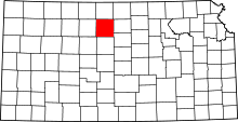 | |
| Unincorporated communities |
| |
| Townships |
| |