New Market, Iowa
| New Market, Iowa | |
|---|---|
| City | |
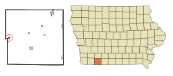 Location of New Market, Iowa | |
| Coordinates: 40°43′49″N 94°54′5″W / 40.73028°N 94.90139°WCoordinates: 40°43′49″N 94°54′5″W / 40.73028°N 94.90139°W | |
| Country |
|
| State |
|
| County | Taylor |
| Area[1] | |
| • Total | 0.44 sq mi (1.14 km2) |
| • Land | 0.44 sq mi (1.14 km2) |
| • Water | 0 sq mi (0 km2) |
| Elevation | 1,234 ft (376 m) |
| Population (2010)[2] | |
| • Total | 415 |
| • Estimate (2012[3]) | 410 |
| • Density | 943.2/sq mi (364.2/km2) |
| Time zone | Central (CST) (UTC-6) |
| • Summer (DST) | CDT (UTC-5) |
| ZIP code | 51646 |
| Area code(s) | 712 |
| FIPS code | 19-56370 |
| GNIS feature ID | 0459481 |
New Market is a city in Taylor County, Iowa, United States. The population was 415 at the 2010 census.
History
New Market had its start in the year 1881 by the building of the Humeston and Shenandoah Railroad through that territory.[4]
Geography
New Market is located at 40°43′49″N 94°54′5″W / 40.73028°N 94.90139°W (40.730414, -94.901423).[5]
According to the United States Census Bureau, the city has a total area of 0.44 square miles (1.14 km2), all of it land.[1]
Demographics
| Historical populations | ||
|---|---|---|
| Year | Pop. | ±% |
| 1890 | 320 | — |
| 1900 | 600 | +87.5% |
| 1910 | 673 | +12.2% |
| 1920 | 745 | +10.7% |
| 1930 | 630 | −15.4% |
| 1940 | 681 | +8.1% |
| 1950 | 573 | −15.9% |
| 1960 | 506 | −11.7% |
| 1970 | 501 | −1.0% |
| 1980 | 554 | +10.6% |
| 1990 | 454 | −18.1% |
| 2000 | 456 | +0.4% |
| 2010 | 415 | −9.0% |
| 2014 | 405 | −2.4% |
| 2015 | 408 | +0.7% |
| Source:"American FactFinder". United States Census Bureau. and Iowa Data Center Source: | ||
2010 census
As of the census[2] of 2010, there were 415 people, 190 households, and 117 families residing in the city. The population density was 943.2 inhabitants per square mile (364.2/km2). There were 212 housing units at an average density of 481.8 per square mile (186.0/km2). The racial makeup of the city was 98.1% White, 0.2% Native American, 0.2% Asian, and 1.4% from two or more races. Hispanic or Latino of any race were 0.2% of the population.
There were 190 households of which 29.5% had children under the age of 18 living with them, 45.8% were married couples living together, 9.5% had a female householder with no husband present, 6.3% had a male householder with no wife present, and 38.4% were non-families. 33.2% of all households were made up of individuals and 14.8% had someone living alone who was 65 years of age or older. The average household size was 2.18 and the average family size was 2.68.
The median age in the city was 41.8 years. 22.9% of residents were under the age of 18; 7.5% were between the ages of 18 and 24; 23.6% were from 25 to 44; 27.2% were from 45 to 64; and 18.8% were 65 years of age or older. The gender makeup of the city was 48.2% male and 51.8% female.
2000 census
As of the census[7] of 2000, there were 456 people, 205 households, and 128 families residing in the city. The population density was 1,038.7 people per square mile (400.1/km²). There were 224 housing units at an average density of 510.2 per square mile (196.6/km²). The racial makeup of the city was 99.34% White, 0.22% Native American and 0.44% Asian. Hispanic or Latino of any race were 0.44% of the population.
There were 205 households out of which 25.9% had children under the age of 18 living with them, 49.8% were married couples living together, 8.3% had a female householder with no husband present, and 37.1% were non-families. 33.2% of all households were made up of individuals and 19.0% had someone living alone who was 65 years of age or older. The average household size was 2.22 and the average family size was 2.74.
In the city the population was spread out with 24.8% under the age of 18, 7.5% from 18 to 24, 26.3% from 25 to 44, 21.5% from 45 to 64, and 20.0% who were 65 years of age or older. The median age was 38 years. For every 100 females there were 95.7 males. For every 100 females age 18 and over, there were 88.5 males.
The median income for a household in the city was $31,771, and the median income for a family was $34,896. Males had a median income of $31,250 versus $25,227 for females. The per capita income for the city was $15,381. About 15.7% of families and 14.2% of the population were below the poverty line, including 17.6% of those under age 18 and 12.8% of those age 65 or over.
Notable person
- Ora Smith, Illinois politician and farmer, was born in New Market.
References
- 1 2 "US Gazetteer files 2010". United States Census Bureau. Retrieved 2012-05-11.
- 1 2 "American FactFinder". United States Census Bureau. Retrieved 2012-05-11.
- ↑ "Population Estimates". United States Census Bureau. Retrieved 2013-05-23.
- ↑ Crosson, Frank E. (1910). History of Taylor County, Iowa: From the Earliest Historic Times to 1910. Walsworth Publishing Company. p. 189.
- ↑ "US Gazetteer files: 2010, 2000, and 1990". United States Census Bureau. 2011-02-12. Retrieved 2011-04-23.
- ↑ "Census of Population and Housing". Census.gov. Retrieved June 4, 2015.
- ↑ "American FactFinder". United States Census Bureau. Retrieved 2008-01-31.
Further reading
- Hartman, Chester. Poverty and Race in America. Lanham: Lexington, 2006.
Municipalities and communities of Taylor County, Iowa, United States | ||
|---|---|---|
| Cities | ||
| Townships | ||
| CDP | ||
| Footnotes | ‡This populated place also has portions in an adjacent county or counties | |