New Shoreham, Rhode Island
| New Shoreham | |
|---|---|
| Town | |
|
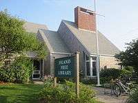
The public library in New Shoreham | |
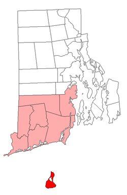 Location of New Shoreham in Washington County, Rhode Island | |
| Coordinates: 41°10′35″N 71°34′48″W / 41.17639°N 71.58000°W | |
| Country | United States |
| State | Rhode Island |
| County | Washington |
| Government | |
| • Town Council |
Allan MacKay Christopher G. Warfel Mark A. Emmanuelle |
| • Town Moderator | Margaret M. O'Neill |
| Area | |
| • Total | 109.5 sq mi (283.6 km2) |
| • Land | 9.7 sq mi (25.2 km2) |
| • Water | 99.8 sq mi (258.4 km2) |
| Elevation | 13 ft (4 m) |
| Population (2000) | |
| • Total | 1,041 |
| • Density | 103.8/sq mi (40.1/km2) |
| Time zone | Eastern (EST) (UTC-5) |
| • Summer (DST) | EDT (UTC-4) |
| ZIP code | 02807 (Block Island) |
| Area code(s) | 401 |
| FIPS code | 44-50500[1] |
| GNIS feature ID | 1220043[2] |
| Website | www.new-shoreham.com |
New Shoreham is a town in Washington County, Rhode Island, United States. The town is coextensive with Block Island. The population was 1,041 at the 2010 census, making it the least-populous municipality in the state. New Shoreham was named for Shoreham, Kent, in England. Historic Harbor Church, founded on October 23, 1765, is located at 21 Water Street in New Shoreham.[3]
Geography
According to the United States Census Bureau, the town has a total area of 109.5 square miles (284 km2), of which, 9.7 square miles (25 km2) of it is land and 99.8 square miles (258 km2) of it (91.11%) is water.
Demographics
| Historical population | |||
|---|---|---|---|
| Census | Pop. | %± | |
| 1790 | 682 | — | |
| 1800 | 714 | 4.7% | |
| 1810 | 722 | 1.1% | |
| 1820 | 955 | 32.3% | |
| 1830 | 1,185 | 24.1% | |
| 1840 | 1,069 | −9.8% | |
| 1850 | 1,262 | 18.1% | |
| 1860 | 1,320 | 4.6% | |
| 1870 | 1,113 | −15.7% | |
| 1880 | 1,203 | 8.1% | |
| 1890 | 1,320 | 9.7% | |
| 1900 | 1,396 | 5.8% | |
| 1910 | 1,314 | −5.9% | |
| 1920 | 1,038 | −21.0% | |
| 1930 | 1,029 | −0.9% | |
| 1940 | 848 | −17.6% | |
| 1950 | 732 | −13.7% | |
| 1960 | 486 | −33.6% | |
| 1970 | 489 | 0.6% | |
| 1980 | 620 | 26.8% | |
| 1990 | 836 | 34.8% | |
| 2000 | 1,010 | 20.8% | |
| 2010 | 1,051 | 4.1% | |
| Est. 2015 | 1,047 | [4] | −0.4% |

As of the census[1] of 2000, there were 1,010 people, 472 households, and 250 families residing in the town. The population density was 103.8 people per square mile (40.1/km²). There were 1,606 housing units at an average density of 165.0 per square mile (63.7/km²). The racial makeup of the town was 97.82% White, 0.59% African American, 0.79% Asian, 0.30% from other races, and 0.50% from two or more races. Hispanic or Latino of any race were 1.19% of the population.
There were 472 households out of which 21.4% had children under the age of 18 living with them, 43.4% were married couples living together, 7.2% had a female householder with no husband present, and 47.0% were non-families. 35.0% of all households were made up of individuals and 12.9% had someone living alone who was 65 years of age or older. The average household size was 2.13 and the average family size was 2.82.
In the town the population was spread out with 18.3% under the age of 18, 4.7% from 18 to 24, 31.1% from 25 to 44, 28.6% from 45 to 64, and 17.3% who were 65 years of age or older. The median age was 43 years. For every 100 females there were 95.0 males. For every 100 females age 18 and over, there were 95.5 males.
The median income for a household in the town was $44,779, and the median income for a family was $59,844. Males had a median income of $39,432 versus $28,125 for females. The per capita income for the town was $29,188. About 8.0% of families and 7.9% of the population were below the poverty line, including 10.2% of those under age 18 and 9.7% of those age 65 or over.
References
- 1 2 "American FactFinder". United States Census Bureau. Retrieved 2008-01-31.
- ↑ "US Board on Geographic Names". United States Geological Survey. 2007-10-25. Retrieved 2008-01-31.
- ↑ "History of Harbor Church". harborchurchblockisland.org. Retrieved July 30, 2014.
- ↑ "Annual Estimates of the Resident Population for Incorporated Places: April 1, 2010 to July 1, 2015". Retrieved July 2, 2016.
- ↑ "Census of Population and Housing". Census.gov. Retrieved June 4, 2016.
- ↑ Snow, Edwin M. (1867). Report upon the Census of Rhode Island 1865. Providence, RI: Providence Press Company.
External links
| Wikimedia Commons has media related to New Shoreham, Rhode Island. |
 Media related to Block Island at Wikimedia Commons

Providence (capital) | |
| Topics |
|
| Society |
|
| Regions | |
| Cities | |
| Towns |
|
Coordinates: 41°10′20″N 71°33′28″W / 41.17222°N 71.55778°W