Warwick, Rhode Island
| City of Warwick | |
|---|---|
| City | |
|
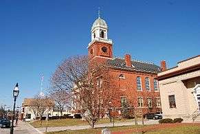
Warwick City Hall | |
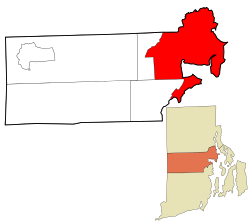 Location in Kent County and the state of Rhode Island. | |
| Coordinates: 41°43′N 71°25′W / 41.717°N 71.417°WCoordinates: 41°43′N 71°25′W / 41.717°N 71.417°W | |
| Country | United States |
| State | Rhode Island |
| County | Kent |
| Incorporated (town) | 1642 |
| Incorporated (city) | 1931 |
| Government | |
| • Type | Mayor-council |
| • Mayor | Scott Avedisian (R) |
| • City Council |
Steven A. Colantuono (R) Thomas H. Chadronet (D) Camille F. Vella Wilkinson (D) Joseph J. Solomon (D) Edgar N. Ladouceur (D) Donna M. Travis (D) Kathleen M. Usler (D) Joseph E. Gallucci (D) Steve Merolla (D) |
| Area | |
| • Total | 49.62 sq mi (128.52 km2) |
| • Land | 35.50 sq mi (91.94 km2) |
| • Water | 14.1 sq mi (36.6 km2) |
| Elevation | 36 ft (11 m) |
| Population (2010) | |
| • Total | 82,672 |
| • Density | 2,328.8/sq mi (899.2/km2) |
| Time zone | Eastern (UTC-5) |
| • Summer (DST) | Eastern (UTC-4) |
| ZIP code | 02886, 02888, 02889 |
| Area code(s) | 401 |
| FIPS code | 44-74300[1] |
| GNIS feature ID | 1220018[2] |
| Website | www.warwickri.gov |
Warwick (locally /ˈwɔːrwɪk/) is a city in Kent County, Rhode Island, United States. It is the second largest city in the state, with a population of 82,672 at the 2010 census. The City of Warwick and T.F. Green Airport are located approximately 12 miles (19 km) south of downtown Providence, 63 miles (101 km) southwest of Boston, Massachusetts, and 171 miles (275 km) northeast of New York City. Its mayor has been Scott Avedisian since 2000.
Warwick was founded by Samuel Gorton in 1642 and has witnessed major events in American history. It was decimated during King Philip's War (1675–76) and was the site of the Gaspee Affair, a significant prelude to the American Revolution. Warwick is also the home of revolutionary war general Nathanael Greene, George Washington's second-in-command, and Civil War General George S. Greene, hero of the battle of Gettysburg.
Warwick is home to Rhode Island's main airport T. F. Green Airport, which serves the greater Providence area and also functions as a reliever for Logan International Airport in Boston, Massachusetts. It is also the home of the 43rd Military Police Brigade of the Rhode Island Army National Guard.
Early history
Warwick was founded in 1642 by Samuel Gorton when Narragansett Indian Chief Sachem Miantonomi agreed to accept 144 fathoms of Wampum for what was known as "The Shawhomett Purchase". This included the present day towns of Coventry and West Warwick. However, the purchase was not without dispute. The two sachems of the area, Sacononoco and Pumham, stated that Miantonomi had sold the land without asking for their approval. They took their case to Boston, where they placed their lands under Massachusetts rule. In 1643, Massachusetts Bay Colony sent a militia force to Shawomett to arrest Gorton and his followers. After a tense standoff, all but three of the Gortonists surrendered to the Massachusetts force. This event caused the other three settlements on Narragansett Bay (Providence, Portsmouth, and Newport) to unite and get a royal charter allowing them to form the Colony of Rhode Island and Providence Plantations.
In 1648, Gorton was granted a Charter by Robert Rich, 2nd Earl of Warwick, Lord Admiral and head of the Parliamentary Commission on Plantation Affairs. Because of this, the name of the settlement was changed from Shawhomett to Warwick. Massachusetts continued to lay claim to the area, but it made no further effort to enforce it.
In 1772, Warwick was the scene of the first violent act against the Crown in what came to be called the Gaspee Affair. Local patriots mooned[3] and then boarded the Gaspee, a revenue cutter charged with enforcing the Stamp Act 1765 and Townshend Acts in Narragansett Bay where smuggling was common. It was here that the first blood was spilled in the American Revolution when Gaspee's commanding officer Lt. Dudingston was shot in his crotch while resisting the taking of his ship. The Gaspee was stripped of all cannon and arms before being torched.
During the Revolution, Warwick militiamen participated in the battles of Montreal, Quebec, Saratoga, Monmouth, and Trenton, and were present for the surrender at Yorktown.
Transportation
T. F. Green Airport is a station on the Providence/Stoughton Commuter Rail Line, providing weekday service to Providence Station and Boston's South Station.
Climate
| Climate data for Warwick, Rhode Island (T.F. Green Airport), 1981–2010 normals | |||||||||||||
|---|---|---|---|---|---|---|---|---|---|---|---|---|---|
| Month | Jan | Feb | Mar | Apr | May | Jun | Jul | Aug | Sep | Oct | Nov | Dec | Year |
| Record high °F (°C) | 69 (21) |
72 (22) |
90 (32) |
98 (37) |
96 (36) |
98 (37) |
102 (39) |
104 (40) |
100 (38) |
88 (31) |
81 (27) |
77 (25) |
104 (40) |
| Average high °F (°C) | 37.4 (3) |
40.3 (4.6) |
47.8 (8.8) |
58.6 (14.8) |
68.4 (20.2) |
77.5 (25.3) |
82.8 (28.2) |
81.4 (27.4) |
74.2 (23.4) |
63.3 (17.4) |
53.2 (11.8) |
42.3 (5.7) |
60.6 (15.9) |
| Average low °F (°C) | 21.0 (−6.1) |
23.6 (−4.7) |
30.0 (−1.1) |
39.6 (4.2) |
48.6 (9.2) |
58.4 (14.7) |
64.2 (17.9) |
63.2 (17.3) |
55.3 (12.9) |
43.9 (6.6) |
35.7 (2.1) |
26.3 (−3.2) |
42.5 (5.8) |
| Record low °F (°C) | −13 (−25) |
−17 (−27) |
1 (−17) |
11 (−12) |
29 (−2) |
39 (4) |
48 (9) |
40 (4) |
32 (0) |
20 (−7) |
6 (−14) |
−12 (−24) |
−17 (−27) |
| Average precipitation inches (mm) | 3.76 (95.5) |
3.34 (84.8) |
5.00 (127) |
4.36 (110.7) |
3.55 (90.2) |
3.64 (92.5) |
3.28 (83.3) |
3.60 (91.4) |
3.92 (99.6) |
3.92 (99.6) |
4.51 (114.6) |
4.21 (106.9) |
47.09 (1,196.1) |
| Average snowfall inches (cm) | 10.3 (26.2) |
8.6 (21.8) |
5.6 (14.2) |
0.7 (1.8) |
0 (0) |
0 (0) |
0 (0) |
0 (0) |
0 (0) |
0 (0) |
1.4 (3.6) |
7.3 (18.5) |
33.8 (85.9) |
| Average precipitation days (≥ 0.01 in) | 11.0 | 9.7 | 11.9 | 11.3 | 12.0 | 10.9 | 9.4 | 9.0 | 8.7 | 9.4 | 10.1 | 11.6 | 125.0 |
| Average snowy days (≥ 0.1 in) | 5.6 | 4.7 | 3.4 | 0.6 | 0 | 0 | 0 | 0 | 0 | 0 | 0.6 | 3.4 | 18.3 |
| Mean monthly sunshine hours | 170.5 | 175.2 | 217.0 | 225.0 | 254.2 | 273.0 | 291.4 | 263.5 | 234.0 | 207.7 | 147.0 | 148.8 | 2,607.3 |
| Source #1: NOAA (extremes 1904–present),[4] The Weather Channel[5] | |||||||||||||
| Source #2: HKO (sun only, 1961–1990)[6] | |||||||||||||
Geography
Warwick is located at 41°43′N 71°25′W / 41.717°N 71.417°W (41.7181, -71.4152).[7]
According to the United States Census Bureau, the city has a total area of 49.6 square miles (128 km2), of which, 35.5 square miles (92 km2) of it is land and 14.1 square miles (37 km2) of it (28.46%) is water.
The following villages are located in Warwick:
- Apponaug[8]
- Arnold's Neck[8]
- Brush Neck Cove[8]
- Buttonwoods[8]
- Cedar Tree Point[8]
- Chepiwanoxet[8]
- Coles[8]
- Conimicut[8]
- Cowesett[8]
- Dryden Heights[8]
- Duby Grove[8]
- East Natick[8]
- Gaspee point [8]
- Goddard Park[8]
- Grant Point[8]
- Greenwood[8]
- Governor Francis Farms[8]
- Hillsgrove[8]
- Hoxsie[8]
- Knight[8]
- Lakewood[8]
- Lincoln Park[8]
- Lockwood Corner[8]
- Nausauket[8]
- Natick[8]
- Norwood[8]
- Oakland Beach[8]
- Old Buttonwoods[8]
- Pawtuxet Village (also in Cranston)[8]
- Pocasset[8]
- Pontiac (also in Cranston)[8]
- Potowomut[8]
- Riverview[8]
- Shawomet[8]
- Warwick Neck[8]
- Wildes Corner[8]
Demographics
| Historical population | |||
|---|---|---|---|
| Census | Pop. | %± | |
| 1830 | 5,529 | — | |
| 1840 | 6,726 | 21.6% | |
| 1850 | 7,740 | 15.1% | |
| 1860 | 8,916 | 15.2% | |
| 1870 | 10,453 | 17.2% | |
| 1880 | 12,164 | 16.4% | |
| 1890 | 17,761 | 46.0% | |
| 1900 | 21,316 | 20.0% | |
| 1910 | 26,629 | 24.9% | |
| 1920 | 13,481 | −49.4% | |
| 1930 | 23,196 | 72.1% | |
| 1940 | 28,757 | 24.0% | |
| 1950 | 43,028 | 49.6% | |
| 1960 | 68,504 | 59.2% | |
| 1970 | 83,694 | 22.2% | |
| 1980 | 87,123 | 4.1% | |
| 1990 | 85,427 | −1.9% | |
| 2000 | 85,808 | 0.4% | |
| 2010 | 82,672 | −3.7% | |
| Est. 2015 | 81,699 | [9] | −1.2% |
| U.S. Decennial Census | |||
Warwick is officially a part of the Providence metropolitan area, which has a population of 1,600,852 in 2010 census. As of the census[1] of 2000, there were 85,808 people, 35,517 households, and 22,979 families residing in the city. The population density was 2,417.2 people per square mile (933.3/km²). There were 37,085 housing units at an average density of 1,044.7 per square mile (403.3/km²). The racial makeup of the city was 95.21% White, 1.16% African American, 0.25% Native American, 1.49% Asian, 0.02% Pacific Islander, 0.59% from other races, and 1.28% from two or more races. Hispanic or Latino of any race were 1.60% of the population.
There were 35,517 households out of which 27.4% had children under the age of 18 living with them, 50.7% were married couples living together, 10.2% had a female householder with no husband present, and 35.3% were non-families. 29.8% of all households were made up of individuals and 13.2% had someone living alone who was 65 years of age or older. The average household size was 2.39 and the average family size was 2.99.
In the city the population was spread out with 21.9% under the age of 18, 6.7% from 18 to 24, 30.1% from 25 to 44, 24.3% from 45 to 64, and 17.0% who were 65 years of age or older. The median age was 40 years. For every 100 females there were 90.8 males. For every 100 females age 18 and over, there were 87.2 males.
The median income for a household in the city was $46,483, and the median income for a family was $56,225. Males had a median income of $39,455 versus $28,946 for females. The per capita income for the city was $23,410. About 4.2% of families and 5.9% of the population were below the poverty line, including 6.4% of those under age 18 and 7.5% of those age 65 or over.
Economy
Before its dissolution, Eckerd Corporation had its headquarters in Warwick.[10]
The ten largest employers in Warwick are Kent Memorial Hospital, Citizens Bank- Warwick Call Center, UPS, MetLife, City of Warwick, Leviton Manufacturing, Wal-Mart, Community College of Rhode Island, J.C. Penney, Kenney Manufacturing, and Inskip Automall.
Notable people
- Richard S. Aldrich, U.S. Representative[11]
- Bill Almon, MLB Baseball player attended Warwick Veterans Memorial High School
- Rocco Baldelli, MLB Baseball Player who attended Bishop Hendricken High School
- John Brown (Rhode Island), American merchant, slave trader and participant in the Gaspee Affair. Brown University is name for him.
- Lincoln Chafee, Former Governor of RI, and subsequently led an unsuccessful run for the Presidency.
- John Chafee, Former Governor of RI, United States Secretary of the Navy under President Richard M. Nixon, and U.S. senator.
- Christine Bannon-Rodrigues, martial artist and actress
- George M. Cohan Considered the father of Broadway, was from Fox Point, Providence.
- Damian Costantino, NCAA record holder with hits in 60 consecutive games.[12]
- Sara Decosta, US Women's hockey goalie
- Peter Gemma, writer and conservative political activist; reared in Warwick
- George Sears Greene, U.S. Civil War general
- Nathanael Greene, Revolutionary War general and second in command to George Washington
- Jason Hawes and Grant Wilson, paranormal investigators, founders of The Atlantic Paranormal Society, and hosts of Ghost Hunters
- Kevin McLaughlin, pharmaceutical validation test engineer, Toll Gate High School alumni, 1978
- Michaela McManus, actress
- Deborah Messing, actress "Will and Grace"
- Walter Mossberg, technology editor for the Wall Street Journal
- Raymond Nels Nelson, Bureau Chief of the Providence Journal and Evening Bulletin in Warwick, Rhode Island and murdered Senate staffer
- Matthew Calbraith Perry,Commodore,U.S. Navy, served in the Mexican-American War and the War of 1812. Considered the father of the "Steam Navy".
- Oliver Hazard Perry, U.S. Navy Captain, hero of the Battle of Lake Erie, War of 1812.
- Lorraine K. Potter, Chief of Chaplains of the U.S. Air Force
- Craig Price, murderer from Buttonwoods, attended Warwick Veterans Memorial High School
- Chris Terreri, NHL goalie attended Pilgrim High School
- Dan Wheeler, Major League pitcher attended Pilgrim High School
- Doug White, former NBC 10 News Anchor
- Fred Whittingham, NFL player and coach, attended Warwick Veterans Memorial High School
- Roger Williams, founder of Providence Plantation 1636.
- James Woods, actor, attended Pilgrim High School
Education
.JPG)
Local public schools are operated by Warwick Public Schools.[13] Toll Gate High School, and Pilgrim High School are the two comprehensive public high schools located in Warwick. The two public middle schools are Winman Junior High School, and Warwick Veterans Junior High School. Aldrich Junior High School and Gorton Junior High School have recently closed as part of the school consolidation project in Warwick. Warwick Public Schools are headed by superintendent, Phillip Thorton.
Bishop Hendricken High School is an all-male college preparatory Catholic high school located in Warwick. Rocky Hill School is a P-12 coed secular country day school located on Warwick's isolated Potowomut peninsula. Despite RHS being geographically included as part of the city of Warwick, the school lists an intentionally erroneous East Greenwich address.
The Community College of Rhode Island Knight Campus is also located in Warwick on the former Knight Estate.
References
- 1 2 "American FactFinder". United States Census Bureau. Retrieved 2008-01-31.
- ↑ "US Board on Geographic Names". United States Geological Survey. 2007-10-25. Retrieved 2008-01-31.
- ↑ The Deliberate Attack on the Gaspee
- ↑ "NowData – NOAA Online Weather Data". National Oceanic and Atmospheric Administration. Retrieved January 28, 2012.
- ↑ "Monthly average temperatures and precipitation". The Weather Channel. Retrieved 2009-08-30.
- ↑ "Climatological Normals of Providence". Hong Kong Observatory. Retrieved 2013-05-04.
- ↑ "US Gazetteer files: 2010, 2000, and 1990". United States Census Bureau. 2011-02-12. Retrieved 2011-04-23.
- 1 2 3 4 5 6 7 8 9 10 11 12 13 14 15 16 17 18 19 20 21 22 23 24 25 26 27 28 29 30 31 32 33 34 35 36 RI.gov: Cities & Towns
- ↑ "Annual Estimates of the Resident Population for Incorporated Places: April 1, 2010 to July 1, 2015". Retrieved July 2, 2016.
- ↑ "Contacting Us." Eckerd Corporation. Retrieved on June 19, 2010. "Mail: 50 Service Ave., Warwick, RI 02886."
- ↑ Rhode Island. Dept. of State (1916). Manual, with Rules and Orders, for the Use of the General Assembly of the State of Rhode Island. Rhode Island. Dept. of State. p. 393.
- ↑ Derewicz, Mark. "Costantino's hitting streak breaks record", Warwick Veterans Memorial High School Baseball America, March 11, 2003. Accessed June 6, 2010.
- ↑ Warwick Public Schools website
External links
| Wikimedia Commons has media related to Warwick, Rhode Island. |
| Wikivoyage has a travel guide for Warwick (Rhode Island). |
- City of Warwick, Rhode Island Website
- Macaroni Kid - Cranston/Kent County - A family friendly events calendar
- Warwick Museum of Art
- Warwick Public Library
- Pawtuxet Cove
- City Of Warwick Police Department
- City of Warwick Fire Department
- Affair of the Gaspee
- Gaspee Days
- Warwick's Dept. of Tourism
- Quahog.org
Municipalities and communities of Kent County, Rhode Island, United States | ||
|---|---|---|
| City |  | |
| Towns | ||
| Villages | ||
Providence (capital) | |
| Topics |
|
| Society |
|
| Regions | |
| Cities | |
| Towns |
|
| Islands |  | |
|---|---|---|
| Major rivers | ||
| Cities & towns | ||
| Bridges | ||