North Walpole, New Hampshire
| North Walpole, New Hampshire | |
|---|---|
| Census-designated place | |
 North Walpole  North Walpole | |
| Coordinates: 43°8′20″N 72°26′53″W / 43.13889°N 72.44806°WCoordinates: 43°8′20″N 72°26′53″W / 43.13889°N 72.44806°W | |
| Country | United States |
| State | New Hampshire |
| County | Cheshire |
| Town | Walpole |
| Area | |
| • Total | 0.7 sq mi (1.8 km2) |
| • Land | 0.7 sq mi (1.8 km2) |
| • Water | 0.0 sq mi (0.0 km2) |
| Elevation | 308 ft (94 m) |
| Population (2010) | |
| • Total | 828 |
| • Density | 1,200/sq mi (460/km2) |
| Time zone | Eastern (EST) (UTC-5) |
| • Summer (DST) | EDT (UTC-4) |
| ZIP code | 03609 |
| Area code(s) | 603 |
| FIPS code | 33-56420 |
| GNIS feature ID | 0868821 |
North Walpole is a census-designated place in the town of Walpole in Cheshire County, New Hampshire. It had a population of 828 at the 2010 census.[1]
It is located in the northwestern corner of the town of Walpole, along New Hampshire Route 12 and directly across the Connecticut River from the village of Bellows Falls, Vermont. North Walpole has a separate ZIP code (03609) from the rest of Walpole.
History
Spring snowmelt brought log drives down the Connecticut River. Log drivers were stationed to guide logs through a sluice over the dam at Bellows Falls. North Walpole offered twelve to eighteen saloons to quench log drivers' thirst.[2] These spring drives were stopped after 1915, when pleasure boat owners complained about the hazards to navigation.[3]
References
- ↑ United States Census Bureau, American FactFinder, 2010 Census figures. Retrieved March 23, 2011.
- ↑ Holbrook, Stewart H. (1961). Yankee Loggers. International Paper Company. p. 70.
- ↑ Wheeler, Scott (September 2002). The History of Logging in Vermont's Northeast Kingdom. The Kingdom Historical.
Municipalities and communities of Cheshire County, New Hampshire, United States | ||
|---|---|---|
| City | 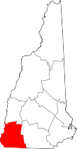 | |
| Towns | ||
| CDPs | ||
| Other villages | ||