Obubra
| Obubra | |
|---|---|
| LGA and town | |
 Obubra Location in Nigeria | |
| Coordinates: 6°05′0″N 8°20′0″E / 6.08333°N 8.33333°ECoordinates: 6°05′0″N 8°20′0″E / 6.08333°N 8.33333°E | |
| Country |
|
| State | Cross River State |
| Areathere are several communities in Obubra, including Yala, Ochun, Iyamitet, Apiapum, Ugep. There are also several towns and villages in Obubra LGA. The Local Government Chairman can help to document details in the web. | |
| • Total | 431 sq mi (1,115 km2) |
| Time zone | WAT (UTC+1) |
Obubra is a Local Government Area of Cross River State, Nigeria. Its headquarters are in the town of Obubra, which is home to the Ibrahim Babangida College of Agriculture.[1] The National Youth Service Corps, Cross River State Orientation Camp is situated in Obubra Village of this Local Government Area.
It has an area of 1,115 km² and a population of 172,444 at the 2006 census.
The postal code of the area is 551.[2]
References
- ↑ "LIST OF INSTITUTIONS FOR 2008 BATCH 'B' SERVICE YEAR". National Youth Services Corp. Retrieved 2010-03-21.
- ↑ "Post Offices- with map of LGA". NIPOST. Archived from the original on 2012-11-26. Retrieved 2009-10-20.
3. "Kelvin Hycenth Secretary to the Chairman
State capital: Calabar | ||
| LGAs | 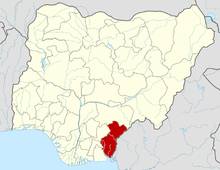 | |
Rev. Chris is the Executive Chairman of the Local Government Area.
3. Rev. Chris is the Executive Chairman of the Local Government Area.
This article is issued from Wikipedia - version of the 9/12/2016. The text is available under the Creative Commons Attribution/Share Alike but additional terms may apply for the media files.