Pecan Grove, Texas
| Pecan Grove, Texas | |
|---|---|
| Census-designated place | |
|
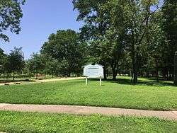
Plantation Memorial Park in Pecan Grove | |
 | |
| Coordinates: 29°37′33″N 95°43′53″W / 29.62583°N 95.73139°WCoordinates: 29°37′33″N 95°43′53″W / 29.62583°N 95.73139°W | |
| Country | United States |
| State | Texas |
| County | Fort Bend |
| Area | |
| • Total | 8.8 sq mi (22.9 km2) |
| • Land | 8.7 sq mi (22.5 km2) |
| • Water | 0.2 sq mi (0.4 km2) |
| Elevation | 82 ft (25 m) |
| Population (2010) | |
| • Total | 15,963 |
| • Density | 1,834/sq mi (708.3/km2) |
| Time zone | Central (CST) (UTC-6) |
| • Summer (DST) | CDT (UTC-5) |
| ZIP code | 76561 |
| FIPS code | 48-56482 |
| GNIS feature ID | 1867561 |
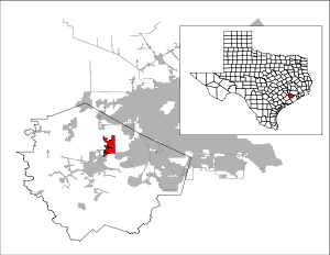
Pecan Grove is a census-designated place and master-planned community within the extraterritorial jurisdiction of Richmond in Fort Bend County, Texas, United States. The population was 15,963 at the 2010 census.[1]
Geography
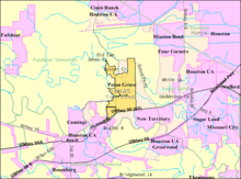
Pecan Grove is located northeast of the center of Fort Bend County at 29°37′34″N 95°43′54″W / 29.62611°N 95.73167°W (29.626060, -95.731591).[2] It is bordered to the southwest by the Brazos River. The city limits of Richmond form a convoluted pattern in the southern part of the CDP, and the northern part is bordered by an exclave of the city of Houston. Downtown Richmond is 4 miles (6 km) southwest of the center of Pecan Grove, and downtown Houston is 29 miles (47 km) to the northeast.
According to the United States Census Bureau, the Pecan Grove CDP has a total area of 8.8 square miles (22.9 km2), of which 8.7 square miles (22.5 km2) is land and 0.2 square miles (0.4 km2), or 1.69%, is water.[1]
Demographics
As of the census[3] of 2000, there were 13,551 people, 4,516 households, and 3,847 families residing in the CDP. The population density was 1,552.2 people per square mile (599.3/km²). There were 4,662 housing units at an average density of 534.0/sq mi (206.2/km²). The racial makeup of the CDP was 91.29% White, 3.29% African American, 0.19% Native American, 1.34% Asian, 2.51% from other races, and 1.38% from two or more races. Hispanic or Latino of any race were 9.08% of the population.
There were 4,516 households out of which 52.5% had children under the age of 18 living with them, 76.3% were married couples living together, 7.0% had a female householder with no husband present, and 14.8% were non-families. 12.8% of all households were made up of individuals and 2.7% had someone living alone who was 65 years of age or older. The average household size was 3.00 and the average family size was 3.29.
In the CDP the population was spread out with 33.4% under the age of 18, 5.3% from 18 to 24, 31.9% from 25 to 44, 24.6% from 45 to 64, and 4.8% who were 65 years of age or older. The median age was 35 years. For every 100 females there were 98.3 males. For every 100 females age 18 and over, there were 95.8 males.
The median income for a household in the CDP was $83,515, and the median income for a family was $91,059. Males had a median income of $62,213 versus $37,658 for females. The per capita income for the CDP was $33,816. About 0.6% of families and 1.3% of the population were below the poverty line, including 0.5% of those under age 18 and 2.2% of those age 65 or over.
Government and infrastructure
A portion of the Texas Department of Criminal Justice Jester State Prison Farm property is located in Pecan Grove.[4][5]
Education
Most of the students who live in Pecan Grove are zoned to Fort Bend ISD schools. The Fort Bend ISD attendance zone for Pecan Grove is:
- Pecan Grove Elementary (Grades PK-5), located in Pecan Grove[4][6][7]
- James Bowie Middle School (Grades 6-8), located in Pecan Grove[4][8][9]
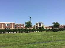
- Travis High School (Grades 9-12), located in Pecan Grove[4][10][11]
Other students who live in Pecan Grove area are zoned to Lamar Consolidated ISD Schools. The Lamar Consolidated ISD zone for Pecan Grove is:
Students zoned to Austin Elementary use the following feeder pattern:
- Austin Elementary (Grades PK-5)
- Wessendorff Middle School(Grade 6)
- Lamar Junior High (Grades 7-8)
- Lamar Consolidated High School ( Grades 9-12)
Students zoned to Frost Elementary use the following feeder pattern:
- Frost Elementary(Grades PK-5)
- Wertheimer Middle School (Grade 6)
- Briscoe Junior High (Grades 7-8)
- Foster High School ( Grades 9-12)
Notable people
- W. A. Criswell, two-term president of the Southern Baptist Convention
References
- 1 2 "Geographic Identifiers: 2010 Demographic Profile Data (G001): Pecan Grove CDP, Texas". U.S. Census Bureau, American Factfinder. Retrieved September 2, 2016.
- ↑ "US Gazetteer files: 2010, 2000, and 1990". United States Census Bureau. 2011-02-12. Retrieved 2011-04-23.
- ↑ "American FactFinder". United States Census Bureau. Retrieved 2008-01-31.
- 1 2 3 4 "Pecan Grove CDP, Texas." U.S. Census Bureau. Retrieved on September 23, 2010.
- ↑ "Page-541." Texas Department of Transportation. Retrieved on October 5, 2011.
- ↑ "Elementary School Attendance Zones 2011-2012 School Year." Fort Bend Independent School District. Retrieved on September 12, 2011.
- ↑ "Pecan Grove Elementary Attendance Zone." Fort Bend Independent School District. Retrieved on September 12, 2011.
- ↑ "Middle School Attendance Zones 2011-2012 School Year." Fort Bend Independent School District. Retrieved on September 12, 2011.
- ↑ "Bowie Middle School Attendance Zone." Fort Bend Independent School District. Retrieved on September 12, 2011.
- ↑ "High School Attendance Zones 2011-2012 School Year." Fort Bend Independent School District. Retrieved on September 12, 2011.
- ↑ "Travis High School Attendance Zone." Fort Bend Independent School District. Retrieved on September 12, 2011.
External links
- Pecan Grove, Texas (Fort Bend County) from the Handbook of Texas Online
Municipalities and communities of Fort Bend County, Texas, United States | ||
|---|---|---|
| Cities |  | |
| Town | ||
| Villages | ||
| CDPs | ||
| Unincorporated communities | ||
| Ghost towns | ||
| Footnotes | ‡This populated place also has portions in an adjacent county or counties;
±Former community annexed by Missouri City | |