Trammels, Missouri City, Texas
| Trammels, Missouri City, Texas | |
|---|---|
| Neighborhood | |
 Trammels  Trammels Location within the state of Texas | |
| Coordinates: 29°32′05″N 95°32′15″W / 29.53472°N 95.53750°WCoordinates: 29°32′05″N 95°32′15″W / 29.53472°N 95.53750°W | |
| Country | United States |
| State | Texas |
| County | Fort Bend |
| Elevation | 66 ft (20 m) |
| Time zone | Central (CST) (UTC-6) |
| • Summer (DST) | CDT (UTC-5) |
| ZIP code | 77459 |
| Area code(s) | 281, 713, 832 |
| GNIS feature ID | 1379172[1] |
Trammels was an unincorporated area near State Highway 6 in eastern Fort Bend County. The one-time community was annexed by the municipality of Missouri City, a Houston suburb. Trammels was located fourteen miles northeast of Richmond at the junction of a graded and drained road and Texas State Highway 6.
Location
Trammels is located at the junction of State Highway 6 and Trammel-Fresno Road 14 miles east of Richmond. The town is located approximately halfway between U.S. Highway 59 and State Highway 288, two freeways that serve the Houston area, on State Highway 6. The town appears on a map published by Color-Art, Inc. of Houston, Texas and vicinity.
History
Little is known regarding early history of the town though there is some records of the development of the neighboring town of DeWalt. In 1936, the community had a row of dwellings, one business, and five farm units. Although Trammels appeared on county maps, population statistics were never recorded. A portion of the town is covered by a small man-made lake. The remaining areas of Trammels became a part of the DeWalt community. As of 2008 what was Trammels is now in the city limits of Missouri City.[2]
References
- Houston, TX and Vicinity, Color-Art, Inc., A Cenveo Company, St. Louis, Missouri, printed 12-06 #2500042, 2006 edition (map).
External links
- Trammels, Texas from the Handbook of Texas Online
Municipalities and communities of Fort Bend County, Texas, United States | ||
|---|---|---|
| Cities | 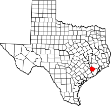 | |
| Town | ||
| Villages | ||
| CDPs | ||
| Unincorporated communities | ||
| Ghost towns | ||
| Footnotes | ‡This populated place also has portions in an adjacent county or counties;
±Former community annexed by Missouri City | |