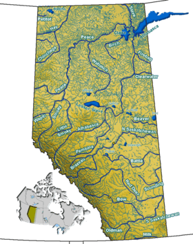
Peyto Lake
| Peyto Lake | |
|---|---|
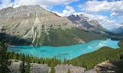 Peyto Lake seen from Bow Summit | |
| Location | Banff National Park, Alberta, Canada |
| Coordinates | 51°43′37″N 116°31′19″W / 51.72694°N 116.52194°WCoordinates: 51°43′37″N 116°31′19″W / 51.72694°N 116.52194°W |
| Type | Glacial |
| Primary inflows | Peyto Creek |
| Primary outflows | Mistaya River |
| Basin countries | Canada |
| Max. length | 2.8 km (1.7 mi) |
| Max. width | 0.8 km (0.50 mi) |
| Surface area | 5.3 km2 (2.0 sq mi) |
| Surface elevation | 1,880 m (6,170 ft) |
Peyto Lake (/ˈpiːtoʊ/ PEE-toh) is a glacier-fed lake in Banff National Park in the Canadian Rockies. The lake itself is easily accessed from the Icefields Parkway. It was named for Bill Peyto, an early trail guide and trapper in the Banff area.[1]
The lake is formed in a valley of the Waputik Range, between Caldron Peak, Peyto Peak and Mount Jimmy Simpson, at an elevation of 1,860 m (6,100 ft).
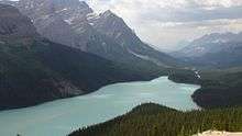
During the summer, significant amounts of glacial rock flour flow into the lake, and these suspended rock particles give the lake a bright, turquoise colour. Because of its bright colour, photos of the lake often appear in illustrated books, and the area around the lake is a popular sightseeing spot for tourists. The lake is best seen from Bow Summit, the highest point on the Icefields Parkway.[2]
The lake is fed by Peyto Creek, which drains water from Caldron Lake and Peyto Glacier (part of the Wapta Icefield). Peyto Lake is the origin of the Mistaya River,[3] which heads northwest from the lake's outflow.

References
External links
![]() Media related to Peyto Lake at Wikimedia Commons
Media related to Peyto Lake at Wikimedia Commons
-
 Peyto Lake travel guide from Wikivoyage
 - Parks Canada - Banff National Park