Pike Township, Warren County, Indiana
| Pike Township | |
|---|---|
| Township | |
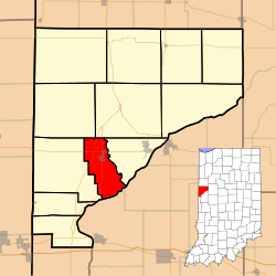 Location of Pike Township in Warren County | |
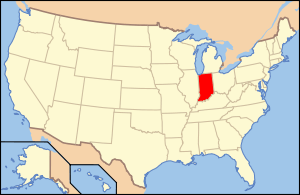 Location of Indiana in the United States | |
| Coordinates: 40°15′21″N 87°23′20″W / 40.25583°N 87.38889°WCoordinates: 40°15′21″N 87°23′20″W / 40.25583°N 87.38889°W | |
| Country | United States |
| State | Indiana |
| County | Warren |
| Government | |
| • Type | Indiana township |
| Area | |
| • Total | 17.56 sq mi (45.5 km2) |
| • Land | 17.36 sq mi (45.0 km2) |
| • Water | 0.2 sq mi (0.5 km2) 1.14% |
| Elevation | 666 ft (203 m) |
| Population (2010) | |
| • Total | 1,221 |
| • Density | 70.3/sq mi (27.1/km2) |
| Time zone | Eastern (EST) (UTC-5) |
| • Summer (DST) | EDT (UTC-4) |
| GNIS feature ID | 453737 |
Pike Township is one of twelve townships in Warren County, Indiana, United States. According to the 2010 census, its population was 1,221 and it contained 529 housing units.[1]
History
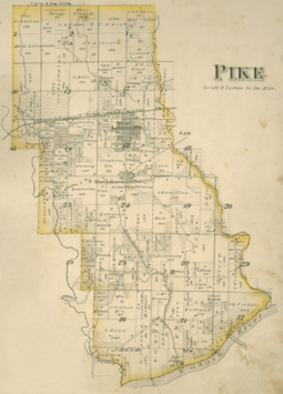
Pike Township was one of the four original townships in the county, formed on November 6, 1827.[2]
Geography
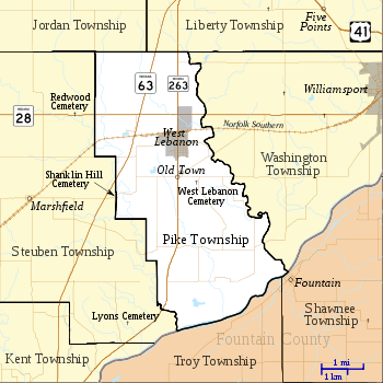
According to the 2010 census, the township has a total area of 17.56 square miles (45.5 km2), of which 17.36 square miles (45.0 km2) (or 98.86%) is land and 0.2 square miles (0.52 km2) (or 1.14%) is water.[1] The streams of Dry Branch, Foster Branch, Johnson Branch, Jordan Creek and Redwood Creek run through this township. Pike Township has two towns: West Lebanon, with a population of 793 and contains two-thirds of the residents of the township, and Old Town.
Cemeteries
The township contains two cemeteries. Shanklin Hill Cemetery is a small burial ground located on the western border of the township.[3] West Lebanon Cemetery is much larger and is located southeast of the town.[4]
Transportation
Indiana State Road 28 passes through the north end of the township on its route from the Illinois state line in the west to Williamsport (and beyond) in the east.[5] Indiana State Road 63 begins in Liberty Township just to the north, and runs through the western part of Pike Township on its way south to Terre Haute.[6] Indiana State Road 263 begins at State Road 63 and passes through West Lebanon, re-joining State Road 63 in the south part of the county.[7]
Education
Pike Township is part of the Metropolitan School District of Warren County. It contains the county's only high school, Seeger Memorial Junior-Senior High School, located on State Road 263 north of West Lebanon; one of the three elementary schools, Warren Central Elementary School, is co-located with Seeger.[8]
Government
Pike Township has a trustee who administers rural fire protection and ambulance service, provides relief to the poor, manages cemetery care, and performs farm assessment, among other duties. The trustee is assisted in these duties by a three-member township board. The trustees and board members are elected to four-year terms.[9]
Pike Township is part of Indiana's 8th congressional district, Indiana House of Representatives District 42,[10] and Indiana State Senate District 38.[11]
Climate and weather
| West Lebanon, Indiana | ||||||||||||||||||||||||||||||||||||||||||||||||||||||||||||
|---|---|---|---|---|---|---|---|---|---|---|---|---|---|---|---|---|---|---|---|---|---|---|---|---|---|---|---|---|---|---|---|---|---|---|---|---|---|---|---|---|---|---|---|---|---|---|---|---|---|---|---|---|---|---|---|---|---|---|---|---|
| Climate chart (explanation) | ||||||||||||||||||||||||||||||||||||||||||||||||||||||||||||
| ||||||||||||||||||||||||||||||||||||||||||||||||||||||||||||
| ||||||||||||||||||||||||||||||||||||||||||||||||||||||||||||
In recent years, average temperatures in West Lebanon have ranged from a low of 15 °F (−9 °C) in January to a high of 85 °F (29 °C) in July, with a record low of −26 °F (−32 °C) recorded in January 1994 and a record high of 105 °F (41 °C) recorded in August 1988. Average monthly precipitation ranged from 1.80 inches (46 mm) in February to 4.53 inches (115 mm) in June.[12]
References
- 1 2 "Population, Housing Units, Area, and Density: 2010 - County -- County Subdivision and Place -- 2010 Census Summary File 1". United States Census. Retrieved 2013-05-10.
- ↑ Warren County Historical Society 1966, p. 62.
- ↑ "Shanklin Hill Cemetery". Geographic Names Information System. United States Geological Survey. Retrieved 2011-02-05.
- ↑ "West Lebanon Cemetery". Geographic Names Information System. United States Geological Survey. Retrieved 2011-02-05.
- ↑ "State Road 28". Highway Explorer. Retrieved 2010-09-21.
- ↑ "State Road 63". Highway Explorer. Retrieved 2010-09-21.
- ↑ "State Road 263". Highway Explorer. Retrieved 2010-09-21.
- ↑ "Corporation Snapshot, M S D Warren County #8115". Indiana Department of Education. Retrieved 2011-01-27.
- ↑ "Government". United Township Association of Indiana. Retrieved 2011-01-06.
- ↑ "Indiana Senate" (PDF). State of Indiana. Retrieved 2013-12-02.
- ↑ "Indiana House Districts" (PDF). State of Indiana. Retrieved 2013-12-02.
- 1 2 "Monthly Averages for West Lebanon, Indiana". The Weather Channel. Retrieved 2011-01-27.
- "Pike Township, Warren County, Indiana". Geographic Names Information System. United States Geological Survey. Retrieved 2009-09-24.
- United States Census Bureau TIGER/Line Shapefiles
Bibliography
- Goodspeed, Weston A. (1883). "Part II. History of Warren County". Counties of Warren, Benton, Jasper and Newton, Indiana. Chicago: F. A. Battey and Company. pp. 31–156. Retrieved 2010-09-19.
- Clifton, Thomas, ed. (1913). Past and Present of Fountain and Warren Counties Indiana. Indianapolis: B. F. Bowen and Company. pp. 201–335. Retrieved 2010-09-19.
- Warren County Historical Society (1966). A History of Warren County, Indiana. Williamsport, Indiana.
- Warren County Historical Society (2002). A History of Warren County, Indiana (175th Anniversary Edition). Williamsport, Indiana.
External links
 |
Jordan Township | |
Liberty Township | |
| Steuben Township | |
Washington Township Shawnee Township, Fountain County | ||
| ||||
| | ||||
| Troy Township, Fountain County |
Municipalities and communities of Warren County, Indiana, United States | ||
|---|---|---|
| Towns | ||
| Townships | ||
| Unincorporated communities | ||
| Ghost towns | ||