West Lebanon, Indiana
| West Lebanon | |
|---|---|
| Town | |
 West Lebanon  West Lebanon  West Lebanon | |
| Coordinates: 40°16′14″N 87°23′9″W / 40.27056°N 87.38583°WCoordinates: 40°16′14″N 87°23′9″W / 40.27056°N 87.38583°W | |
| Country | United States |
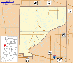
| State | Indiana |
| County | Warren |
| Township | Pike |
| Founded | 1830 |
| Incorporated | 1869 |
| Area[1] | |
| • Total | 0.62 sq mi (1.61 km2) |
| • Land | 0.62 sq mi (1.61 km2) |
| • Water | 0 sq mi (0 km2) |
| Elevation[2] | 712 ft (217 m) |
| Population (2010)[3] | |
| • Total | 723 |
| • Estimate (2012[4]) | 709 |
| • Density | 1,166.1/sq mi (450.2/km2) |
| Time zone | EST (UTC-5) |
| • Summer (DST) | EDT (UTC-4) |
| ZIP code | 47991 |
| Area code(s) | 765 |
| FIPS code | 18-82934[5] |
| GNIS feature ID | 445780 |
West Lebanon is a town in Pike Township, Warren County, in the U.S. state of Indiana.[6] The population was 723 at the 2010 census.[3]
History
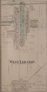
West Lebanon was laid out and platted in the fall of 1830 by Ebenezer Purviance, John G. Jemison and Andrew Fleming, and consisted of 64 lots. Originally named Lebanon, the name was changed to West Lebanon in 1869 when the town was incorporated, possibly in deference to the Boone County community of the same name which established its post office on December 15, 1832, just eleven days before their own.[7]
Not being close to any waterways, West Lebanon's early growth was relatively slow and for many years had no more than 20 families. However, with the completion of the Wabash Railroad line one mile north of town in 1856, the community's fortunes improved and led to most of the town relocating closer to the station. The original settlement area became known as Old Town.[8]
A Carnegie library was built at the corner of High Street and North Street in 1916 and continues to operate as the West Lebanon-Pike Township Public Library.[9]
Fire destroyed part of West Lebanon's business district the evening of January 26, 2011, destroying a row of buildings along the west side of High Street between First and North streets.[10][11]
Geography
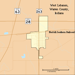
West Lebanon is located just south of State Road 28 about 7.5 miles (12.1 km) east of the Illinois border and about 5 miles (8.0 km) west of Williamsport. State Road 263 is concurrent with High Street and intersects State Road 28 at the north edge of town. A line of the Norfolk Southern Railway also passes through the north edge of the town. Rock Creek, east of town, flows south toward the Wabash River and forms the township's eastern border; it is fed by the small Johnson Branch which crosses the north edge of town.
According to the 2010 census, West Lebanon has a total area of 0.62 square miles (1.61 km2), all land.[1]
Economy
There are more than 25 businesses in West Lebanon. Industry includes Tru-Flex Metal Hose, which has made stripwound and corrugated flexible metal hose since 1962, and Dyna-Fab, which specializes in metal stampings and weldments.[12]
Demographics
| Historical population | |||
|---|---|---|---|
| Census | Pop. | %± | |
| 1880 | 665 | — | |
| 1890 | 644 | −3.2% | |
| 1900 | 688 | 6.8% | |
| 1910 | 642 | −6.7% | |
| 1920 | 637 | −0.8% | |
| 1930 | 595 | −6.6% | |
| 1940 | 581 | −2.4% | |
| 1950 | 642 | 10.5% | |
| 1960 | 720 | 12.1% | |
| 1970 | 899 | 24.9% | |
| 1980 | 946 | 5.2% | |
| 1990 | 760 | −19.7% | |
| 2000 | 793 | 4.3% | |
| 2010 | 723 | −8.8% | |
| Est. 2015 | 703 | [13] | −2.8% |
As of the 2010 United States Census, there were 723 people, 287 households, and 192 families residing here.[15] The population density was 1,174.7 inhabitants per square mile (453.6/km2). There were 327 housing units at an average density of 531.3 per square mile (205.1/km2).[16] The racial makeup was 99.2% white, 0.3% Asian, 0.1% American Indian, 0.1% from other races, and 0.3% from two or more races. Those of Hispanic or Latino origin made up 0.1% of the population.[15] In terms of ancestry, 19.8% were German, 8.4% were Irish, and 6.6% were American.[17]
Of the 287 households, 34.8% had children under the age of 18 living with them, 46.3% were married couples living together, 13.2% had a female householder with no husband present, 33.1% were non-families, and 25.8% of all households were made up of individuals. The average household size was 2.52 and the average family size was 2.98. The median age was 37.4 years.[15]
The median income for a household was $49,226 and the median income for a family was $53,708. Males had a median income of $42,500 versus $34,063 for females. The per capita income for was $19,388. About 1.4% of families and 4.1% of the population were below the poverty line, including 3.3% of those under age 18 and 16.3% of those age 65 or over.[18]
Arts and culture
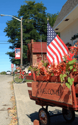
Each year on the last weekend of September the town holds the West Lebanon Patriot Festival, an event named for the Patriot mascot of nearby Seeger High School. The festival features flea market vendors, a parade, cake walks, live music, fireman's water ball competition, outhouse races and other attractions.[19] The festival was previously known as West Lebanon Fun Days.
References
- 1 2 "G001 - Geographic Identifiers - 2010 Census Summary File 1". United States Census Bureau. Retrieved 2015-07-25.
- ↑ "US Board on Geographic Names". United States Geological Survey. 2007-10-25. Retrieved 2008-01-31.
- 1 2 "Profile of General Population and Housing Characteristics: 2010". United States Census Bureau. Retrieved 2013-11-23.
- ↑ "Population Estimates". United States Census Bureau. Retrieved 2013-06-25.
- ↑ "American FactFinder". United States Census Bureau. Retrieved 2008-01-31.
- ↑ "West Lebanon, Indiana". Geographic Names Information System. United States Geological Survey. Retrieved 2016-07-10.
- ↑ Baker, Ronald L.; Carmony, Marvin (1975). Indiana Place Names. Bloomington, Indiana: Indiana University Press. p. 176.
- ↑ "Old Town". Geographic Names Information System. United States Geological Survey.
- ↑ "West Lebanon-Pike Township Public Library". Retrieved 2012-10-02.
- ↑ "Fire ravages West Lebanon business district". Journal and Courier. 26 January 2011. Retrieved 31 January 2011.
- ↑ Weddle, Eric (27 January 2011). "Wood stove cited as cause in West Lebanon fire". Journal and Courier. Retrieved 31 January 2011.
- ↑ Warren County Local Economic Development Organization. "Business Directory". Retrieved 2010-09-18.
- ↑ "Annual Estimates of the Resident Population for Incorporated Places: April 1, 2010 to July 1, 2015". Retrieved July 2, 2016.
- ↑ "Census of Population and Housing". Census.gov. Retrieved June 4, 2015.
- 1 2 3 "DP-1 Profile of General Population and Housing Characteristics: 2010 Demographic Profile Data". United States Census Bureau. Retrieved 2015-07-10.
- ↑ "Population, Housing Units, Area, and Density: 2010". United States Census Bureau. Retrieved 2015-07-10.
- ↑ "DP02 SELECTED SOCIAL CHARACTERISTICS IN THE UNITED STATES – 2006-2010 American Community Survey 5-Year Estimates". United States Census Bureau. Retrieved 2015-07-10.
- ↑ "DP03 SELECTED ECONOMIC CHARACTERISTICS – 2006-2010 American Community Survey 5-Year Estimates". United States Census Bureau. Retrieved 2015-07-10.
- ↑ Edwards, Rebecca (2007-10-04). "Patriot Fest Celebrates Hometown Heritage". The Review Republican. p. 1.
- Clifton, Thomas A. (editor) (1913), Past and Present of Fountain and Warren Counties, Indiana, Indianapolis: B. F. Bowen & Co.
- Warren County Historical Society (2002), A History of Warren County, Indiana (175th Anniversary Edition)
External links
Municipalities and communities of Warren County, Indiana, United States | ||
|---|---|---|
| Towns | ||
| Townships | ||
| Unincorporated communities | ||
| Ghost towns | ||