Plymouth, California
| City of Plymouth | |
|---|---|
| City | |
| Nickname(s): Gateway to Shenandoah Valley | |
 | |
 City of Plymouth Location in the United States | |
| Coordinates: 38°28′55″N 120°50′41″W / 38.48194°N 120.84472°WCoordinates: 38°28′55″N 120°50′41″W / 38.48194°N 120.84472°W | |
| Country |
|
| State |
|
| County | Amador |
| Settled | 1853 |
| Incorporated | February 8, 1917[1] |
| Government | |
| • Mayor | Peter Amoruso [2] |
| • Vice Mayor | Peter Taylor[2] |
| • City Manager | Jeffry Gardner[2] |
| • State Senate State Assembly |
Tom Berryhill (R)[3] Frank Bigelow (R)[4] |
| • U. S. Congress | Tom McClintock (R)[5] |
| Area[6] | |
| • Total | 0.944 sq mi (2.444 km2) |
| • Land | 0.931 sq mi (2.411 km2) |
| • Water | 0.013 sq mi (0.033 km2) 1.34% |
| Elevation[7] | 1,083 ft (330 m) |
| Population (2010) | |
| • Total | 1,005 |
| • Density | 1,100/sq mi (410/km2) |
| Time zone | PST (UTC-8) |
| • Summer (DST) | PDT (UTC-7) |
| ZIP code | 95669 |
| Area code(s) | 209 |
| FIPS code | 06-57834 |
| GNIS feature IDs | 277579, 2411446 |
| Website |
www |
Plymouth (formerly, Puckerville, Pokerville, and Poker Camp)[8] is a city in Amador County, California, United States. The population was 1,005 at the 2010 census.[9] The town was originally named Pokerville, when it was settled during the time of the Gold Rush. Plymouth is commonly now known as a "Gateway to Shenandoah Valley"; a popular wine producing region in the Sierra foothills. The Ione Band of Miwok Indians, a federally recognized tribe of Miwok people, is headquartered in Plymouth.[10]
Geography
Plymouth is located at 38°28′55″N 120°50′41″W / 38.48194°N 120.84472°W[11]
According to the United States Census Bureau, the city has a total area of 0.9 square miles (2.3 km2), of which 98.66% is land and 1.34% is water.
Climate
According to the Köppen Climate Classification system, Plymouth has a warm-summer Mediterranean climate, abbreviated "Csa" on climate maps.[12]
History
A post office was opened in 1871.[8] The city incorporated in 1917.[8]
Demographics
| Historical population | |||
|---|---|---|---|
| Census | Pop. | %± | |
| 1880 | 740 | — | |
| 1890 | 768 | 3.8% | |
| 1920 | 657 | — | |
| 1930 | 343 | −47.8% | |
| 1940 | 460 | 34.1% | |
| 1950 | 382 | −17.0% | |
| 1960 | 489 | 28.0% | |
| 1970 | 501 | 2.5% | |
| 1980 | 699 | 39.5% | |
| 1990 | 811 | 16.0% | |
| 2000 | 980 | 20.8% | |
| 2010 | 1,005 | 2.6% | |
| Est. 2015 | 960 | [13] | −4.5% |
2010
The 2010 United States Census[15] reported that Plymouth had a population of 1,005. The population density was 1,065.2 people per square mile (411.3/km²). The racial makeup of Plymouth was 850 (84.6%) White, 3 (0.3%) African American, 18 (1.8%) Native American, 6 (0.6%) Asian, 2 (0.2%) Pacific Islander, 70 (7.0%) from other races, and 56 (5.6%) from two or more races. Hispanic or Latino of any race were 183 persons (18.2%).
The Census reported that 996 people (99.1% of the population) lived in households, 9 (0.9%) lived in non-institutionalized group quarters, and 0 (0%) were institutionalized.
There were 403 households, out of which 130 (32.3%) had children under the age of 18 living in them, 185 (45.9%) were opposite-sex married couples living together, 41 (10.2%) had a female householder with no husband present, 23 (5.7%) had a male householder with no wife present. There were 28 (6.9%) unmarried opposite-sex partnerships, and 2 (0.5%) same-sex married couples or partnerships. 119 households (29.5%) were made up of individuals and 56 (13.9%) had someone living alone who was 65 years of age or older. The average household size was 2.47. There were 249 families (61.8% of all households); the average family size was 3.14.
The population was spread out with 238 people (23.7%) under the age of 18, 75 people (7.5%) aged 18 to 24, 247 people (24.6%) aged 25 to 44, 290 people (28.9%) aged 45 to 64, and 155 people (15.4%) who were 65 years of age or older. The median age was 40.1 years. For every 100 females there were 85.1 males. For every 100 females age 18 and over, there were 87.1 males.
There were 493 housing units at an average density of 522.5 per square mile (201.7/km²), of which 259 (64.3%) were owner-occupied, and 144 (35.7%) were occupied by renters. The homeowner vacancy rate was 4.0%; the rental vacancy rate was 12.0%. 634 people (63.1% of the population) lived in owner-occupied housing units and 362 people (36.0%) lived in rental housing units.
2000
As of the census[16] of 2000, there were 980 people, 392 households, and 272 families residing in the city. The population density was 1,060.6 people per square mile (411.3/km²). There were 457 housing units at an average density of 494.6 per square mile (191.8/km²). The racial makeup of the city was 90.51% White, 0.20% Black or African American, 2.24% Native American, 1.12% Asian, 1.43% from other races, and 4.49% from two or more races. 5.10% of the population were Hispanic or Latino of any race.
There were 392 households out of which 36.2% had children under the age of 18 living with them, 48.2% were married couples living together, 17.6% had a female householder with no husband present, and 30.6% were non-families. 25.8% of all households were made up of individuals and 13.5% had someone living alone who was 65 years of age or older. The average household size was 2.50 and the average family size was 2.99.
In the city the population was spread out with 29.3% under the age of 18, 5.2% from 18 to 24, 26.2% from 25 to 44, 22.4% from 45 to 64, and 16.8% who were 65 years of age or older. The median age was 39 years. For every 100 females there were 84.2 males. For every 100 females age 18 and over, there were 78.1 males.
The median income for a household in the city was $37,262, and the median income for a family was $43,611. Males had a median income of $32,411 versus $23,875 for females. The per capita income for the city was $16,197. About 9.3% of families and 10.4% of the population were below the poverty line, including 14.5% of those under age 18 and 8.5% of those age 65 or over.
Items of interest
- The Amador Flower Farm boasts twelve acres of gardens, growing grounds, a potted plant area, and four acres of landscaped demonstration gardens.
- Historic Highway 49 passes through Plymouth. Highway 49 is a scenic route connecting many of the historic towns of the California gold country.
References
- ↑ "California Cities by Incorporation Date" (Word). California Association of Local Agency Formation Commissions. Retrieved March 27, 2013.
- 1 2 3 http://www.cityofplymouth.org/city-hall.html. Missing or empty
|title=(help) - ↑ "Senators". State of California. Retrieved March 18, 2013.
- ↑ "Members Assembly". State of California. Retrieved March 18, 2013.
- ↑ "California's 4th Congressional District - Representatives & District Map". Civic Impulse, LLC. Retrieved March 1, 2013.
- ↑ U.S. Census
- ↑ "Plymouth". Geographic Names Information System. United States Geological Survey. Retrieved 2007-05-24.
- 1 2 3 Durham, David L. (1998). California's Geographic Names: A Gazetteer of Historic and Modern Names of the State. Clovis, Calif.: Word Dancer Press. p. 540. ISBN 1-884995-14-4.
- ↑ "Geographic Identifiers: 2010 Demographic Profile Data (G001): Plymouth city, California". U.S. Census Bureau, American Factfinder. Retrieved May 1, 2013.
- ↑ "Tribes: List by Area." National Congress of American Indians. Retrieved 30 May 2012.
- ↑ .U.S. Geological Survey Geographic Names Information System: Plymouth, California
- ↑ Climate Summary for Plymouth, California
- ↑ "Annual Estimates of the Resident Population for Incorporated Places: April 1, 2010 to July 1, 2015". Retrieved July 2, 2016.
- ↑ "Census of Population and Housing". Census.gov. Retrieved June 4, 2015.
- ↑ "2010 Census Interactive Population Search: CA - Plymouth city". U.S. Census Bureau. Retrieved July 12, 2014.
- ↑ "American FactFinder". United States Census Bureau. Retrieved 2008-01-31.
External links
Municipalities and communities of Amador County, California, United States | ||
|---|---|---|
| Cities | 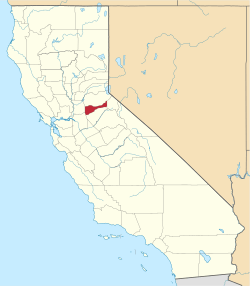 | |
| CDPs | ||
| Unincorporated communities | ||
| Ghost towns |
| |
| Footnotes | ‡This CDP also has portions in an adjacent county or counties | |