Polavaram Project
| Polavaram Dam | |
|---|---|
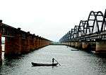
 Polavaram Right canal near Eluru | |
| Location | Polavaram, West Godavari District, Andhra Pradesh, India |
| Coordinates | 17°15′40″N 81°39′23″E / 17.26111°N 81.65639°ECoordinates: 17°15′40″N 81°39′23″E / 17.26111°N 81.65639°E |
| Purpose | Irrigation, Power |
| Status | under construction |
| Construction began | 2004 |
| Opening date | 2019.[1] |
| Operator(s) | Andhra Pradesh Irrigation Department |
| Dam and spillways | |
| Type of dam | Concrete spill way (754 m), Non over flow masonry dam (560 m) & Earth dam (1600 m) |
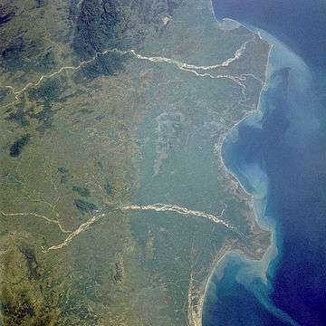
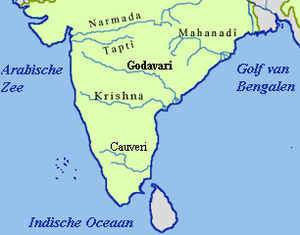
| Impounds | Godavari River |
| Height | 39.28 m (129 ft) up to top of earth dam above the lowest river bed. |
| Length | 2,914 m (9,560 ft) |
| Spillway type | Ogee section |
| Spillway capacity | 3,600,000 cusecs at 140 ft msl |
| Reservoir | |
| Creates | Polavaram Reservoir |
| Total capacity | 194 tmcft at FRL 150 ft msl |
| Active capacity | 175 tmcft (at 25.4 m msl crest level of spillway) |
| Inactive capacity | 19 tmcft (below 25.4 m msl) |
| Catchment area | 307,800 km2 (118,800 sq mi) |
| Surface area | 600 km2 (230 sq mi) |
| Max. water depth | 32.08 m at FRL 150 ft msl |
| Power station | |
| Operator(s) | APGENCO |
| Turbines | 12 × 80MW Francis-type (left bank side) |
| Installed capacity | 960 MW (under construction) |
Polavaram Project is a multi-purpose irrigation project which has been accorded national project status by the central government.[2][3] This dam across the Godavari River is under construction located in West Godavari District and East Godavari District in Andhra Pradesh state and its reservoir spreads in parts of Chhattisgarh and Odisha States also.[4]
Purpose

National River-Linking Project, which works under the aegis of the Indian Ministry of Water Resources, was designed to overcome the deficit in water in the country. As a part of this plan, surplus water from the Himalayan rivers is to be transferred to the peninsular rivers of India. This exercise, with a combined network of 30 river-links and a total length of 14,900 kilometres (9,300 mi) at an estimated cost of US$120 billion (in 1999), would be the largest ever infrastructure project in the world.[5] In this project's case, the Godavari river basin[6] is considered as a surplus one, while the Krishna River basin is considered to be a deficit one.[7] As of 2008, 644 tmcft of underutilised water from Godavari River flowed into the Bay of Bengal.[8] Based on the estimated water requirements in 2025, the Study recommended that sizeable surplus water was to be transferred from the Godavari River basin to the Krishna River basin.[7]
In July 1941, the first conceptual proposal for the project came from the erstwhile Madras Presidency. Later Diwan Bahadur L. Venkatakrishna Iyer, then chief engineer in the Presidency's irrigation department, made the first survey of the project site and made a definitive proposal for a reservoir at Polavaram. Sri Iyer not only visioned cultivation of 350,000 acres (140,000 ha) over two crop seasons through this project, but also planned for a 40 megawatt hydroelectric plant within the project. The entire project was estimated to cost about ₹65 million (US$970,000). The old final designs[9] of Polavaram dam was planned at full reservoir level (FRL) 208 ft MSL (Mean Sea Level) with 836 tmcft gross storage capacity and 150 MW hydroelectric plant. By 1946–47, the estimated cost rose to ₹1.29 billion. It was named the "Ramapada Sagar Project" since the backwaters of the reservoir would touch the Lord Rama temple at Bhadrachalam. In the old finalised project design by Dr. K.L. Rao, the right bank canal of Polavaram project was extended to south of Krishna River to serve irrigation needs in old Guntur district by envisaging aqueduct across the Krishna River.[10]
The project presently under construction is scaled down to FRL 150 feet (46 m) MSL. The project cost estimate in 2004 stood at ₹86.21 billion.[11]
In 1980, then Chief Minister of Andhra Pradesh T. Anjaiah laid the foundation stone for the project.The project is stalled till YSR Reddy in 2004 the then chief minister of AP took the project to work. YSR got the required permissions for the projects before he died.[12] for polavaram project, Site clearance was obtained from the Centre on 19 September 2005, environmental clearance on 25 October 2005, R & R clearance on 17 April 2007, wildlife sanctuary clearance on 19 Sept 2008, forest clearance on 26 Dec 26 2008 and technical advisory committee clearance on 20 January 2009. Progress of polavaram hit road block post YSR death.[13] later, Polavaram project is declared as national project through AP special re-org act in 2013.
Alternate site
The dam could not be taken up for construction during the last century on techno economical grounds. The proposed dam site at Polavaram is located where the river emerges from the last range of the Eastern Ghats into plains covered with deep alluvial sandy strata. At Polavaram, the river width is about 1500 m. In view of large depth of excavation which is more than 30 m deep, to reach hard rock at this dam site, the dam project was not found economical to take up. However a lucrative alternate site is feasible located in upstream of Polavaram site where the river passes through deep gorges of Papi hill range.[14] The width of river is about 300 m only in the rocky gorge stretch. Thirty years back, this alternative was found technologically challenging task to connect the reservoir with the irrigation canals via tunnels across the ghat area. Also costly underground hydro electric station is mandated compared to river bed based hydro electric station. When the project was actually taken up in the year 2004, the old finalised designs at Polavaram site are adopted without re-examining the latest cost of upstream alternate site in view of state of the art construction technology of tunnels and underground hydro electric station. The progress up to the year 2012 in construction of dam structures and the hydro electric station is almost nil.[15] The alternate site located in the gorge stretch is still worth of re-examination to reduce the ever increasing cost of Polavaran dam.
The spillway and non-overflow dam are founded on Khondalite bed rock in Polavaram Project.[14] Khondalites, which are feldspar-rich, often contain soft graphite, hard garnet, etc. in addition to other minerals. Khondalites are highly weathered and hence unsuitable at dam site.[16]
Technical details
The project reservoir has live storage 75.2 tmcft at canal's full supply level of 41.15 metres (135 ft) MSL and gross storage 194 tmcft thereby enabling irrigation of 23,20,000 acre (including stabilisation of existing irrigated lands) in Krishna, West Godavari, East Godavari, Visakhapatnam, Vizianagaram and Srikakulam districts of Andhra Pradesh.[11][17] The silt free dead storage water of nearly 100 tmcft above the spillway crest level 24.5 metres (80 ft) MSL, can also be used in downstream lift irrigation projects (Pattiseema lift, Tadipudi lift, Thorrigedda lift, Pushkara lift, Purushothapatnam lift, Venkatanagaram lift, Chagalnadu lift, etc.) and Dowleswaram Barrage during the summer months.[14][18][19] GoAP annonced the decision to construct Purushothapatnam lift irrigation scheme to transfer water at the rate of 3500 cusecs to Polavaram left bank canal and Yeleru reservoir to feed Yeleru canal which is supplying water to Vizag city.[20][21] All the irrigated lands under these lift schemes can be supplied from Polavaram right and left canals by gravity flow when Polavaram reservoir level is above the canal's full supply level of 41.15 m MSL. However these lift stations are to be operated every year during the dry season to draw water from the substantial dead storage available behind the flood gates of the Polavaram dam. So these lift schemes are not for few years operation till the Polavaram dam is constructed but for permanent operation regularly for at least four months in every year. Nearly 60 tmcft live storage capacity available to Andhra Pradesh in Sileru river basin can also augment the water availability additionally to the Polavaram project during the dry season.
The dam construction involves building of a 1.5 m thick concrete diaphragm wall up to depths from 40 to 120 m below the river bed under the earth dam which is first of its kind in India.[22] The purpose of diaphragm wall is to secure the river bed stability for withstanding the water pressure across the dam. The project would constitute an earth-cum-rock fill dam of 2,310 metres (7,580 ft) length, spillway of 907 metres (2,976 ft) with 44 vents to enable discharge of 3,600,000 cu ft/s (100,000 m3/s) of water. The spillway is located on the right bank of the river for which nearly 5.5 km long and 1.0 km wide approach and spill channels up to river bed level is envisaged involving nearly 70 million cubic meters earth/rock excavation which is nearly 2/3rd of the project's total earth work. The maximum flood level at Polavaram is 28 metres (92 ft) MSL and lowest water level is 10.9 metres (36 ft) MSL. A cofferdam is planned up to 41 metres (135 ft) MSL initially to facilitate faster pace of work on earth-cum-rock fill dam to complete the first phase of the project by June 2018.[23] With coffer dam inclusion and the bed level of the approach and discharge canals of the spillway increased to 17 metres (56 ft) MSL, the spillway related rock excavation is reduced by 70% leading to substantial cost reduction in the project's head works cost. Ultimately, the cofferdam would become peripheral portion of the main earth-cum-rock fill dam. On the left side of the river, 12 water turbines, each having 80 megawatt capacity, were to be installed. The right canal connecting to Krishna River in the upstream of Prakasam Barrage (173 kilometres (107 mi) long) discharges 17,500 cu ft/s (500 m3/s) at head works and left canal (182 kilometres (113 mi) long) discharges 17,500 cu ft/s (500 m3/s) of water.[11]
Indira Dummugudem lift irrigation scheme starting at 17°33′49″N 81°14′49″E / 17.56361°N 81.24694°E is under construction to supply irrigation water for 200,000 acres in Khammam, Krishna and West Godavari districts drawing Godavari River water from the back waters of Polavaram reservoir.[24] This is a joint project between Andhra Pradesh and Telangana states. This project was shelved and merged with another project by the Telangana state.
Interstate water sharing
As per the inter state agreements dated 4 August 1978 (page 89) and 29 January 1979 (page 101) with Andhra Pradesh, the states of Karnataka and Maharashtra are entitled to use 21 tmcft and 14 tmcft respectively out of the unallocated waters of Krishna river when Godavari water transferred in a year by Polavaram right bank canal from Polavaram reservoir to Prakasam barrage across Krishna river is not exceeding 80 tmcft at 75% dependability.[25][26] When additional Godavari water exceeding 80 tmcft is transferred from Polavaram reservoir, Karnataka and Maharashtra are entitled with additional water from the unallocated Krishna river waters in the same proportion (i.e. 21:14:45) provided all the following conditions are satisfied.
- The additional Godavari water from Polavaram project should be transferred to the Krishna river in the upstream of Prakasam barrage. Such additional Godavari water quantity to be shared is decided based on 75% dependability.
- The transferred water shall also displace the water discharges from Nagarjuna Sagar Dam for the Krishna delta requirements. Krishna delta is the area located down stream of Prakasam barrage which is part of Krishna basin.[27] It does not include adjacent coastal river basins which are being irrigated by the Krishna waters from the Prakasam barrage.
Thus Andhra Pradesh is entitled to transfer Godavari water in excess of 80 tmcft in three out of four years (below 75% dependability) reducing the water releases from Nagarjunasagar dam for Krishna delta requirements and need not share water with other states beyond 80 tmcft.
The above interstate water sharing agreement does not cover the Godavari water transferred to Krishna river which is not displacing the water releases from the Nagarjunasagar dam for the requirements of Krishna delta. Thus Andhra Pradesh need not share with other states the water transferred via Krishna river or any reservoir located on Krishna river for the water needs of any of its area (including Krishna basin) other than Krishna delta.
Godavari Penna River linking
A new lift at Singannagudem near 16°40′30″N 80°51′57″E to lift water from Polavaram Right Main Canal (from 35m MSL to 70m MSL) to a new contour canal of Bed Level 65m MSL can made possible of Godavari River and Penna River linking[28] including stabilisation of Nagarjuna Sagar Dam right canal ayacut. This 150 km long gravity canal will pass Wyra River, Munneru River and Krishna River and terminate at Ganapavaram near 16°25′22″N 80°02′17″E in Guntur District. A new dam with reversible turbines across near by hill range will pump the Godavari water into the new reservoir created by it. Thus it will store and use around 35TMC flood water of Godavari at it is at FRL 260m MSL. From this reservoir water will be released to Nagarjuna Sagar Right Main Canal at Nekarikallu through pipes.
There is a proposal to link Nagarjuna Sagar Dam across the Krishna River and Somasila Dam across Penna River with 400 km canal as part of national river linking program. With help from the Indian Government, AP Govt can construct a new canal up to Somasila Dam as per DPR of Indian Rivers Inter-link program specifications.[29] Thus the Godavari River water will travel up to Somasila Dam and then Swarnamukhi in Chittoor district via existing Somasila Swarnamukhi link canal. AP Govt can also provide water to Tamil Nadu from this Godavari water and retained water in Krishna River (15TMC allocation of Krishna water to Telugu Ganga) will be used for other projects in Rayalaseema region.
In future a new massive dam named Palnadu Sagar[30] across hill range near Karempudi with 700TMC capacity reservoir is possible using of flood water of Krishna River and Godavari River diverted via the contour canal. It will submerge 300Sq KM of land at FRL 260m MSL. Palnadu Sagar will receive Godavari River water from adjacent 260M FRL reservoir via siphon effect by using 25 km long pipe lines between them under the fields. Palnadu Sagar spillway with Francis Turbine will release water into Nagarjuna Sagar right canal along with Hydroelectricity power generation. Flood water of Krishna River will be pumped to Palnadu Sagar through Nagarjuna Sagar Canal with the help of reversible turbines. The water stored in Palnadu Sagar will be used for irrigation and drinking in drought years.
Future potential
A barrage would be constructed on Krishna river located near 16°34′41″N 80°24′43″E / 16.57806°N 80.41194°E in the upstream of Prakasam barrage with FRL at 24m MSL to receive Godavari water diverted from Polavaram dam.[31] This barrage would also enable a new road / bridge link diverting south bound road traffic from Hyderabad side on NH9 to Guntur district without touching Vijayawada city
A low level lift canal from the Krishna river located near 16°42′50″N 80°08′24″E / 16.71389°N 80.14000°E at 20 m MSL in the downstream of Pulichintala dam will be executed to feed Godavari water diverted from Polavaram Dam to some of the existing command area (situated below 60 m MSL) under Nagarjuna Sagar right bank canal to facilitate extension of Nagarjuna Sagar right bank canal connecting to Kandaleru feeder canal / Somasila reservoir for serving irrigation needs in Prakasam, Potti Sriramulu Nellore and Chittur districts including Chennai drinking water supply. A branch from this lift canal is also extended up to Pulichinthala dam (FRL 53.34 m MSL) to store Godavari water in Pulichintala reservoir during drought years and to irrigate low lands along Krishna river up to Pulichintala dam.
Another high level lift canal from above Krishna river location 16°42′50″N 80°08′24″E / 16.71389°N 80.14000°E up to 90 m MSL would be constructed to join Nagarjuna Sagar tail pond (FRL 75 m MSL) irrigating lands en route along Krishna river in Guntur district. During drought years, the water transferred by this canal to Nagarjuna Sagar tail pond is further lifted to Nagarjuna Sagar and Srisailam reservoirs with the existing pumped storage hydro units for use in all the projects receiving water from these reservoirs. This high level lift canal is an alternative to Dummugudem to Sagar lift canal planned in Telangana region which would transfer Godavari river water from Dummugudem to Nagarjuna Sagar tail pond.
Another lift canal drawing water from the Polavaram right bank canal near 16°38′20″N 80°37′53″E / 16.63889°N 80.63139°E at 30 m MSL would be constructed by pumping water in stages up to 120 m MSL to supply water to the existing command area of Nagarjunasagar left bank canal and irrigate uplands in Krishna district up to Pulichintala dam. It would save nearly 40 tmcft of Krishna water which can be diverted to Rayalaseema needs from Srisailam reservoir. All these pumping stations can be envisaged with high level ponds to incorporate peaking electricity generation capability to achieve multi purpose benefits. Ultimately the Polavaram right bank canal would be remodelled to enhance its capacity to 30,000 cusecs by raising its embankments for augmenting water transfer to meet shortages in the Krishna river basin and the needed environmental flows downstream of Prakasam barrage. Refer to Google Earth data for more geographical information.
A 25 MW hydropower station can be established utilising Polavaram right bank canal water near Vijayawada city by transferring water via Budameru river and Eluru canal to Prakasam barrage pond.
A lift canal starting at 175m MSL receiving water from Polavaram reservoir, would irrigate most of the high lands in West Godavari and Krishna districts including the area presently cultivated by Nagarjunasagar left bank canal. This canal originating from a new balancing reservoir located near 17°14′43″N 81°27′57″E / 17.24528°N 81.46583°E in Eastern Ghats area, will be connected to the Polavaram reservoir with a fore shore pump house to lift the water by 150 meters to feed in to a fifteen (15) km long tunnel across the Eastern Ghats. The balancing reservoir intended to store the flood waters of Godavari river, would also serve as the upper pond for using the pumping station as peaking hydro power station.
Off shore fresh water reservoir
An off shore fresh water storage reservoir of capacity 700 Tmcft could be constructed along the sea coast of Chirala to store the Krishna & Godavari river flood waters for creating additional irrigated area in Prakasam, Potti Sriramulu Nellore, Cudapah, Chittoor districts and further transfer of Godavari water to Kavery river in Tamil Nadu under interstate rivers linking project. This project is similar to Kalpasar Project to store Narmada River water in Gulf of Khambhat sea.
Fresh water reservoirs can be established in the shallow sea area by constructing sea dikes / bunds/ Causeway up to the depth of 20 meters from the coast line. Water can be pumped from this artificial fresh water lagoon throughout the year for meeting agriculture, etc. needs. Also top surface of this dike can be used as coastal road & rail rout. The proposed dikes would be similar to the land reclamation of North Sea area called Delta Works in Netherlands or Saemangeum Seawall in South Korea. This project with 20 meters average depth is lesser challenging technically when compared to Saemangeum Seawall project which is having 36 meters average water depth.
The sea area up to 20 meters depth adjacent to coast line between the locations (near 15°46′31″N 80°48′45″E / 15.77528°N 80.81250°E) where southern branch of the Krishna river is joining the sea and the mouth of the Gundlakamma River (near 15°33′23″N 80°13′37″E / 15.55639°N 80.22694°E), is highly suitable for creating the off shore fresh water reservoir. The width of the sea up to 20 m depth is nearly 30 km wide and the required length of the sea dikes is nearly 70 km. The area of the off shore reservoir would be nearly 2000 km2. A barrage would be constructed across the Krishna river (near 16°04′41″N 80°52′49″E / 16.07806°N 80.88028°E) near Mopidevi town. A flood canal (25 km long) from this barrage would feed Krishna river water to the off shore water reservoir. A flood canal from Dowleswaram Barrage would also connect by gravity to this proposed barrage to feed Godavari water to the off shore fresh water reservoir. The off shore dike extending up to 8 m msl high, would also reduce drastically the cyclone damage and flooding in Chirala, Bapatla and Nizampatnam coastal areas. It would also greatly improve the irrigated coastal lands drainage in Guntur and Prakasam districts. The sea dike can also serve as an access way to a major deep sea port which can be located on the deep sea side of the 70 km long dike.Locks arrangement (similar to Panama canal) would be provided for the movement of ships from the open sea in to the fresh water reservoir. This reservoir area can also be used for shipping, ship breaking, ship building, etc. purposes. Part of the fresh water reservoir area can also be used for locating floating solar power plants to generate the needed water pumping power.[32] Nearly 1100 tmcft water of Godavari and Krishna flood waters can be utilised for irrigation, etc. requirements with this off shore fresh water reservoir.
Vast lands in the districts of Prakasam, Nellore, Cudapah and Chittoor are drought prone and do not have adequate water sources for irrigating the dry lands.[33] Water from this off shore fresh water reservoir would be pumped uplands to Ramathirtham water tank (near 15°37′37″N 79°48′47″E / 15.62694°N 79.81306°E) which is at 85 m msl.[34] From this water tank, dry lands in Prakasam and Nellore districts up to Tamil Nadu boarder can be brought under irrigation by gravity canals. From this canal, water would be further pumped to the uplands of Chittoor and Cudapah districts up to 600 m msl across the Seshachalam mountains. This canal would also be extended with lifts to transfer 350 tmcft water up to the Kavery river in Tamil Nadu state during South-west monsoon period. The total cost to Andhra Pradesh state would be less than Rs 300 billions which is nearly Rs 1,00,000 per acre of irrigated land.
Controversies
The proposed project would displace 276 villages and 44,574 families spread across Andhra Pradesh state mainly. Tribals constitute 50% of such a displaced population.[35] Human rights activists came out against the project because of these reasons. In addition, one activist pointed out that this interlinking of the rivers will harm the interests of the region in the state.[36] Environmental activist Medha Patkar said that the project not only will displace several thousands of families, it will also submerge several archaeological sites, coal deposits, a wildlife sanctuary and several hectares of farm land.[37]
Sixty-four years after the initial conception of the project, the Government of Andhra Pradesh secured the environmental clearance from the central agency in 2005. This clearance was obtained after the state government prepared a ₹4,500 crore forest management plan and rehabilitation and resettlement proposal covering 59,756 hectares that were being lost under the project. In addition, ₹40,000 was to be allotted for each dwelling to be constructed for the displaced as against ₹25,000 provided by other states.[38] Despite this clearance, the project faced political roadblocks. The Communist Party of India (M) and Telangana Rashtra Samithi were troubled with the issue of submerging agricultural lands by the project.[39][40]
Meanwhile, work on the project began in April 2006 and was expected to be completed by February 2007.[41] After 30% work of excavation work on the canals and 15% of the spillway works had been completed, the work was halted in May 2006 to seek clearance from the Ministry of Forests and Environment.[42]
The neighbouring state of Odisha also expressed its concern on the submerging of its land and decided to study this together with the officials from Andhra Pradesh.[43] In response, Chief Minister of Andhra Pradesh Late Y. S. Rajasekhara Reddy clarified that neither Odisha nor Chhattisgarh would be affected by the construction.[44] The problem continued until 2010, when Chief Minister of Odisha Naveen Patnaik remained steadfast in his demand for compensation and rehabilitation of tribals of his state who would be displaced due to the submerging of their land.[45]
Odisha and Chhattisgarh have filed a petition in the Supreme Court against the Project which has probability of temporarily submerging large areas of its state and allege that union government are going ahead with the project without the necessary permissions from Environment Ministry. Under section 90 of the Andhra Pradesh Reorganisation Act, 2014, union government has taken the responsibility of taking all clearances and approvals for the project execution and also declared the project as national project.[46] The states also allege that public hearing in the effected areas are not held. Under section 90 (3) of the Andhra Pradesh Reorganisation Act, 2014, Telangana state has already given the approval in all respects to the Polavaram project.[46][47]
Interstate river water disputes
Odisha, Chhattisgarh and Andhra Pradesh entered into agreement (clause vi of final order, page 80 of original GWDT) which were made part of Godavari Water Disputes Tribunal (GWDT) award.[26] The agreement allows Andhra Pradesh to construct the Polavaram reservoir with full reservoir level (FRL) at 150 feet above the mean sea level (MSL). Odisha approached Supreme Court against the design discharge capacity of the Polavaram dam spill way stating that it should be designed for five million cusecs (cubic feet per second) which is the estimated probable maximum flood (PMF) once in 1000 years duration. Odisha argues that otherwise there would be additional submergence above 150 ft MSL in its territory during peak floods. The recorded maximum flood is 3.0 million cusecs in the year 1986 during last 115 years.[10][48]
The projected back water level build up at Konta due to PMF in Godavari river after construction of Polavaram project with designed maximum water level (measured at dam point) shall be cross checked with the level that can occur at Konta in Sabari basin from the PMF generated in the upstream of Konta when the downstream main Godavari is not under spate. Then only enhanced submergence during the PMF of Godavari river in Odisha and Chhattisgarh states can be assessed due to Polavaram dam construction.
The location of Polavaram dam is in the plain area at approximately 10 km downstream from the 50 km long narrow gorge in the Papi Hills. It is also to be ascertained whether the higher back water level during the PMF in Godavari river is solely due to the presence of long narrow gorge which is acting as a natural dam / barrier or further enhanced by the presence of downstream Polavaram barrage.
It is purely an academic interest showing concern for the few thousand hectares of farm/forest land submerged by the back water level build up once in five hundred or thousand years without showing concern for the thousands of square kilometres land submerged in the area downstream of the dam with a river flood of magnitude five million cusecs.
Thirty two years have passed after GWDT award in 1980, Maharashtra, Odisha and Chhattisgarh have not made serious efforts to harness the major Godavari tributaries such as Sabari River, Indravati River and Pranahita River to utilise the allocated share of Godavari waters. This underutilisation of water is the main reason for the very high flood flows at Polavaram dam site. Vast area in excess of 10,000 square km up to sea are frequently flooded (at least once in a decade) by Godavari floods in Andhra Pradesh by the flood waters originated in Madhya Pradesh, Maharashtra, Odisha and Chhattisgarh states. The land submergence due to Polavaram dam in Odisha and Chhattisgarh states is fraction of Andhra Pradesh area which is affected by the floods in Godavari River. During the years from 1953 to 2011, Andhra Pradesh suffered nearly 558 billion rupees which is 26% of total flood damage in India.[49] It is justified to raise the FRL of Polavaram dam further on this ground alone. One single criterion shall be applied by the tribunals / courts for all the submerged lands whether they are related to reservoir projects construction or due to river floods (i.e. non-utilisation of river water). Upstream states shall not take granted that downstream state areas are permitted to be flooded /inundated by the river flood water without offering agreeable relief / comforts.
Odisha and Chhattisgarh entered into agreement (clause 3e, Annexure F, Page 159 of original GWDT) to construct a Hydro electricity project at Konta / Motu just upstream of the confluence point of Sileru tributary with Sabari River (tri-junction point of Andhra Pradesh, Odisha and Chhattisgarh borders).[50] When this project is constructed, the land submergence would be more than that of Polavaram back waters. It would be better that Odisha and Chhattisgarh enter into agreement with Andhra Pradesh to shift the location of this Hydro electricity project further down stream in Andhra Pradesh territory to harness Sileru river water also for hydro electricity generation. This joint project of the three states would eliminate the back waters issue of Polavaram dam.
The 200 km long stretch of the Sabari river forming boundary between Chhattisgarh and Odisha drops by 2.25 meters per km length on average. This stretch of the river has substantial hydro electricity generation potential by building medium head (< 20 m) barrages in series to minimise land submergence.[51] The surplus water of Indravati River in Odisha can also be diverted to Sabari river via Jaura Nala through which Indravati River waters naturally overflow into Sabari basin.[52]
See also
References
- ↑ http://www.andhrajyothy.com/Artical?SID=223261
- ↑ "List of national projects," (PDF). Retrieved 17 March 2016.
- ↑ "Indirasagar (Polavaram) Project, Ministry of water resources, GoI". Retrieved 17 December 2013.
- ↑ "Agitation against Polavaram, SANDRP" (PDF). Retrieved 7 May 2014.
- ↑ L., Bharati; V. U. Smakhtin; B. K. Anand (2009). "Modeling water supply and demand scenarios: the Godavari-krishna inter-basin transfer, India" (PDF). Water Policy. 11: 140. doi:10.2166/wp.2009.109. Retrieved 7 August 2013.
- ↑ "Godavari river basin map"
- 1 2 Luna, Bharati; B. K. Anand; Vladmir Smakhtin (2009). "Analysis of the Inter-basin Water Transfer Scheme in India: A Case Study of the Godavari-Krishna Link". Strategic Analysis of the National River Linking Project (NRLP) on India. 5: 63–78. Retrieved 4 November 2010.
- ↑ Amarasinghe, Upali A.; Sharma, Bharat R. (2008). "Benefits of Irrigation Water Transfer in the National River Linking Project: A Case Study of the Godavari (Polavaram)-Krishna Link in Andhra Pradesh". Strategic Analysis of the National River Linking Project (NRLP) on India. 2: 173–193. Retrieved 4 November 2010.
- ↑ Gujja, Biksham (2006). Perspectives on Polavaram, a major irrigation project on Godavari. Academic Foundation. pp. 17–19. ISBN 81-7188-578-0. https://books.google.com/books?id=HSnDO8Nlj2IC&lpg=PP1&dq=Perspectives%20on%20Polavaram%2C%20a%20major%20irrigation%20project%20on%20Godavari&pg=PP1#v=onepage&q&f=false.
- 1 2 "Detailed report on Polavaram Project, GoAP". Retrieved 17 June 2014.
- 1 2 3 "YSR performs bhoomi pooja for Polavaram project". The Financial Express. 9 November 2004. Retrieved 4 November 2010.
- ↑ "YSR set 3yr dead line". The Indian express. 2 March 2009. Retrieved 2 March 2009.
- ↑ "YSR death setback polavaram". The Hindu. 10 March 2010. Retrieved 10 March 2010.
- 1 2 3 "Salient design data of Polavaram project, National Water Development Authority, GoI" (PDF). Retrieved 17 February 2013.
- ↑ "Irrigation projects status in Andhra Pradesh, AP Govt.". Retrieved 1 October 2013.
- ↑ "Engineering Geology of dams; by Siva Bharatha Murthy . T" (PDF). Retrieved 17 February 2013.
- ↑ "Indirasagar (Polavaram) Project reservoir, Ministry of water resources, GoI" (PDF). Retrieved 7 May 2014.
- ↑ "Pattiseema project advanced". Retrieved 17 November 2015.
- ↑ "Tadipudi Lift Station L00054". Retrieved 19 July 2015.
- ↑ "Polavaram will be ready by 2018, says Devineni". Retrieved 17 October 2016.
- ↑ "State Government to Start Purushothapatnam Lift Scheme, on the Lines of Pattiseema". Retrieved 16 October 2016.
- ↑ "L&T Geostructure-Bauer Joint Venture has secured an order worth 422 crores" (PDF). Retrieved 7 January 2016.
- ↑ "Cofferdam allows water into canals ahead of completion". Retrieved 20 September 2016.
- ↑ "Refer ongoing major projects, Indira Dummugudem lift irrigation". Retrieved 19 July 2015.
- ↑ "GWDT Award" (PDF). Government of India. Retrieved 21 March 2015.
- 1 2 "Godavari Water Disputes Tribunal final report, page 52"
- ↑ "Lower Krishna basin watershed map" (PDF). Retrieved 21 March 2016.
- ↑ "Clipping of Andhra Jyothy Telugu Daily - Andhra Pradesh". Retrieved 2016-10-04.
- ↑ "Welcome To NWDA". nwda.gov.in. Retrieved 2016-10-04.
- ↑ "Clipping of Andhra Jyothy Telugu Daily - Andhra Pradesh". Retrieved 2016-10-04.
- ↑ "New barrage between Pulichintala dam and Prakasam barrage across Krishna river". Retrieved 11 January 2016.
- ↑ "Green Power Island: A blue battery for green energy". Retrieved July 13, 2015.
- ↑ Brown, Lester R. (November 29, 2013). "India's dangerous 'food bubble'". Los Angeles Times. Archived from the original on December 4, 2013. Retrieved July 13, 2014.
- ↑ "Ramathirtham Dam D06139". Retrieved 13 October 2015.
- ↑ S., Laxman Rao; Priya Deshingkar; John Farrington (30 December 2006). "Tribal Land Alienation in Andhra Pradesh" (PDF). Economic and Political Weekly: 5401–5407. Retrieved 4 November 2010.
- ↑ "Polavaram project will spell doom for tribals: Human Rights Forum". The Hindu Business Line. 19 May 2005. Retrieved 4 November 2010.
- ↑ "Green signal for Polavaram dam". The Times of India. 25 October 2005. Retrieved 4 November 2010.
- ↑ "Polavaram project gets clearance". The Hindu. 26 October 2005. Retrieved 4 November 2010.
- ↑ "TRS stalls Assembly over Polavaram". The Times of India. 17 February 2006. Retrieved 4 November 2010.
- ↑ "CPI(M) plans Chalo Assembly on Polavaram". The Hindu. 9 February 2006. Retrieved 4 November 2010.
- ↑ G. V., Ramana Rao (8 April 2006). "Work on Polavaram project in full swing". The Hindu. Retrieved 4 November 2010.
- ↑ G., Nagaraja (18 May 2006). "Polavaram project works come to a grinding halt again". The Hindu. Retrieved 4 November 2010.
- ↑ "Orissa for joint survey on Polavaram project". The Hindu. 15 November 2006. Retrieved 4 November 2010.
- ↑ "Polavaram: no submergence in other States". The Hindu. 28 March 2007. Retrieved 4 November 2010.
- ↑ "Polavaram dam: Andhra vs Orissa". NDTV. 4 November 2010. Retrieved 4 November 2010.
- 1 2 Ministry of Law and Justice (1 March 2014). "The Andhra Pradesh Reorganisation Act, 2014, 6 of 2014" (PDF). Retrieved 12 July 2016.
- ↑ "The Andhra Pradesh Reorganisation (Amendment) Act, 2014" (PDF). 17 July 2014. Retrieved 1 August 2014.
- ↑ "Water flow data at Polavaram". Retrieved 26 May 2014.
- ↑ "State wise flood damage statistics in India" (PDF). Retrieved 4 January 2013.
- ↑ "24 MW Sukuma Hydro Project near Konta". Retrieved 29 April 2013.
- ↑ "Middle Kolab (25 MW) and Lower Kolab (12 MW) hydro power stations". Retrieved 4 January 2015.
- ↑ "Jaura Nala natural interconnection between Indravati and Kolab rivers" (PDF). Retrieved 4 January 2015.
| Rivers |
|    | |||||||||||||||||||||||||
|---|---|---|---|---|---|---|---|---|---|---|---|---|---|---|---|---|---|---|---|---|---|---|---|---|---|---|---|
| Dams, barrages | |||||||||||||||||||||||||||
| Geographical features / regions | |||||||||||||||||||||||||||
| Riparian districts |
| ||||||||||||||||||||||||||
| Cities | |||||||||||||||||||||||||||
| Languages / people | |||||||||||||||||||||||||||
| Coalfields | |||||||||||||||||||||||||||
| Oil / gas fields | |||||||||||||||||||||||||||
| Industries |
| ||||||||||||||||||||||||||
| Transport | |||||||||||||||||||||||||||
| Related topics | |||||||||||||||||||||||||||
| Other basins | |||||||||||||||||||||||||||
|