Port Noarlunga, South Australia
| Port Noarlunga Adelaide, South Australia | |||||||||||||
|---|---|---|---|---|---|---|---|---|---|---|---|---|---|
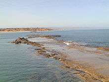
.jpg) Port Noarlunga jetty and reef, viewed from Witton Bluff | |||||||||||||
 Port Noarlunga | |||||||||||||
| Coordinates | 35°08′51″S 138°28′36″E / 35.14755°S 138.476570°ECoordinates: 35°08′51″S 138°28′36″E / 35.14755°S 138.476570°E | ||||||||||||
| Population | 2,632 (2011 census)[1] | ||||||||||||
| Established | 1856[2] | ||||||||||||
| Postcode(s) | 5167[3] | ||||||||||||
| Location | 27 km (17 mi) south of Adelaide | ||||||||||||
| LGA(s) | City of Onkaparinga | ||||||||||||
| State electorate(s) | Kaurna[4] | ||||||||||||
| Federal Division(s) | Kingston[5] | ||||||||||||
| |||||||||||||
| |||||||||||||
| Footnotes |
Coordinates[2] Location[3] Climate[6] Adjoining suburbs[2] | ||||||||||||
Port Noarlunga is a suburb in the City of Onkaparinga, South Australia. It is a small sea-side suburb, population 2,632,[1] about 30 kilometres (19 mi) to the south of the Adelaide city centre and was originally created as a sea port. This area is now popular as a holiday destination or for permanent residents wishing to commute to Adelaide or work locally. There is a jetty that connects to a 1.6 kilometres (0.99 mi) long natural reef that is exposed at low tide. The beach is large and very long and has reasonable surfing in the South Port area whose name is taken from its location - 'South of the Port'.[7]
The suburb is bounded to the south by the Onkaparinga River, including a tidal estuary. It is bounded to the west by the coastline with Gulf St Vincent, by Christies Beach to the north and by Noarlunga Centre and Noarlunga Downs to the east.[2]
History
In pre-European times, this area along with most of the Adelaide plains was inhabited by the Kaurna tribe.
The first record of the area was provided by Captain Collet Barker who explored the Onkaparinga River on 15 April 1831 in his search for a Gulf outlet from Lake Alexandrina. In early 1837, while camped by the Sturt River near Marion, South Australia's only two horses slipped their tether ropes during the night and the overseer of stock, C.W. Stuart led an expedition to recover them. Taking a botanist to record the plants encountered, the expedition searched much of present-day Noarlunga before finding the horses near the Onkaparinga River. The men being on foot were however, unable to capture them. In June 1837, Colonel William Light led an overland expedition to arrest whalers who had been abducting native women at Encounter Bay, 100 km south of Adelaide. Cresting Tapleys Hill they named the valley Morphett Vale after expedition member John Morphett. They reached the southern end of the Mount Lofty Ranges before impenetrable scrub forced them to return to Adelaide. The following year, John McLaren of the Survey Dept. divided the area south of Adelaide into three districts (B.C and D) based on the reports made by the Stuart and Light expeditions. B and C districts, the present Noarlunga District, was opened to public selection in February 1839 and by 1841 the population was estimated to be about 150.[8] The government town of Port Noarlunga was surveyed and offered for sale on 14 April 1859.[7]
The township was originally settled as a port for the produce from the proposed market town of Noarlunga a few kilometres upstream. The Onkaparinga River mouth proved unsuitable to coastal ketches, so produce was barged down river to the sandhills and then taken by horse drawn rail trucks to the jetty. The current jetty was constructed in 1921 and is the second jetty to have been constructed at Port Noarlunga. The original jetty, 30 metres south of the current jetty, was constructed in 1855, but was destroyed in several severe storms in the early 1900s.[7]
In the early 20th century Port Noarlunga was a popular coastal holiday destination, with the beach proving an attraction with its natural beauty and in summer amusement fairs were run, as well as row boating on the river estuary. Port Noarlunga Post Office opened around November 1909.[9]
With the gradual incursion of urban sprawl, and in particular immigration-fuelled expansion in the 1960s and 1970s, the township eventually became an outer suburb of Adelaide. The South Australian Housing Trust in particular developed housing in the nearby areas of Christies Beach and O'Sullivan Beach and with the extension of the metropolitan rail line to adjacent Noarlunga Centre in 1978 the township of Port Noarlunga had largely lost its attraction as a holiday destination.
It is now largely occupied by permanent residents, although it still retains much of its early village charm. The City of Onkaparinga council has assisted with maintaining this spirit of the old township, working with the State government in the late 1990s to divert through road traffic around the town centre.
State heritage places
The following places within Port Noarlunga are listed as ‘state heritage places’ on the South Australian Heritage Register:
- Perry Homestead, 80 Murray Road.[10]
- Dwelling and outbuildings, 53 Old Honeypot Road. [11]
- Port Noarlunga Hotel, 29 Saltfleet Street.[12]
- Sauerbier's House, 21 Wearing Street. [13]
Attractions

Beach and jetty
The beach and the jetty are the biggest attractions to visitors. The close proximity of a diverse range of aquatic features making this area stand out from other coastal locations. There is also a small main street (Gawler Street) that serves visitors and locals in this beach area. It has several cafes, a pub, a fish and chip shop, a surf shop and several other businesses providing services to the locals. The old "Institute" building, built in 1924, is now the community centre.
Port Noarlunga Reef
Port Noarlunga Reef is a narrow reef about 400 metres (1,300 ft) offshore and about 1.6 kilometres (0.99 mi) long and was formed from a consolidated Pleistocene sand dune. The reef runs parallel to shore and has two sections, with the area separating them called The Gap. It is a popular scuba diving and snorkelling location, with more than 200 marine plant species and over 60 fish species. There is a self-guided diving trail which was established in 1994, which is marked with a series of 12 glass plaques. The plaques indicate aspects of the reef ecosystem relevant to their location.[14]
Port Noarlunga Reef Aquatic Reserve
The Port Noarlunga Reef Aquatic Reserve is one of six aquatic reserves proclaimed in South Australia in 1971 with it being established specifically to protect the reef life and the adjacent river estuary.[15] The boundaries of the reserve were extended to the north in 1993 to include an adjacent limestone reef known as Horseshoe Reef at Christies Beach. As of 2007, it extends along the coastline from Onkaparinga Head at Port Noarlunga South in the south to Gulfview Road at Christies Beach in the north and includes the Onkaparinga River up until the Main South Road at Old Noarlunga. The reserve covers an area of 527 hectares (1,300 acres). Fishing activity is limited to the use of rod and handline while the use of ‘hand nets for the taking of shrimps for bait only’ is permitted in estuary and the Onkaparinga River. No fishing is permitted within 25 metres (82 ft) of Horseshoe and Port Noarlunga Reefs and can only be carried out from the jetty and the beach at Port Noarlunga.[14][16][17]
Port Noarlunga Aquatic Centre
Since 1976 the Port Noarlunga Aquatic Centre has operated classes for primary school children from throughout the state. The program runs in the first and last school terms each year and provides the opportunity to try waveskiing, canoeing, fishing, snorkelling, sailing, swimming and sailboarding. About 15,000 students have access to this program each year.[7]
Protected area status
Port Noarlunga includes parts of the following protected areas. The Encounter Marine Park and the Port Noarlunga Reef Aquatic Reserve both occupy land within the intertidal zone of the suburb along the coastline with Gulf St Vincent and the Onkaparinga River. The Encounter Marine Park also occupies the undeveloped area in the south of the suburb adjoining the mouth of the Onkaparinga River. [18][19]
See also
Notes and references
Notes
- 1 2 "Port Noarlunga Code SSC40595 (SSC)". ABS. Retrieved 9 October 2014.
- 1 2 3 4 "Search result for "Port Noarlunga (Suburb)" (Record no. SA0040637) with the following layers selected - "Suburbs and Localities" and " Place names (gazetteer)"". Property Location Browser. Government of South Australia. Retrieved 11 October 2016.
- 1 2 "Port Noarlunga, South Australia (Postcode)". postcodes-australia.com. Retrieved 11 October 2016.
- ↑ "Electoral district of Kaurna, 2014 State election boundaries". ELECTORAL COMMISSION SA. Retrieved 11 October 2016.
- ↑ "Map of the Federal division of Kingston" (PDF). Australian Electoral Commission. 2011. Retrieved 28 July 2015.
- ↑ "Monthly climate statistics: Summary statistics Noarlunga (nearest weather station)". Commonwealth of Australia , Bureau of Meteorology. Retrieved 11 October 2016.
- 1 2 3 4 Martella, L: "Port Noarlunga An Endearing Coastal Town". Lita Martella, 2000
- ↑ David J. Towler A Fortunate Locality-History of Noarlunga and Districts Published for the City of Noarlunga by Peacock Publications 1986 ISBN 0-909209-11-1
- ↑ Premier Postal History. "Post Office List". Premier Postal Auctions. Retrieved 26 May 2011.
- ↑ "Perry Homestead". South Australian Heritage Register. Department of Environment, Water and Natural Resources. Retrieved 1 November 2016.
- ↑ "Dwelling & Outbuildings". South Australian Heritage Register. Department of Environment, Water and Natural Resources. Retrieved 1 November 2016.
- ↑ "Port Noarlunga Hotel (former Milliari Guest House only - incorporated in hotel in 1933)". South Australian Heritage Register. Department of Environment, Water and Natural Resources. Retrieved 1 November 2016.
- ↑ "Dwelling ("Sauerbier's House") and Storage Shed/Privy". South Australian Heritage Register. Department of Environment, Water and Natural Resources. Retrieved 1 November 2016.
- 1 2 "Port Noarlunga Reef Underwater Trail" (PDF). Department of Primary Industries and Regions SA (PIRSA). Retrieved 9 October 2014.
- ↑ "Aquatic Reserves (as part of the proclamation of the Fisheries Act 1971)" (PDF). South Australian Government Gazette. Government of South Australia. 30 November 1971. pp. 2263 – 2264. Retrieved 12 November 2016.
- ↑ "Aquatic Reserves - Port Noarlunga" (PDF). PIRSA Fisheries. Retrieved 9 October 2014.
- ↑ "Summary of SA Marine Protected Areas by Type (see 'SA Reserve List' tab)". Australian Government - Department of the Environment. 10 February 2003. Retrieved 5 October 2014.
- ↑ "Search result for "Port Noarlunga, sub" with the following databases selected - "Suburbs and Localities", "Aquatic Reserves" and "State Marine Park Network "". Location SA Viewer. Government of South Australia. Retrieved 12 November 2016.
- ↑ "Encounter Marine Park" (PDF). Enjoy life in our marine parks. Government of South Australia. Retrieved 13 November 2016.
References
- Martella, Lita. Port Noarlunga An Endearing Coastal Town. Australia: Lita Martella. ISBN 0-646-40222-6.
- Onkaparinga Estuary Information Package Accessed 5 March 2013.
- Postcards profile