Powell, Wyoming
| Powell, Wyoming | |
|---|---|
| City | |
|
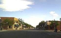
Downtown Powell, Wyoming, July 2015 | |
 Location of Powell, Wyoming | |
 Powell, Wyoming Location in the United States | |
| Coordinates: 44°45′32″N 108°45′30″W / 44.75889°N 108.75833°WCoordinates: 44°45′32″N 108°45′30″W / 44.75889°N 108.75833°W | |
| Country | United States |
| State | Wyoming |
| County | Park |
| Area[1] | |
| • Total | 4.25 sq mi (11.01 km2) |
| • Land | 4.25 sq mi (11.01 km2) |
| • Water | 0 sq mi (0 km2) |
| Elevation | 4,393 ft (1,339 m) |
| Population (2010)[2] | |
| • Total | 6,314 |
| • Estimate (2012[3]) | 6,308 |
| • Density | 1,485.6/sq mi (573.6/km2) |
| Time zone | Mountain (MST) (UTC-7) |
| • Summer (DST) | MDT (UTC-6) |
| ZIP code | 82435 |
| Area code(s) | 307 |
| FIPS code | 56-62450[4] |
| GNIS feature ID | 1609143[5] |
| Website | Official website |
Powell is a city in Park County, Wyoming, United States. The population was 6,314 at the 2010 census. Powell is an All-America City and home to Northwest College.
History
Powell was incorporated in 1909.[6] Powell was named for John Wesley Powell, U.S. soldier, geologist and explorer.[7] Powell post office was established January 23, 1908.[8]
In 2013, the area was the subject of a piece of national legislation. The Powell Shooting Range Land Conveyance Act (S. 130; 113th Congress), which was passed by both the United States Senate and the United States House of Representatives, would transfer a piece of land from the Bureau of Land Management to the Powell Recreation District for continued use as a shooting range.[9][10]
Geography
According to the United States Census Bureau, the city has a total area of 4.25 square miles (11.01 km2), all of it land.[1]
Powell experiences a desert climate (Köppen BWk) with cold, dry winters and hot, slightly wetter summers.
| Climate data for Powell Field Station | |||||||||||||
|---|---|---|---|---|---|---|---|---|---|---|---|---|---|
| Month | Jan | Feb | Mar | Apr | May | Jun | Jul | Aug | Sep | Oct | Nov | Dec | Year |
| Record high °F (°C) | 58 (14) |
69 (21) |
77 (25) |
85 (29) |
93 (34) |
99 (37) |
104 (40) |
102 (39) |
95 (35) |
87 (31) |
75 (24) |
66 (19) |
104 (40) |
| Average high °F (°C) | 29.8 (−1.2) |
37.3 (2.9) |
47.6 (8.7) |
57.8 (14.3) |
67.1 (19.5) |
77.0 (25) |
84.2 (29) |
83.8 (28.8) |
71.6 (22) |
58.8 (14.9) |
42.4 (5.8) |
32.7 (0.4) |
57.51 (14.18) |
| Daily mean °F (°C) | 17.8 (−7.9) |
24.9 (−3.9) |
34.5 (1.4) |
43.9 (6.6) |
54.1 (12.3) |
62.7 (17.1) |
68.6 (20.3) |
67.3 (19.6) |
56.1 (13.4) |
44.1 (6.7) |
30.0 (−1.1) |
20.4 (−6.4) |
43.7 (6.51) |
| Average low °F (°C) | 5.7 (−14.6) |
12.4 (−10.9) |
21.3 (−5.9) |
30.0 (−1.1) |
41.0 (5) |
48.4 (9.1) |
53.0 (11.7) |
50.7 (10.4) |
40.5 (4.7) |
29.4 (−1.4) |
17.6 (−8) |
8.1 (−13.3) |
29.84 (−1.19) |
| Record low °F (°C) | −27 (−33) |
−33 (−36) |
−15 (−26) |
4 (−16) |
19 (−7) |
32 (0) |
32 (0) |
33 (1) |
16 (−9) |
−5 (−21) |
−18 (−28) |
−34 (−37) |
−34 (−37) |
| Average precipitation inches (mm) | 0.20 (5.1) |
0.10 (2.5) |
0.31 (7.9) |
0.50 (12.7) |
1.42 (36.1) |
1.32 (33.5) |
1.00 (25.4) |
0.52 (13.2) |
0.70 (17.8) |
0.54 (13.7) |
0.19 (4.8) |
0.16 (4.1) |
6.96 (176.8) |
| Source #1: NOAA (normals, 1971–2000)[11] | |||||||||||||
| Source #2: The Weather Channel (Records)[12] | |||||||||||||
Demographics
| Historical population | |||
|---|---|---|---|
| Census | Pop. | %± | |
| 1920 | 2,463 | — | |
| 1930 | 1,156 | −53.1% | |
| 1940 | 1,948 | 68.5% | |
| 1950 | 3,804 | 95.3% | |
| 1960 | 4,740 | 24.6% | |
| 1970 | 4,807 | 1.4% | |
| 1980 | 5,310 | 10.5% | |
| 1990 | 5,292 | −0.3% | |
| 2000 | 5,373 | 1.5% | |
| 2010 | 6,314 | 17.5% | |
| Est. 2015 | 6,462 | [13] | 2.3% |
.jpg)
2010 census
As of the census[2] of 2010, there were 6,314 people, 2,463 households, and 1,449 families residing in the city. The population density was 1,485.6 inhabitants per square mile (573.6/km2). There were 2,627 housing units at an average density of 618.1 per square mile (238.6/km2). The racial makeup of the city was 93.7% White, 0.4% African American, 0.6% Native American, 1.2% Asian, 2.4% from other races, and 1.7% from two or more races. Hispanic or Latino of any race were 9.4% of the population.
There were 2,463 households of which 28.4% had children under the age of 18 living with them, 45.5% were married couples living together, 9.4% had a female householder with no husband present, 3.9% had a male householder with no wife present, and 41.2% were non-families. 33.5% of all households were made up of individuals and 13.7% had someone living alone who was 65 years of age or older. The average household size was 2.27 and the average family size was 2.93.
The median age in the city was 31.9 years. 21.2% of residents were under the age of 18; 19% were between the ages of 18 and 24; 22.8% were from 25 to 44; 20.3% were from 45 to 64; and 16.6% were 65 years of age or older. The gender makeup of the city was 48.5% male and 51.5% female.
2000 census
As of the census of 2000, there were 5,373 people, 2,083 households, and 1,272 families residing in the city.[4] The population density was 1,442.3 people per square mile (556.2/km²). There were 2,249 housing units at an average density of 603.7 per square mile (232.8/km²). The racial makeup of the city was 95.44% White, 0.13% African American, 0.47% Native American, 0.39% Asian, 0.04% Pacific Islander, 2.53% from other races, and 1.01% from two or more races. Hispanic or Latino of any race were 6.81% of the population.
There were 2,083 households out of which 26.8% had children under the age of 18 living with them, 49.1% were married couples living together, 9.1% had a female householder with no husband present, and 38.9% were non-families. 31.4% of all households were made up of individuals and 14.5% had someone living alone who was 65 years of age or older. The average household size was 2.28 and the average family size was 2.89.
In the city the population was spread out with 21.0% under the age of 18, 18.6% from 18 to 24, 22.4% from 25 to 44, 19.5% from 45 to 64, and 18.4% who were 65 years of age or older. The median age was 35 years. For every 100 females there were 85.4 males. For every 100 females age 18 and over, there were 83.5 males.
The median income for a household in the city was $27,364, and the median income for a family was $34,877. Males had a median income of $36,175 versus $21,000 for females. The per capita income for the city was $14,518. About 13.5% of families and 20.3% of the population were below the poverty line, including 24.9% of those under age 18 and 4.8% of those age 65 or over.
Economy
When the local department store in Powell closed, the community raised $400,000 and established the Powell Mercantile, a community-owned store.[15]
Media
Newspapers
The Powell Tribune is the local twice-weekly paper, founded in 1909.[16] The Cody Enterprise is also available in Powell.
AM radio
FM radio
- KUWP 90.1 Wyoming Public Radio and NPR, University of Wyoming
- KTAG 97.9 adult contemporary
- KROW 101.1 active rock
- KZMQ-FM 100.3 country
- KBEN-FM 103.3 classic country
- KCGL 104.1 classic rock
- KWHO 107.1 80s, 90s & current
Television
Four television stations are available in Powell: KTVQ (CBS) and KULR (NBC) from Billings, KTWO (ABC) of Casper and PBS station K49AI, a local translator for KCWC-DT in Lander.
Notable people
- Chris Cooley, American football player
- W. Edwards Deming, worked to reconstruct the Japanese economy after World War II
- Dennis Havig, American football player
- Dick Jones, Wyoming politician
- Edward Martin, Vaudeville pioneer
References
- 1 2 "US Gazetteer files 2010". United States Census Bureau. Retrieved 2012-12-14.
- 1 2 "American FactFinder". United States Census Bureau. Retrieved 2012-12-14.
- ↑ "Population Estimates". United States Census Bureau. Retrieved 2013-06-01.
- 1 2 "American FactFinder". United States Census Bureau. Retrieved 2008-01-31.
- ↑ "US Board on Geographic Names". United States Geological Survey. 2007-10-25. Retrieved 2008-01-31.
- ↑ "Powell -- Wyoming Tales and Trailss[sic]". G.B. Dobson. 2004-01-06. Retrieved on 2009-07-20.
- ↑ Urbanek, Mae (1969) Wyoming Place Names, p. 160. Boulder, Colorado: Johnson Publishing Company.
- ↑ Gallagher, John S. and Patera, Alan H. (1980) Wyoming Post Offices, 1850−1980, p. 100. Burtonsville, Maryland: The Depot.
- ↑ "CBO - S. 130". Congressional Budget Office. Retrieved 12 September 2013.
- ↑ "S. 130 - All Actions". United States Congress. Retrieved 12 September 2013.
- ↑ "Climatography of the United States NO.81" (PDF). National Oceanic and Atmospheric Administration. Retrieved January 13, 2011.
- ↑ "Monthly Averages for Powell, WY". The Weather Channel. Retrieved January 13, 2011.
- ↑ "Annual Estimates of the Resident Population for Incorporated Places: April 1, 2010 to July 1, 2015". Retrieved July 2, 2016.
- ↑ "Census of Population and Housing". Census.gov. Retrieved June 4, 2015.
- ↑ Cortese, Amy (November 12, 2011). "A Town Creates Its Own Department Store". The New York Times. Retrieved November 14, 2011.
Community ownership seems to resonate in these days of protest.
- ↑ About Us, The Powell Tribune, retrieved 13 November 2014
External links
| Wikimedia Commons has media related to Powell, Wyoming. |
Municipalities and communities of Park County, Wyoming, United States | ||
|---|---|---|
| Cities | 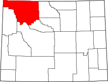 | |
| Towns | ||
| CDPs | ||
| Unincorporated communities | ||
| Ghost town | ||
| Footnotes | ‡This populated place also has portions in an adjacent county or counties | |
Cheyenne (capital) | |
| Topics |
|
| Society |
|
| Regions | |
| Cities | |
| Counties | |