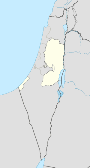
Rafat, Jerusalem
For the town in the Salfit Governorate, see Rafat, Salfit.
| Rafat | |
|---|---|
| Other transcription(s) | |
| • Arabic | رافات |
|
Rafat | |
 Rafat Location of Rafat within the Palestinian territories | |
| Coordinates: 31°52′14″N 35°11′32″E / 31.87056°N 35.19222°ECoordinates: 31°52′14″N 35°11′32″E / 31.87056°N 35.19222°E | |
| Governorate | Jerusalem |
| Government | |
| • Type | Village council |
| Area | |
| • Jurisdiction | 3,773 dunams (3.8 km2 or 1.5 sq mi) |
| Population (2006) | |
| • Jurisdiction | 2,100 |
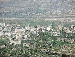
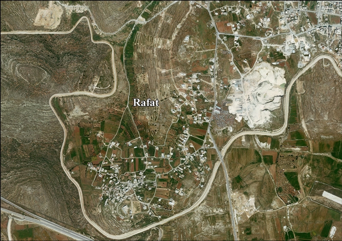
Rafat (Arabic: رافات) is a Palestinian town, located approximately 4 km (2.5 mi) southwest of the city of Ramallah in the central West Bank in the northern Jerusalem Governorate. According to a census conducted in 1931 by the British Mandate authorities, Rafat had a population of 218 inhabitants, in 46 houses.[1] According to the Palestinian Central Bureau of Statistics, it had a population of 2,100 in 2006.[2] Its total land area consists of 3,773 dunams.
Notable people
- Yahya Ayyash, Hamas bombing mastermind[3]
References
Bibliography
| Wikimedia Commons has media related to Rafat, Jerusalem. |
- Barron, J. B., ed. (1923). Palestine: Report and General Abstracts of the Census of 1922. Government of Palestine.
- Conder, Claude Reignier; Kitchener, H. H. (1883). The Survey of Western Palestine: Memoirs of the Topography, Orography, Hydrography, and Archaeology. 3. London: Committee of the Palestine Exploration Fund. (pp. 13, 154-155)
- Dauphin, Claudine (1998). La Palestine byzantine, Peuplement et Populations. BAR International Series 726 (in French). III : Catalogue. Oxford: Archeopress. ISBN 0-860549-05-4. (p. 843)
- Department of Statistics (1945). Village Statistics, April, 1945. Government of Palestine.
- Guérin, Victor (1868). Description Géographique Historique et Archéologique de la Palestine (in French). 1: Judee, pt. 1. Paris: L'Imprimerie Nationale. (pp. 392-393)
- Hadawi, Sami (1970). Village Statistics of 1945: A Classification of Land and Area ownership in Palestine. Palestine Liberation Organization Research Center. (pp. 58, 104, 154)
- Hütteroth, Wolf-Dieter; Abdulfattah, Kamal (1977). Historical Geography of Palestine, Transjordan and Southern Syria in the Late 16th Century. Erlanger Geographische Arbeiten, Sonderband 5. Erlangen, Germany: Vorstand der Fränkischen Geographischen Gesellschaft. ISBN 3-920405-41-2. (p. 118)
- Mills, E., ed. (1932). Census of Palestine 1931. Population of Villages, Towns and Administrative Areas (PDF). Jerusalem: Government of Palestine.
- Palmer, E. H. (1881). The Survey of Western Palestine: Arabic and English Name Lists Collected During the Survey by Lieutenants Conder and Kitchener, R. E. Transliterated and Explained by E.H. Palmer. Committee of the Palestine Exploration Fund. (p. 324)
- Robinson, Edward; Smith, Eli (1841). Biblical Researches in Palestine, Mount Sinai and Arabia Petraea: A Journal of Travels in the year 1838. 2. Boston: Crocker & Brewster. (pp. 133, 135)
- Socin, A. (1879). "Alphabetisches Verzeichniss von Ortschaften des Paschalik Jerusalem". Zeitschrift des Deutschen Palästina-Vereins. 2: 135–163. (p. 158)
External links
- Welcome To Rafat
- Survey of Western Palestine, Map 17: IAA, Wikimedia commons
- Rafat Village (Fact Sheet), ARIJ
- Rafat Village Profile, ARIJ
- Rafat, aerial photo, ARIJ

This article is issued from Wikipedia - version of the 11/29/2016. The text is available under the Creative Commons Attribution/Share Alike but additional terms may apply for the media files.