Ramsgate Beach, New South Wales
| Ramsgate Beach Sydney, New South Wales | |||||||||||||
|---|---|---|---|---|---|---|---|---|---|---|---|---|---|
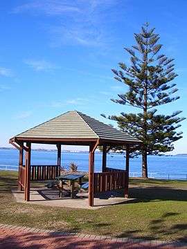 Cook Park, Ramsgate Beach | |||||||||||||
| Population | 1,422 (2006 census)[1] | ||||||||||||
| Postcode(s) | 2217 | ||||||||||||
| Location | 16 km (10 mi) south of Sydney CBD | ||||||||||||
| LGA(s) | Bayside Council | ||||||||||||
| State electorate(s) | Rockdale | ||||||||||||
| Federal Division(s) | Cook | ||||||||||||
| |||||||||||||
Ramsgate Beach is a suburb in southern Sydney, in the state of New South Wales, Australia. Ramsgate Beach is located 16 kilometres south of the Sydney central business district, in the Bayside Council and is part of the St George area. The postcode is 2217. Ramsgate is a separate suburb, to the west.
Ramsgate Beach is surrounded by the suburbs of Monterey, Ramsgate and Sans Souci. Lady Robinson Beach and Cook Park run along the eastern border of Ramsgate Beach, on Botany Bay. The suburb is mostly residential with a shopping strip including a supermarket on Ramsgate Road, near The Grand Parade. Another shopping strip, including the post office, is located in Ramsgate on Rocky Point Road, near the intersection of Ramsgate Road.
History
The area between the Cooks River and Georges River was originally known as Seven Mile Beach. It was changed to Lady Robinson’s Beach in 1874 to honour Governor Sir Hercules Robinson’s wife. Cook Park is named after Samuel Cook who advocated it as a public pleasure area. Ramsgate was named after the seaside resort in England. A model village was originally planned for the suburb but later abandoned.[2]
Population
According to the 2006 Australian Bureau of Statistics Census of Population, there were 1,422 people usually resident in Ramsgate Beach. 30.6% stated they were born overseas with the top countries of birth being United Kingdom 4.0%, New Zealand 3.0% and Greece 2.5%. English was stated as the only language spoken at home by 61.7% of residents and the most common other languages spoken were Greek 7.7%, Spanish 2.8% and Italian 2.2%. The most common responses for religious affiliation were Catholic 26.8%, Anglican, 21.1% and Orthodox 14.6%.[1]
Landmarks
- Lady Robinsons Beach
- Cook Park
- Ramsgate Beach Baths
- Ramsgate Baptist Church
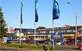 Ramsgate Beach Plaza, Ramsgate Road
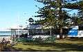 Restaurant, Cook Park
 Life Saving Club, Cook Park
 Ramsgate Beach Flower
References
- 1 2 http://info.id.com.au/dosydney/default.aspx?pg=1&gid=5080
- ↑ The Book of Sydney Suburbs, Compiled by Frances Pollon, Angus & Robertson Publishers, 1990, Published in Australia ISBN 0-207-14495-8, pages 216-217
| Wikimedia Commons has media related to Ramsgate Beach, New South Wales. |
Coordinates: 33°58′55″S 151°08′53″E / 33.982°S 151.148°E