Revere Beach (MBTA station)
REVERE BEACH | |||||||||||
|---|---|---|---|---|---|---|---|---|---|---|---|
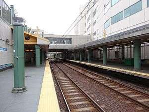 The platforms and bridge connecting them in 2016 | |||||||||||
| Location |
220 Shirley Avenue at 300 Ocean Avenue Revere, Massachusetts | ||||||||||
| Coordinates | 42°24′28″N 70°59′33″W / 42.4078°N 70.9926°WCoordinates: 42°24′28″N 70°59′33″W / 42.4078°N 70.9926°W | ||||||||||
| Line(s) | |||||||||||
| Platforms | 2 side platforms | ||||||||||
| Tracks | 2 | ||||||||||
| Connections |
| ||||||||||
| Construction | |||||||||||
| Bicycle facilities | 11 spaces | ||||||||||
| Disabled access | Yes | ||||||||||
| History | |||||||||||
| Opened | January 19, 1954[1] | ||||||||||
| Rebuilt | June 24, 1995[2][1] | ||||||||||
| Previous names | Crescent Beach (BRB&L) | ||||||||||
| Traffic | |||||||||||
| Passengers (2013) | 3,197 (daily boardings)[3] | ||||||||||
| Services | |||||||||||
| |||||||||||
Revere Beach is a rapid transit station on the MBTA Blue Line, located between Beach Street and Shirley Avenue in Revere, Massachusetts. It serves Revere Beach, a popular summer destination with a substantial year-round resident population. It opened in January 1954 on the site of a former Boston, Revere Beach and Lynn Railroad station, as part of an extension to Wonderland. Revere Beach station was closed and rebuilt from 1994 to 1995.
History
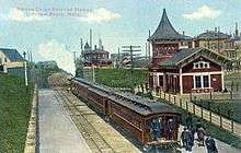
The narrow gauge Boston, Revere Beach and Lynn Railroad (BRB&L) opened from East Boston to Lynn on July 29, 1875. The line ran directly adjacent to the beachfront, a popular summer destination, on the alignment of the modern Revere Beach Boulevard. Revere station was located between Beach Street and Shirley Avenue.[4] The station was renamed Pavilion in the late 1870s and Crescent Beach in 1884.[5]
The Eastern Railroad-backed Boston, Winthrop, and Shore Railroad (BW&S) operated slightly inland in 1884 and 1885, with its own Crescent Beach station just west of the BRB&L station.[6][7] In April 1897, the BRB&L was moved inland onto the BW&S right-of-way, with Crescent Beach station relocated to the new alignment.[8] By 1928 the line was electrified, with pre-pay stations - more a rapid transit line than a conventional railroad.[9] However, due to the Great Depression, the BRB&L shut down on January 27, 1940.[6]
Rapid transit
In 1941, the Boston Elevated Railway bought the BRB&L right of way from Day Square to Revere Beach for use as a high-speed trolley line similar to the Ashmont-Mattapan High Speed Line; these plans were delayed by the onset of World War II.[8] The 1926 Report on Improved Transportation Facilities and 1945–47 Coolidge Commission Report recommended that the East Boston Tunnel line, which had been converted to rapid transit from streetcars in 1924, be extended to Lynn via the BBRB&L route rather than using it for a trolley line.[10][11]
In 1947, the newly formed Metropolitan Transit Authority (M.T.A.) decided to build to Lynn as a rapid transit line, and construction began in October 1948.[8] The first part of the Revere Extension opened to Orient Heights in January 1952 and Suffolk Downs in April 1952; the second phase (cut short due to limited funds) opened to Wonderland on January 19, 1954 with intermediate stations at Beachmont and Revere Beach.[8][10][1]
Renovations
Wonderland was closed for approximately one year starting on June 25, 1994 as the station was rebuilt along with Suffolk Downs, Beachmont, and Wonderland stations as part of the Blue Line Modernization Program. Blue Line service temporarily ended at Orient Heights and buses served the closed stations during the $467 million improvement project to upgrade four stations on the line.[12][1] Revere Beach station was largely rebuilt at a cost of $9.8 million; it reopened along with the other stations on June 24, 1995.[2]
The station was closed while additional platform repair work was performed from August 2 through 29, 2008.[1]
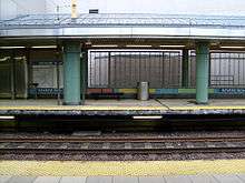
Platform layout
Like all Blue Line stations from Airport east, Revere Beach has two tracks and two side platforms. Uniquely among Blue Line stations, it is located below grade in a trench, with a surface-level fare lobby. Entrances to the station are from Beach Street and Shirley Avenue.
| Platform level | Side platform, doors will open on the right | |
| Southbound | ← Blue Line toward Bowdoin or Government Center (Beachmont) | |
| Northbound | → Blue Line toward Wonderland (Terminus) → | |
| Ground | - | Exit/Entrance |
Bus connections
Revere Beach station is served by three MBTA Bus routes:
- 110 Wonderland or Broadway & Park Ave - Wonderland or Broadway & Park Avenue - Wellington Station via Park Avenue & Woodlawn
- 117 Wonderland Station - Maverick Station via Beach Street
- 411 Malden Center Station - Revere/Jack Satter House via Granada Highlands and Northgate
The 411, operating on a one-way loop, stops one block east of the station on Ocean Avenue at Beach Street and one block west on Beach Street. Wonderland-bound 110 and 117 buses stop on Beach Street one block west of the station, while buses operating towards Wellington and Maverick stop further away. All three routes stop directly at Wonderland, one stop to the north on the Blue Line.[13]
References
- 1 2 3 4 5 Belcher, Jonathan (27 June 2015). "Changes to Transit Service in the MBTA district 1964-2015" (PDF). NETransit. Retrieved 24 December 2015.
- 1 2 Blake, Andrew (18 June 1995). "Blue Line Stations Set to Reopen After $467M Upgrade". Boston Globe. Retrieved 4 July 2015 – via Highbeam Research. (subscription required (help)).
- ↑ "Ridership and Service Statistics" (PDF) (14 ed.). Massachusetts Bay Transportation Authority. 2014. Retrieved 23 November 2015.
- ↑ Bradlee, Francis Boardman Crowninshield (1921). The Boston, Revere Beach and Lynn Narrow Gauge Railroad. Essex Institute. p. 4-5 – via Google Books.
- ↑ Stanley, Robert C. (1980). Narrow Gauge: The Story of the Boston, Revere Beach & Lynn Railroad. Boston Street Railway Association.
- 1 2 Karr, Ronald Dale (1995). The Rail Lines of Southern New England. Branch Line Press. pp. 268–272. ISBN 0942147022.
- ↑ "Part of the Town of Revere". Atlas of the City of Chelsea and the Towns of Revere and Winthrop. G.W. Bromley and Co. 1886 – via WardMaps.
- 1 2 3 4 Cheney, Frank (2003). Boston's Blue Line. Arcadia Publishing. p. 8, 74-75, 83. ISBN 9780738535760.
- ↑ ""Narrow Gage" Electrified for Economy". Electric Railway Journal. 72 (23): 991–998. 8 December 1928. Retrieved 24 December 2015 – via Internet Archive.
- 1 2 Central Transportation Planning Staff (15 November 1993). "The Transportation Plan for the Boston Region - Volume 2". National Transportation Library. Retrieved 3 July 2012.
- ↑ Boston Elevated Railway and Boston Department of Public Utilities (1945), Boston Rapid Transit System & Proposed Extentions 1945 - Metropolitan Transit Recess Commission Air View
- ↑ Blake, Andrew (20 March 1994). "MBTA to begin $467 million Blue Line project". Boston Globe. Retrieved 26 January 2014 – via Highbeam Research. (subscription required (help)).
- ↑ "Revere Beach Station Neighborhood Map" (PDF). Massachusetts Bay Transportation Authority. April 2012. Retrieved 23 November 2015.
External links
| Wikimedia Commons has media related to Revere Beach (MBTA station). |
- MBTA - Revere Beach
- Beach Street entrance from Google Maps Street View
- Shirley Avenue entrance from Google Maps Street View
| Subway lines (List of stations) |
| |||||||||||
|---|---|---|---|---|---|---|---|---|---|---|---|---|
| Commuter Rail lines (List of stations) |
| |||||||||||
| Bus routes (List of routes) | ||||||||||||
| Other services | ||||||||||||
| Component parts of system lines | ||||||||||||
| Capital projects |
| |||||||||||
| History |
| |||||||||||
| Other | ||||||||||||