Richland Junction, Washington
| Richland Junction, Washington | |
|---|---|
| neighborhood | |
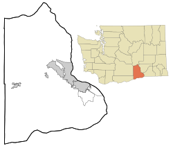 Richland Junction, Washington Location of Richland Junction, Washington | |
| Coordinates: 46°13′56″N 119°13′38″W / 46.2323571°N 119.2272378°WCoordinates: 46°13′56″N 119°13′38″W / 46.2323571°N 119.2272378°W[1] | |
| Country | United States |
| State | Washington |
| County | Benton |
| Elevation[2] | 394 ft (120 m) |
| Time zone | Pacific (PST) (UTC-8) |
| • Summer (DST) | PDT (UTC-7) |
| ZIP code | 99353 |
| Area code(s) | 509 |
| GNIS feature ID | 1511258[2] |
Richland Junction is a neighborhood of Richland in Benton County, Washington, United States. It is located within the east city limits of Richland.
Original known as Chemna, Richland Junction was founded in 1900 by Benjamin Rosencrance, a settler who purchased land from the Northern Pacific Railway Company for use as the Benton Post Office. The name was changed to Richland in honor of Nelson Rich in 1905. Rich, a state legislator from Prosser, and a partner in an irrigation company, helped secure the townsite.[3][4]
References
- ↑ "Richland Junction". Geographic Names Information System. United States Geological Survey. Retrieved 2012-10-28.
- 1 2 "US Board on Geographic Names". United States Geological Survey. 2007-10-25. Retrieved 2008-01-31.
- ↑ "Station Roster Master List: Richland Junction". Northern Pacific Railway Historical Association. Retrieved October 30, 2012.
- ↑ "Washington Place Names database". Tacoma Public Library. Retrieved October 30, 2012.
Municipalities and communities of Benton County, Washington, United States | ||
|---|---|---|
| Cities | 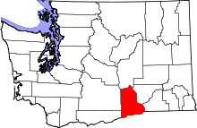 | |
| CDPs | ||
| Unincorporated communities | ||
| Unincorporated communities | ||
This article is issued from Wikipedia - version of the 9/3/2016. The text is available under the Creative Commons Attribution/Share Alike but additional terms may apply for the media files.