Rochester (CDP), Vermont
| Rochester, Vermont | |
|---|---|
| Census-designated place | |
_highlighted.svg.png) Location in Windsor County and the state of Vermont. | |
| Coordinates: 43°52′28″N 72°48′29″W / 43.87444°N 72.80806°WCoordinates: 43°52′28″N 72°48′29″W / 43.87444°N 72.80806°W | |
| Country | United States |
| State | Vermont |
| County | Windsor |
| Area | |
| • Total | 0.64 sq mi (1.67 km2) |
| • Land | 0.63 sq mi (1.64 km2) |
| • Water | 0.01 sq mi (0.03 km2) |
| Elevation | 870 ft (270 m) |
| Population (2010) | |
| • Total | 299 |
| • Density | 460/sq mi (180/km2) |
| Time zone | Eastern (EST) (UTC-5) |
| • Summer (DST) | EDT (UTC-4) |
| ZIP code | 05767 |
| Area code(s) | 802 |
| FIPS code | 50-60025[1] |
| GNIS feature ID | 1461345[2] |
Rochester is a census-designated place (CDP) that comprises the central village of the town of Rochester, Windsor County, Vermont, United States. As of the 2010 census, the population of the CDP was 299,[3] compared to 1,139 for the entire town of Rochester.
Geography
Rochester is located in extreme northwest Windsor County, along the White River. Vermont Route 100 passes through the village, heading north to Hancock, Granville, and Warren, and south to Stockbridge. Vermont Route 73 leads west from Rochester, crossing the Green Mountains to Brandon.
References
- ↑ "American FactFinder". United States Census Bureau. Retrieved 2008-01-31.
- ↑ "US Board on Geographic Names". United States Geological Survey. 2007-10-25. Retrieved 2008-01-31.
- ↑ "Profile of General Population and Housing Characteristics: 2010 Demographic Profile Data (DP-1): Rochester CDP, Vermont". U.S. Census Bureau, American Factfinder. Retrieved August 1, 2012.
Municipalities and communities of Windsor County, Vermont, United States | ||
|---|---|---|
| Towns | 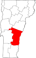 | |
| Villages | ||
| CDPs | ||
| Other communities | ||
This article is issued from Wikipedia - version of the 1/17/2016. The text is available under the Creative Commons Attribution/Share Alike but additional terms may apply for the media files.