Roll, Oklahoma
| Roll | |
|---|---|
| Unincorporated community | |
 Roll  Roll Location within the state of Oklahoma | |
| Coordinates: 35°46′45″N 99°42′41″W / 35.77917°N 99.71139°WCoordinates: 35°46′45″N 99°42′41″W / 35.77917°N 99.71139°W | |
| Country | United States |
| State | Oklahoma |
| County | Roger Mills |
| Time zone | Central (CST) (UTC-6) |
| • Summer (DST) | CDT (UTC-5) |
Roll is a small rural community located in Roger Mills County, Oklahoma on U.S. Highway 283 at the junction with State Highway 47. Founded in old Day County, the post office was opened December 9, 1903. It closed August 31, 1920.
Sources
- Shirk, George H. Oklahoma Place Names. Norman: University of Oklahoma Press, 1987. ISBN 0-8061-2028-2 .
Municipalities and communities of Roger Mills County, Oklahoma, United States | ||
|---|---|---|
| Towns | 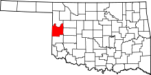 | |
| Unincorporated communities | ||
| Footnotes | ‡This populated place also has portions in an adjacent county or counties | |
This article is issued from Wikipedia - version of the 7/31/2016. The text is available under the Creative Commons Attribution/Share Alike but additional terms may apply for the media files.