Rovensko
See also: Rovensko (disambiguation)
| Rovensko | ||
| Village | ||
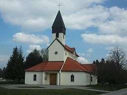 Local church in Rovensko, Slovakia | ||
|
||
| Country | Slovakia | |
|---|---|---|
| Region | Trnava | |
| District | Senica | |
| Traditional county | Nyitra | |
| Elevation | 216 m (709 ft) | |
| Coordinates | SK 48°43′00″N 17°23′00″E / 48.71667°N 17.38333°ECoordinates: SK 48°43′00″N 17°23′00″E / 48.71667°N 17.38333°E | |
| Area | 10.4 km2 (4 sq mi) | |
| Population | 393 (2007) | |
| Density | 38/km2 (98/sq mi) | |
| Settled | 1439 [1] | |
| Mayor | Ján Ňukovič (SDKÚ-DS) | |
| Timezone | CET (UTC+1) | |
| - summer (DST) | CEST (UTC+2) | |
| Postcode | 905 01 | |
| Area code | 034 | |
| Municipality code | 504777 | |
| Licence plate prefix | SE | |
| MGRS code | 33UXP7530398700 | |
| UTM/UPS | 33N 675303 5398700 | |
| Major airport | M. R. Štefánik Airport (Bratislava - BTS) | |
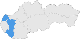 Location of Rovensko in the Trnava region (highlighted) of Slovakia. | ||
| Wikimedia Commons: Administrative units of Slovakia | ||
| Statistics: Rovensko, Infostat Bratislava | ||
| Website: www.rovensko.sk | ||
| www.e-obce.sk[2] | ||

Rovensko (Hungarian: Berencsróna, til 1899: Rovenszkó) is a village and municipality administered as part of Senica District in the Trnava Region of western Slovakia. The village is about 5 km NNE of the town of Senica and is close to the border with the Czech Republic.
History
In historical records the village was first mentioned in 1439.
Geography
The municipality lies at an altitude of 216 metres and covers an area of 1,040 hectares. In 2007 the population was 393.
Notes
External links
Municipalities of Senica District | ||
|---|---|---|
| Wikimedia Commons has media related to Rovensko. |
This article is issued from Wikipedia - version of the 11/16/2013. The text is available under the Creative Commons Attribution/Share Alike but additional terms may apply for the media files.