Štefanov
| Štefanov | |
| Village | |
 | |
| Country | Slovakia |
|---|---|
| Region | Trnava |
| District | Senica |
| Elevation | 205 m (673 ft) |
| Coordinates | SK 48°41′N 17°12′E / 48.683°N 17.200°ECoordinates: SK 48°41′N 17°12′E / 48.683°N 17.200°E |
| Area | 22.088 km2 (8.53 sq mi) |
| Population | 1,621 (2004-12-31) |
| Density | 73/km2 (189/sq mi) |
| First mentioned | 1392 |
| Postal code | 906 45 |
| Car plate | SE |
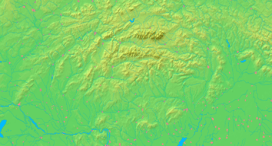  Location of Štefanov in Slovakia | |
  Location of Štefanov in the Trnava Region | |
| Statistics: MOŠ/MIS | |
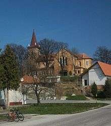
Church
Štefanov is a village and municipality in Senica District in the Trnava Region of western Slovakia.
History
In historical records the village was first mentioned in 1392. The church in the village is a Catholic Church built in 1937.[1]
Geography
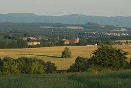
The municipality lies at an altitude of 205 metres and covers an area of 22.088 km². It has a population of about 1,621 people. It is located in the Záhorie region of Western Slovakia, on the edge between plains and hills.
References
- ↑ Cisarik, Juraj. "Genealogy - Tourist Guide - Slovakia - Kosice - Bratislava - Guide to Travel Trip Hotel Info Roots Forum Church Birth Records of Slovakia". www.cisarik.com. Retrieved 2016-10-03.
External links
Municipalities of Senica District | ||
|---|---|---|
This article is issued from Wikipedia - version of the 10/4/2016. The text is available under the Creative Commons Attribution/Share Alike but additional terms may apply for the media files.