Hlboké
| Hlboké | |
| Village | |
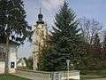 Lutheran church | |
| Country | Slovakia |
|---|---|
| Region | Trnava |
| District | Senica |
| Tourism region | Záhorie |
| Elevation | 247 m (810 ft) |
| Coordinates | SK 48°39′50″N 17°24′40″E / 48.66389°N 17.41111°ECoordinates: SK 48°39′50″N 17°24′40″E / 48.66389°N 17.41111°E |
| Area | 20.212 km2 (7.804 sq mi) |
| Population | 918 (31 December 2005) |
| Density | 45/km2 (117/sq mi) |
| First mentioned | 1262 |
| Timezone | CET (UTC+1) |
| - summer (DST) | CEST (UTC+2) |
| Postal code | 906 31 |
| Area code | +421-34 |
| Car plate | SE |
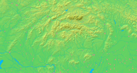  Location of Hlboké in Slovakia | |
  Location of Hlboké in the Trnava Region | |
| Statistics: MOŠ/MIS | |
| Website: www.hlboke.sk | |
Hlboké, (Hungarian: Luboka) is a village and municipality in Senica District in the Trnava Region of western Slovakia.
History
In historical records the village was first mentioned in 1262. In 1843 the Štúr's Slovak language was codified in the village.[1][2]
Geography
The municipality lies at an altitude of 247 metres and covers an area of 20.212 km². It has a population of about 905 people.[3] The village is at 48 ° 39'30 "S 17 ° 24'25" W.
Famous people
- Jozef Miloslav Hurban, Slovak politician
- Svetozár Hurban-Vajanský, Slovak writer
Genealogical resources
The records for genealogical research are available at the state archive "Statny Archiv in Bratislava, Slovakia"
- Roman Catholic church records (births/marriages/deaths): 1692-1895 (parish B)
- Lutheran church records (births/marriages/deaths): 1733-1896 (parish A)
Gallery
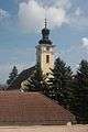 1787 Lutheran Church Building
- Hlboke se
See also
References
External links
Municipalities of Senica District | ||
|---|---|---|
This article is issued from Wikipedia - version of the 2/4/2016. The text is available under the Creative Commons Attribution/Share Alike but additional terms may apply for the media files.