Runanga, New Zealand
| Runanga | |
|---|---|
 Runanga | |
| Coordinates: 42°24′2″S 171°15′5″E / 42.40056°S 171.25139°ECoordinates: 42°24′2″S 171°15′5″E / 42.40056°S 171.25139°E | |
| Country | New Zealand |
| Region | West Coast |
| District | Grey District |
| Population (2006) | |
| • Total | 1,221 |
Runanga is a small town on the West Coast of the South Island of New Zealand. It is located eight kilometres to the northeast of Greymouth, to the north of the Grey River. Barrytown is 21 kilometres (13 mi) further north. State Highway 6 and the Rapahoe Branch railway run through the town.[1][2] Runanga was formerly a railway junction, with the steep Rewanui Branch diverging from the Rapahoe line until closure in 1985.
The population of Runanga and its surrounds, including the separate settlement of Rapahoe to the north-west, was 1,221 in the 2006 Census, a decrease of 84 from 2001.[3]
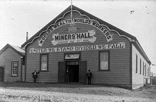
The town's origins can be traced back to European colonisation in the late 19th century, when large numbers of settlers came to work the local coal fields. The town's name is Maori for "meeting place".[4] Coal mining is still the main employer of the town.
History
During the period, 1853 to 1876, Runanga was administrated as part of the Nelson Province.
Community
As with most other towns, Runanga had its fair share of clubs and societies. One such organisation that no longer exists in Runanga, and which few may remember, is the Runanga Lodge No 74 of the Royal Antedilluvian Order of Buffaloe's. This Lodge was opened on May 13, 1939, by the Provincial Grand Primo Bro. James Insull K.O.M. The founders of the lodge were Bro. C Ingram C.P. and Bro. T Durkin C.P.
The Foundation members were R McMillan, H Fisher, J Musgrove, J O'Connel, W.T. Foster, F Crange, R McTaggart, Owen O'Connell, G.W. Timlin, A.W. Fisher, W Amor, J Stephens, D Butler, S H Werner, J O'Neil and R Scott.
In April 1943, The Lodge held their first meeting in their own Hall. They had been meeting in rented accommodation up until then.
Notable people
- George Henry Duggan (3 July 1912 – 16 December 2012)[1] was a New Zealand Marist priest, philosopher, seminary professor and writer (he was popularly known as Chalky Duggan - after a featherweight boxer who fought in 1919, when Duggan was 7 years old, under the name "Chalky Duggan" and who, like Duggan, came from Runanga.
- James O'Brien, Labour MP for Westland 1922-25 and 1928–1947 and Minister of Transport and Marine during the First Labour Government, lived and worked in Runanga from 1906 for about ten years.[5]
- Bob Semple, Minister of Public Works in the First Labour Government, was President of the Runanga Miner's Union in 1907.[6]
- Paddy Webb, Minister of Mines in the First Labour Government, worked in the Runanga mine about 1906.[7]
- George Menzies, who in 2008 was named the greatest rugby league five-eighth New Zealand had ever produced spent his playing career at Runanga's club.
Education
Runanga School is a coeducational full primary school (years 1-8), with a decile rating of 3 and a roll of 103.[8]
Notes
- ↑ Peter Dowling (editor) (2004). Reed New Zealand Atlas. Reed Books. map 69. ISBN 0-7900-0952-8.
- ↑ Roger Smith, GeographX (2005). The Geographic Atlas of New Zealand. Robbie Burton. map 148. ISBN 1-877333-20-4.
- ↑ Quickstats about Runanga-Rapahoe
- ↑ "Runanga". Encyclopedia of New Zealand (1966).
- ↑ "O'Brien, James". Dictionary of New Zealand Biography.
- ↑ "SEMPLE, Hon. Robert". Encyclopedia of New Zealand (1966).
- ↑ "Webb, Patrick Charles". Dictionary of New Zealand Biography.
- ↑ "Te Kete Ipurangi - Runanga School". Ministry of Education.