Rushville, Indiana
| City of Rushville | |
|---|---|
| City | |
|
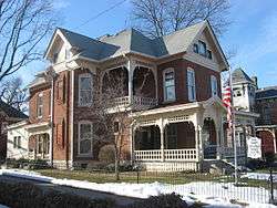
The John K. Gowdy House in Rushville | |
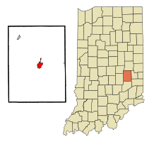 Location in the state of Indiana | |
| Coordinates: 39°36′52″N 85°26′55″W / 39.61444°N 85.44861°WCoordinates: 39°36′52″N 85°26′55″W / 39.61444°N 85.44861°W | |
| Country | United States |
| State | Indiana |
| County | Rush |
| Township | Rushville |
| Government | |
| • Mayor R | Mike Pavey (R) |
| Area | |
| • Total | 3.09 sq mi (8.0 km2) |
| • Land | 3.09 sq mi (8.0 km2) |
| • Water | 0.00 sq mi (0.0 km2) 0% |
| Elevation | 958 ft (292 m) |
| Population (2010) | |
| • Total | 6,341 |
| • Density | 2,668.8/sq mi (1,028.7/km2) |
| Time zone | EST (UTC-5) |
| • Summer (DST) | EDT (UTC-4) |
| ZIP code | 46173 |
| Area code(s) | 765 |
| FIPS code | 18-66438[1] |
| GNIS feature ID | 0442410[2] |
| Website | http://www.cityofrushville.in.gov/ |
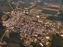
Rushville is a city in Rushville Township, Rush County, Indiana, United States. The population was 6,341 at the 2010 census. The city is the county seat of Rush County.[3] It was the campaign headquarters for Wendell Willkie's 1940 presidential campaign against Franklin D. Roosevelt. Willkie is buried in the city's East Hill Cemetery. It, like the county, was named in honor of Dr. Benjamin Rush, who signed the Declaration of Independence.[4]
History
Rush County was formed from the unorganized Delaware County April 1, 1822. On July 29 town lots were sold and the town started to form. A school had already been started in 1821 by Dr. W.B. Laughlin, who was a member of the Legislature when the county was formed, and is considered the founding father of the town. A jail was built, Charles Veeder, was the first postmaster in 1822, and a courthouse was built in 1823. The Dog Fennel Gazette was published in 1823. The railroad was built in 1850 and after that a bank, factories, mills, and grain elevators sprang up.[5]
The Durbin Hotel, John K. Gowdy House, Melodeon Hall, Rush County Courthouse, Rushville Commercial Historic District, St. Paul Methodist Episcopal Church, Booker T. Washington School, and Wendell Lewis Willkie House are listed on the National Register of Historic Places.[6]
Geography
Rushville is located at 39°36′52″N 85°26′55″W / 39.61444°N 85.44861°W (39.614482, -85.448657),[7] along the Flatrock River.[8]
According to the 2010 census, Rushville has a total area of 3.09 square miles (8.00 km2), all land.[9]
Demographics
| Historical population | |||
|---|---|---|---|
| Census | Pop. | %± | |
| 1850 | 742 | — | |
| 1860 | 972 | 31.0% | |
| 1870 | 1,696 | 74.5% | |
| 1880 | 2,515 | 48.3% | |
| 1890 | 3,475 | 38.2% | |
| 1900 | 4,541 | 30.7% | |
| 1910 | 4,925 | 8.5% | |
| 1920 | 5,498 | 11.6% | |
| 1930 | 5,709 | 3.8% | |
| 1940 | 5,960 | 4.4% | |
| 1950 | 6,761 | 13.4% | |
| 1960 | 7,264 | 7.4% | |
| 1970 | 6,686 | −8.0% | |
| 1980 | 6,113 | −8.6% | |
| 1990 | 5,533 | −9.5% | |
| 2000 | 5,995 | 8.3% | |
| 2010 | 6,341 | 5.8% | |
| Est. 2015 | 6,077 | [10] | −4.2% |
As of the census[1] of 2000, there were 5,995 people, 2,434 households, and 1,552 families residing in the city. The population density was 2,668.8 people per square mile (1,028.7/km²). There were 2,597 housing units at an average density of 1,156.1 per square mile (445.6/km²). The racial makeup of the city was 96.45% White, 1.58% African American, 0.20% Native American, 0.85% Asian, 0.05% Pacific Islander, 0.13% from other races, and 0.73% from two or more races. Hispanic or Latino of any race were 0.40% of the population.
There were 2,434 households out of which 31.2% had children under the age of 18 living with them, 46.9% were married couples living together, 12.7% had a female householder with no husband present, and 36.2% were non-families. 31.6% of all households were made up of individuals and 15.2% had someone living alone who was 65 years of age or older. The average household size was 2.39 and the average family size was 2.99.
In the city the population was spread out with 25.2% under the age of 18, 8.6% from 18 to 24, 28.6% from 25 to 44, 20.2% from 45 to 64, and 17.5% who were 65 years of age or older. The median age was 37 years. For every 100 females there were 89.0 males. For every 100 females age 18 and over, there were 85.0 males.
The median income for a household in the city was $30,233, and the median income for a family was $36,646. Males had a median income of $30,127 versus $22,440 for females. The per capita income for the city was $17,072. About 8.1% of families and 11.0% of the population were below the poverty line, including 12.3% of those under age 18 and 12.0% of those age 65 or over.
Notable people
- Samuel Bigger, Governor of Indiana
- Carmelita Geraghty, silent film actress
- Janet Gray Hayes, Mayor of San Jose, California
- Joe Hogsett, Indiana politician and lawyer
- Leonidas Sexton, 19th Century politician, was from Rushville.
- Knowles Shaw, author and composer
- Tony Stewart, NASCAR driver
- Frazier Thomas, television personality
- Wendell Willkie, United States Presidential candidate, lawyer, businessman
- Philip Willkie, Indiana politician and businessman
References
- 1 2 "American FactFinder". United States Census Bureau. Retrieved 2008-01-31.
- ↑ "US Board on Geographic Names". United States Geological Survey. 2007-10-25. Retrieved 2008-01-31.
- ↑ "Find a County". National Association of Counties. Retrieved 2011-06-07.
- ↑ De Witt Clinton Goodrich & Charles Richard Tuttle (1875). An Illustrated History of the State of Indiana. Indiana: R. S. Peale & co. p. 572.
- ↑ "The History of Rush County, Indiana". Volume II, Chapter VIII. Rush County INGENWEB. 1996. Retrieved October 11, 2015.
- ↑ National Park Service (2010-07-09). "National Register Information System". National Register of Historic Places. National Park Service.
- ↑ "US Gazetteer files: 2010, 2000, and 1990". United States Census Bureau. 2011-02-12. Retrieved 2011-04-23.
- ↑ DeLorme (1998). Indiana Atlas & Gazetteer. Yarmouth, Maine: DeLorme. ISBN 0-89933-211-0
- ↑ "G001 - Geographic Identifiers - 2010 Census Summary File 1". United States Census Bureau. Retrieved 2015-07-29.
- ↑ "Annual Estimates of the Resident Population for Incorporated Places: April 1, 2010 to July 1, 2015". Retrieved July 2, 2016.
- ↑ "Census of Population and Housing". Census.gov. Retrieved June 4, 2015.
External links
- City of Rushville website
- "Wendell Willkie, Presidential Contender" from C-SPAN's The Contenders, broadcast from Rushville
Municipalities and communities of Rush County, Indiana, United States | ||
|---|---|---|
| City | ||
| Towns | ||
| Townships | ||
| CDPs | ||
| Other unincorporated communities | ||
| Footnotes | ‡This populated place also has portions in an adjacent county or counties | |