Saddleback Mountain (Keene, New York)
| Saddleback Mountain | |
|---|---|
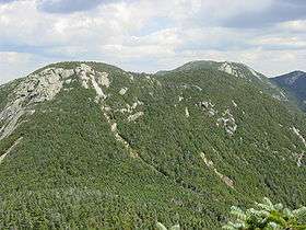 Saddleback Mountain as seen from the southwest during the ascent of Basin | |
| Highest point | |
| Elevation | 1,380 metres (4,528 ft) |
| Prominence | 115 m (380 ft)[1] |
| Listing | Adirondack High Peaks |
| Coordinates | 44°7.60′N 73°52.51′W / 44.12667°N 73.87517°WCoordinates: 44°7.60′N 73°52.51′W / 44.12667°N 73.87517°W |
| Geography | |
| Location | Keene, Essex County, New York |
| Parent range | the Great Range |
| Topo map | USGS Keene Valley / Mount Marcy |
Saddleback Mountain is a mountain located in Essex County, New York. The mountain is part of the Great Range of the Adirondack Mountains. The 0.2 mi (0.32 km) long summit ridge has peaks at each end with a pronounced dip between, giving it the profile of a saddle. Saddleback Mtn. is flanked to the southwest by Basin Mountain, and to the east by Gothics.
Saddleback Mountain stands within the watershed of the East Branch of the Ausable River, which drains into Lake Champlain, thence into Canada's Richelieu River, the Saint Lawrence River, and into the Gulf of Saint Lawrence. The southeast end and southwest side of Saddleback Mtn. drain into Shanty Brook, thence into the East Branch of the Ausable River between Upper and Lower Ausable Lake. The northwest end of Saddleback Mtn. drains into Chicken Coop Brook, thence into Johns Brook and the East Branch. The northeast side of Saddleback Mtn. drains into Ore Bed Brook, thence into Johns Brook.
Saddleback Mountain is within the High Peaks Wilderness Area of Adirondack State Park.

See also
- List of mountains in New York
- Northeast 111 4,000-footers
- Adirondack High Peaks
- Adirondack Forty-Sixers
Notes
External links
- Peakbagger.com: Saddleback Mountain
- Summitpost.org: Saddleback Mountain
- U.S. Geological Survey Geographic Names Information System: Saddleback Mountain