Seymour Mountain (Franklin County, New York)
| Seymour Mountain | |
|---|---|
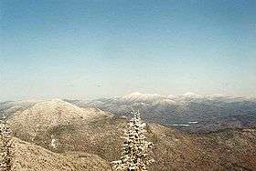 Seymour Mt. (L) seen from Donaldson Mt. | |
| Highest point | |
| Elevation | 1,247 metres (4,091 ft) |
| Prominence | 310 m (1,020 ft)[1] |
| Listing | Adirondack High Peaks |
| Coordinates | 44°9.49′N 74°10.36′W / 44.15817°N 74.17267°WCoordinates: 44°9.49′N 74°10.36′W / 44.15817°N 74.17267°W |
| Geography | |
| Location | Franklin County, New York |
| Parent range | Seward Mountains |
| Topo map | USGS Ampersand Lake |
Seymour Mountain is a mountain located in Franklin County, New York, named after Horatio Seymour (1810–1886), Governor of New York (1853–1854, 1863–1864). The mountain is part of the Seward Mountains of the Adirondacks. Seymour Mountain faces Seward Mountain to the west across Ouluska Pass.
Seymour Mountain stands within the watershed of the Raquette River, which drains into the Saint Lawrence River in Canada, and into the Gulf of Saint Lawrence. The east and southeast slopes of Seymour Mtn. drain via various brooks into the Cold River, a tributary of the Raquette River. The west side of Seymour Mtn. drains into Seward Brook, thence into the Cold River. The northern slopes of Seymour drain into Ward Brook, thence into Ampersand Lake, Ampersand Brook, Stony Creek, and the Raquette River.
Seymour Mountain is within the High Peaks Wilderness Area of New York's Adirondack Park.
Notes
See also
- List of mountains in New York
- Northeast 111 4,000-footers
- Adirondack High Peaks
- Adirondack Forty-Sixers
External links
- 46Mountains.com: Seymour Mountain
- Peakbagger.com: Seymour Mountain
- Summitpost.org: Seymour Mountain
- U.S. Geological Survey Geographic Names Information System: Seymour Mountain