Saint-Émile-de-Suffolk, Quebec
| Saint-Émile-de-Suffolk | |
|---|---|
| Municipality | |
 | |
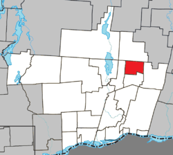 Location within Papineau RCM. | |
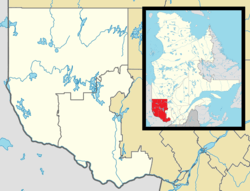 Saint-Émile-de-Suffolk Location in western Quebec. | |
| Coordinates: 45°56′N 74°55′W / 45.933°N 74.917°WCoordinates: 45°56′N 74°55′W / 45.933°N 74.917°W[1] | |
| Country |
|
| Province |
|
| Region | Outaouais |
| RCM | Papineau |
| Settled | 1860s |
| Constituted | January 1, 1881 |
| Government[2] | |
| • Mayor | Michel Samson |
| • Federal riding | Argenteuil—Papineau—Mirabel |
| • Prov. riding | Papineau |
| Area[2][3] | |
| • Total | 59.20 km2 (22.86 sq mi) |
| • Land | 58.40 km2 (22.55 sq mi) |
| Population (2011)[3] | |
| • Total | 566 |
| • Density | 9.7/km2 (25/sq mi) |
| • Pop 2006-2011 |
|
| • Dwellings | 410 |
| Time zone | EST (UTC−5) |
| • Summer (DST) | EDT (UTC−4) |
| Postal code(s) | J0T 1K0, J0V 1Y0 |
| Area code(s) | 819 |
| Highways |
|
| Website |
www de-suffolk |
Saint-Émile-de-Suffolk is a municipality in the Outaouais region of Quebec, Canada, part of the Papineau Regional County Municipality. Until 1994 it was known as United Township Municipality of Suffolk-et-Addington.
This farming community, 40 kilometers (25 mi) north of Montebello, is often visited by cottage vacationers for hunting and fishing in the numerous lakes of the area.[1]
Geography
The area is characterized by rugged terrain of the Laurentian Mountains, marked here and there by mountains that rise more than 400 meters (1,300 ft) above sea level.[4] Its principal streams are the Little Rouge River and the Suffolk Creek that feeds it, the first being a tributary of the Petite-Nation River.[5]
History
Suffolk Township (named after the county in England) was already on the Gale and Duberger map of 1795, but not officially established until 1874.[5] Municipally it was part of the United Township Municipality of Hartwell-et-Suffolk until 1880 when the municipality separated[6] and the Township Municipality of Suffolk was formed, taking effect on January 1, 1881.
In 1885, Addington Township (named after Henry Addington, 1st Viscount Sidmouth) [4] was merged with Suffolk Township, creating the United Township Municipality of Suffolk-et-Addington.[1]
In 1889, the Parish of Saint-Émile-de-Suffolk was formed. This name paid tribute to Émile Quesnel of Saint-Andre-Avellin, who had been particularly generous toward the early settlers of the area.[1]
Piece by piece, portions of the united township were detached to form new municipalities: Vinoy in 1920 (which became part of Chénéville in 1996), Lac-des-Plages in 1950, and finally Namur in 1964.[7]
In 1994, the name and status were changed to that of Municipality of Saint-Émile-de-Suffolk.[1]
Demographics
Population trend:[8]
- Population in 2011: 566 (2006 to 2011 population change: 5.4%)
- Population in 2006: 537
- Population in 2001: 528
- Population in 1996: 433
- Population in 1991: 448
Private dwellings occupied by usual residents: 247 (total dwellings: 410)
Mother tongue:
- English as first language: 11%
- French as first language: 89%
- English and French as first language: 0%
- Other as first language: 0%
References
- 1 2 3 4 5 "Saint-Émile-de-Suffolk (Municipalité)" (in French). Commission de toponymie du Québec. Retrieved 2010-04-27.
- 1 2 Ministère des Affaires municipales, des Régions et de l'Occupation du territoire - Répertoire des municipalités: Saint-Émile-de-Suffolk
- 1 2 Statistics Canada 2011 Census - Saint-Émile-de-Suffolk census profile
- 1 2 "Addington (Canton)" (in French). Commission de toponymie du Québec. Retrieved 2009-01-13.
- 1 2 "Suffolk (Canton)" (in French). Commission de toponymie du Québec. Retrieved 2009-01-13.
- ↑ "Lac-Simon (Municipalité)" (in French). Commission de toponymie du Québec. Retrieved 2008-12-02.
- ↑ "Namur (Municipalité)" (in French). Commission de toponymie du Québec. Retrieved 2009-01-12.
- ↑ Statistics Canada: 1996, 2001, 2006, 2011 census
 |
Lac-des-Plages | | ||
| Chénéville | |
Boileau | ||
| ||||
| | ||||
| Namur |
| Cities | |
|---|---|
| Municipalities | |
| Townships | |
| |