San Nicolas, Pangasinan
| San Nicolas | ||
|---|---|---|
| Municipality | ||
|
San Nicolas Town Hall | ||
| ||
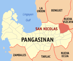 Map of Pangasinan showing the location of San Nicolas | ||
.svg.png) San Nicolas Location within the Philippines | ||
| Coordinates: 16°04′12″N 120°45′55″E / 16.07000°N 120.76528°ECoordinates: 16°04′12″N 120°45′55″E / 16.07000°N 120.76528°E | ||
| Country |
| |
| Region | Ilocos (Region I) | |
| Province | Pangasinan | |
| District | 6th district of Pangasinan | |
| Founded | 1610 | |
| Barangays | 33 | |
| Government[1] | ||
| • Mayor | Rebecca Mejica Saldivar | |
| Area[2] | ||
| • Total | 210.20 km2 (81.16 sq mi) | |
| Population (2010)[3] | ||
| • Total | 34,108 | |
| • Density | 160/km2 (420/sq mi) | |
| Time zone | PST (UTC+8) | |
| ZIP code | 2447 | |
| Dialing code | 75 | |
| Income class | 1st class; rural | |
| Website | www.sannicolas-lgu.com | |


San Nicolas is a first-class municipality in the province of Pangasinan, Philippines.
Barangays
San Nicolas is located in north-eastern part of Pangasinan and is politically subdivided into 33 barangays.[2]
- Bensican
- Cabitnongan
- Caboloan
- Cacabugaoan
- Calanutian
- Calaocan
- Camanggaan
- Camindoroan
- Casaratan
- Dalumpinas
- Fianza
- Lungao
- Malico
- Malilion
- Nagkaysa
- Nining
- Poblacion East
- Poblacion West
- Salingcob
- Salpad
- San Felipe East
- San Felipe West
- San Isidro (Sta. Cruzan)
- San Jose
- San Rafael Centro
- San Rafael East
- San Rafael West
- San Roque
- Santa Maria East
- Santa Maria West
- Santo Tomas
- Siblot
- Sobol
Places of interest
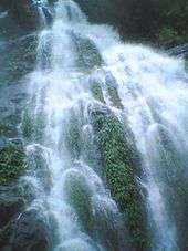
San Nicolas is a place with many waterfalls from the Caraballo Mountain Range and a number of rivers that serve as a picnic ground for vacationers during holidays and summertime.
Lipit falls are located in Barangay Sta. Maria East. It is an hour trail from the Red Arrow Monument along Cabalitian River. Best time to visit the place is during the summertime but it is also safe to go their during rainy seasons.
Agpay falls is in Barangay San Felipe East. During the '70s up to the '80s it is actually one of the best natural tourist spots in eastern Pangasinan.
Other waterfalls of interest include: Pinsal falls 1, 2 and 3, located in Sitio Nagsimbaoaan in Barangay Cacabugaoan; Mambolo falls, located at Brgy. Salpad and Pinsal Bensican in brgy. Bensican; and Baracbac falls are located in Barangay Fianza just north of Sitio Puyao.
Mejias Resort is located at town proper of San Nicolas. It has a wide space for picnic area and reception hall for kinds of parties and events.They are accepting decorating services and catering for all kinds of special events, including the concept and design, planning, day of coordination, and much more. They have also swimming pools for adults and children.
Krystala de Corazon is located at Barangay Calaocan, San Nicolas.
Esperanza's Garden is located at Barangay Cabitnongan, San Nicolas.
Cabalisian River - crystal clear water located at Brgy. Sta. Maria.
Demographics
According to the 2007 census, San Nicolas had a population of 33,419 people in 6,533 households. Its population increased to 34,108 in the 2010 census.[3]
| Population Census of San Nicolas | ||
|---|---|---|
| Year | Pop. | ±% p.a. |
| 1990 | 27,415 | — |
| 1995 | 29,058 | +1.10% |
| 2000 | 31,418 | +1.69% |
| 2007 | 33,419 | +0.86% |
| 2010 | 34,108 | +0.75% |
| 2015 | 35,574 | +0.80% |
| Source: National Statistics Office[3][4] | ||
Climate
| Climate data for San Nicolas, Pangasinan | |||||||||||||
|---|---|---|---|---|---|---|---|---|---|---|---|---|---|
| Month | Jan | Feb | Mar | Apr | May | Jun | Jul | Aug | Sep | Oct | Nov | Dec | Year |
| Average high °C (°F) | 31 (88) |
31 (88) |
32 (90) |
34 (93) |
35 (95) |
34 (93) |
32 (90) |
32 (90) |
32 (90) |
32 (90) |
32 (90) |
31 (88) |
32.3 (90.4) |
| Average low °C (°F) | 22 (72) |
22 (72) |
22 (72) |
24 (75) |
24 (75) |
24 (75) |
23 (73) |
23 (73) |
24 (75) |
23 (73) |
23 (73) |
22 (72) |
23 (73.3) |
| Average precipitation mm (inches) | 13.6 (0.535) |
10.4 (0.409) |
18.2 (0.717) |
15.7 (0.618) |
178.4 (7.024) |
227.9 (8.972) |
368 (14.49) |
306.6 (12.071) |
310.6 (12.228) |
215.7 (8.492) |
70.3 (2.768) |
31.1 (1.224) |
1,766.5 (69.548) |
| Average rainy days | 3 | 2 | 2 | 4 | 14 | 16 | 23 | 21 | 24 | 15 | 10 | 6 | 140 |
| Source: World Weather Online[5] | |||||||||||||
References
- ↑ "Official City/Municipal 2013 Election Results". Intramuros, Manila, Philippines: Commission on Elections (COMELEC). 1 July 2013. Retrieved 7 September 2013.
- 1 2 "Province: PANGASINAN". PSGC Interactive. Makati City, Philippines: National Statistical Coordination Board. Retrieved 26 November 2012.
- 1 2 3 "Total Population by Province, City, Municipality and Barangay: as of May 1, 2010" (PDF). 2010 Census of Population and Housing. National Statistics Office. Retrieved 26 November 2012.
- ↑ "Province of Pangasinan". Municipality Population Data. LWUA Research Division. Retrieved 5 September 2013.
- ↑ "San Nicolas, Pangasinan: Average Temperatures and Rainfall". World Weather Online. Retrieved 31 October 2015.
External links
| Wikimedia Commons has media related to San Nicolas, Pangasinan. |
- MySannicolas : Ang Tambayan ng Sannicolanians
- Philippine Standard Geographic Code
- Philippine Census Information
- Local Governance Performance Management System
 |
Itogon, Benguet | | ||
| San Manuel | |
Santa Fe, Nueva Vizcaya | ||
| ||||
| | ||||
| Tayug / Natividad | Carranglan, Nueva Ecija |
Lingayen (capital) | |
| Municipalities |
|
| Component cities | |
| Independent component city |
|
| Barangays | |