Sherrill, Iowa
| Sherrill, Iowa | |
|---|---|
| City | |
|
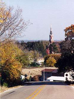
Sherrill seen from the mound | |
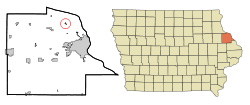 Location of Sherrill, Iowa | |
| Coordinates: 42°36′10″N 90°46′56″W / 42.60278°N 90.78222°WCoordinates: 42°36′10″N 90°46′56″W / 42.60278°N 90.78222°W | |
| Country |
|
| State |
|
| County | Dubuque |
| Area[1] | |
| • Total | 0.13 sq mi (0.34 km2) |
| • Land | 0.13 sq mi (0.34 km2) |
| • Water | 0 sq mi (0 km2) |
| Elevation | 981 ft (299 m) |
| Population (2010)[2] | |
| • Total | 177 |
| • Estimate (2012[3]) | 178 |
| • Density | 1,361.5/sq mi (525.7/km2) |
| Time zone | Central (CST) (UTC-6) |
| • Summer (DST) | CDT (UTC-5) |
| ZIP code | 52073 |
| Area code(s) | 563 |
| FIPS code | 19-72660 |
| GNIS feature ID | 0461574 |
Sherrill is a city in Dubuque County, Iowa, United States. The population was 177 at the 2010 census, down from 186 at the 2000 census.
History
Sherrill was named for two brothers, Adam and Isaac Sherrill, and was originally called Sherrill's Mound or Mount, since the city is sited at the base of a prominent hill. In 1856, Peter Fries, an Austrian immigrant, built a large, stone inn at the main crossroads of the city. It was popular with newlyweds, and Jesse James and his gang were reported to have stayed there prior to their famous raid on Northfield, Minnesota. The structure has survived and has been restored as the Black Horse Inn. Sherrill and the surrounding rural district received large numbers of German immigrants in the 19th century. German Catholic (SS. Peter and Paul), German Lutheran (St. Matthew), German Methodist, and German Evangelical churches were founded and remain active. Sherrill was one of ten "Beer Towns" incorporated in Dubuque County in 1933, to ensure that the city's taverns could serve beer, under a possibly mistaken interpretation of Iowa law that licenses to dispense beer could only be granted to premises inside incorporated places. Sherrill's post office was established in 1858, with Peter Fries as postmaster. Its Zip Code is 52073.
Geography
Sherrill is located at 42°36′10″N 90°46′56″W / 42.60278°N 90.78222°W (42.602857, -90.782139).[4]
According to the United States Census Bureau, the city has a total area of 0.13 square miles (0.34 km2), all of it land.[1]
Demographics
| Historical populations | ||
|---|---|---|
| Year | Pop. | ±% |
| 1940 | 82 | — |
| 1950 | 162 | +97.6% |
| 1960 | 174 | +7.4% |
| 1970 | 190 | +9.2% |
| 1980 | 208 | +9.5% |
| 1990 | 148 | −28.8% |
| 2000 | 186 | +25.7% |
| 2010 | 177 | −4.8% |
| 2014 | 176 | −0.6% |
| 2015 | 176 | +0.0% |
| Source:"American FactFinder". United States Census Bureau. and Iowa Data Center Source: | ||
2010 census
As of the census[2] of 2010, there were 177 people, 73 households, and 54 families residing in the city. The population density was 1,361.5 inhabitants per square mile (525.7/km2). There were 74 housing units at an average density of 569.2 per square mile (219.8/km2). The racial makeup of the city was 94.9% White, 2.3% African American, and 2.8% from other races. Hispanic or Latino of any race were 2.8% of the population.
There were 73 households of which 31.5% had children under the age of 18 living with them, 63.0% were married couples living together, 6.8% had a female householder with no husband present, 4.1% had a male householder with no wife present, and 26.0% were non-families. 24.7% of all households were made up of individuals and 15.1% had someone living alone who was 65 years of age or older. The average household size was 2.42 and the average family size was 2.89.
The median age in the city was 42.5 years. 23.7% of residents were under the age of 18; 9.1% were between the ages of 18 and 24; 19.8% were from 25 to 44; 24.2% were from 45 to 64; and 23.2% were 65 years of age or older. The gender makeup of the city was 52.5% male and 47.5% female.
2000 census
As of the census[6] of 2000, there were 186 people, 70 households, and 52 families residing in the city. The population density was 1,753.9 people per square mile (652.9/km²). There were 77 housing units at an average density of 726.1 per square mile (270.3/km²). The racial makeup of the city was 100.00% White. Hispanic or Latino of any race were 2.15% of the population.
There were 70 households out of which 31.4% had children under the age of 18 living with them, 68.6% were married couples living together, 5.7% had a female householder with no husband present, and 24.3% were non-families. 20.0% of all households were made up of individuals and 12.9% had someone living alone who was 65 years of age or older. The average household size was 2.66 and the average family size was 3.13.
In the city the population was spread out with 27.4% under the age of 18, 4.8% from 18 to 24, 26.3% from 25 to 44, 22.6% from 45 to 64, and 18.8% who were 65 years of age or older. The median age was 40 years. For every 100 females there were 104.4 males. For every 100 females age 18 and over, there were 101.5 males.
The median income for a household in the city was $38,125, and the median income for a family was $44,688. Males had a median income of $31,250 versus $20,000 for females. The per capita income for the city was $21,118. None of the families and 3.3% of the population were living below the poverty line.
Gallery
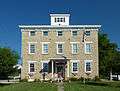 Black Horse Inn, originally the Sherrill Mount House
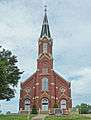 SS. Peter and Paul Catholic Church
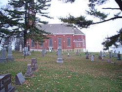 SS. Peter and Paul viewed from the cemetery
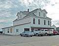 The Barn Bar
References
- 1 2 "US Gazetteer files 2010". United States Census Bureau. Retrieved 2012-05-11.
- 1 2 "American FactFinder". United States Census Bureau. Retrieved 2012-05-11.
- ↑ "Population Estimates". United States Census Bureau. Retrieved 2013-05-23.
- ↑ "US Gazetteer files: 2010, 2000, and 1990". United States Census Bureau. 2011-02-12. Retrieved 2011-04-23.
- ↑ "Census of Population and Housing". Census.gov. Retrieved June 4, 2015.
- ↑ "American FactFinder". United States Census Bureau. Retrieved 2008-01-31.
Further reading
- Lyon, Randolph W., et al. Faith and Fortunes — An Encyclopedia of Dubuque County, Dubuque, Iowa: Flynn Printing and Graphics, 1998.
External links
| Wikimedia Commons has media related to Albia, Iowa. |
- City Data Comprehensive Statistical Data and more about Sherrill, Iowa
Municipalities and communities of Dubuque County, Iowa, United States | ||
|---|---|---|
| Cities | ||
| Townships | ||
| Unincorporated communities | ||
| Footnotes | ‡This populated place also has portions in an adjacent county or counties | |
|