Silverwood, Michigan
| Silverwood, Michigan | |
|---|---|
| unincorporated community | |
 Silverwood, Michigan Location within the state of Michigan | |
| Coordinates: 43°19′24″N 83°14′53″W / 43.32333°N 83.24806°WCoordinates: 43°19′24″N 83°14′53″W / 43.32333°N 83.24806°W | |
| Country | United States |
| State | Michigan |
| County |
Lapeer Tuscola County, Michigan |
| township |
Rich Dayton |
| platted | July 19, 1899 |
| Government | |
| • Type | none |
| Elevation | 804 ft (245 m) |
| Time zone | Eastern (EST) (UTC-5) |
| • Summer (DST) | EDT (UTC-4) |
| ZIP codes | 48760 |
| GNIS feature ID | 637970[1] |
Silverwood, Michigan is an unincorporated community on the border of Rich Township, Michigan, Lapeer County and Dayton Township, Tuscola County at 43°19′24″N 83°14′53″W / 43.32333°N 83.24806°W.[1]
History
When the railroad (later part of the Pere Marquette Railway) was built through here in 1882, the residents applied for a post office. One suggested naming it something easy to remember, and the post office named "Easy" opened on April 13, 1882, with James R. Chapin as the first postmaster. The name changed to "Rollo" on March 27, 1890, and changed again on May 2, 1892 to "Silverwood", after the nearby stands of white pine.[2][3] A subdivision plat for the Village of Silverwood was filed on July 19, 1899.[4]
Government
Silverwood as an unincorporated community[1] has no government of its own and is governed by the townships that the community is within. The Community is served by the Mayville Community School District.[5] The Silverwood based post office, with ZIP code 48760, also serves the northeast portion of Rich Township, as well as the southeast portion of Dayton Township, and small areas in Koylton Township in Tuscola County, and Burlington Township in Lapeer County.[6]
| District | Number | Officeholder |
|---|---|---|
| U.S. Representative[7] | 5 | Dale E. Kildee |
| 10 | Candice Miller | |
| State Senate | 31[8] | James A. Barcia |
| State Representative[9] | 82 | Kevin Daley |
| 84 | Kurt Damrow | |
| Lapeer County Commissioner | 2 | Dyle Henning |
| Tuscola County Commissioner | 3 | Tom Kern |
Sources
- 1 2 3 U.S. Geological Survey Geographic Names Information System: Silverwood, Michigan
- ↑ Romig, Walter (1986) [1973]. Michigan Place Names. Detroit, Michigan: Wayne State University Press. ISBN 0-8143-1838-X.
- ↑ U.S. Geological Survey Geographic Names Information System: Silverwood Post Office
- ↑ "Silverwood, Village of". Statewide Results for Subdivision Plats. State of Michigan Bureau of Construction Code. 1899-07-19. Retrieved 7 July 2009.
- ↑ "Tuscola County School District Map" (PDF). Michigan Boundary Maps. State of Michigan Department of Information Technology Technology Michigan Center for Geographic Information. May 2002. Retrieved 2012-01-31.
- ↑ 48760 5-Digit ZCTA, 487 3-Digit ZCTA - Reference Map - American FactFinder, U.S. Census Bureau, 2000 census
- ↑ "2001 Congressional District Statewide Map" (PDF). Michigan Boundary Maps. State of Michigan Department of Information Technology Technology Michigan Center for Geographic Information. September 2002. Retrieved 2009-07-09.
- ↑ "2001 Senate District Statewide Map" (PDF). Michigan Boundary Maps. State of Michigan Department of Information Technology Technology Michigan Center for Geographic Information. May 2002. Retrieved 2009-07-09.
- ↑ "Michigan's 110 House Districts 2001 Apportionment Plan" (PDF). Michigan Boundary Maps. State of Michigan Department of Information Technology Technology Michigan Center for Geographic Information. May 2002. Retrieved 2009-07-09.
Municipalities and communities of Lapeer County, Michigan, United States | ||
|---|---|---|
| Cities | 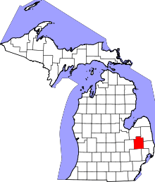 | |
| Villages | ||
| Townships | ||
| CDPs | ||
| Other unincorporated communities | ||
| Footnotes | ‡This populated place also has portions in an adjacent county or counties | |
Municipalities and communities of Tuscola County, Michigan, United States | ||
|---|---|---|
| Cities | 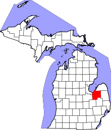 | |
| Villages | ||
| Charter township | ||
| General law townships | ||
| CDP | ||
| Other unincorporated communities | ||
| Footnotes | ‡This populated place also has portions in an adjacent county or counties | |