Sittard-Geleen
| Sittard-Geleen Zittert-Gelaen | ||
|---|---|---|
| Municipality | ||
|
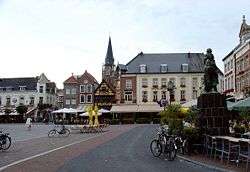
Sittard market square | ||
| ||
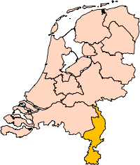
.svg.png) Location in Limburg | ||
| Coordinates: 51°0′N 5°52′E / 51.000°N 5.867°ECoordinates: 51°0′N 5°52′E / 51.000°N 5.867°E | ||
| Country | Netherlands | |
| Province | Limburg | |
| Established | 1 January 2001[1] | |
| Government[2] | ||
| • Body | Municipal council | |
| • Mayor | Sjraar Cox (PvdA) | |
| Area[3] | ||
| • Municipality | 80.53 km2 (31.09 sq mi) | |
| • Land | 79.02 km2 (30.51 sq mi) | |
| • Water | 1.51 km2 (0.58 sq mi) | |
| Elevation[4] | 47 m (154 ft) | |
| Highest elevation | 100 m (300 ft) | |
| Population (Municipality, May 2014; Urban and Metro, May 2014)[5][6] | ||
| • Municipality | 93,736 | |
| • Density | 1,186/km2 (3,070/sq mi) | |
| • Urban | 135,255 | |
| • Metro | 148,217 | |
| Time zone | CET (UTC+1) | |
| • Summer (DST) | CEST (UTC+2) | |
| Postcode | 6120–6167 | |
| Area code | 046 | |
| Website |
www | |

Sittard-Geleen (Dutch pronunciation: [ˌsɪtɑrt xəˈleːn];[7] Limburgish: Zittert-Gelaen) is a municipality in the southeastern Netherlands. It was formed in 2001 from the former municipalities Sittard, Geleen and Born.
The combined municipality has approximately 96,000 inhabitants (2007) and is thus the second most populated municipality in Limburg (after Maastricht with 125,000 inhabitants). Since the 2006 municipal elections, the city has been governed by a coalition of PvdA (Labour), GroenLinks (Green) and the local party GOB.
To the west, Sittard-Geleen borders on Belgium, while to the east, it borders on Germany.
Population centres
Born, Broeksittard, Buchten, Einighausen, Geleen, Graetheide, Grevenbicht, Guttecoven, Holtum, Limbricht, Munstergeleen, Windraak, Obbicht, Papenhoven, Schipperskerk and Sittard.
Topography
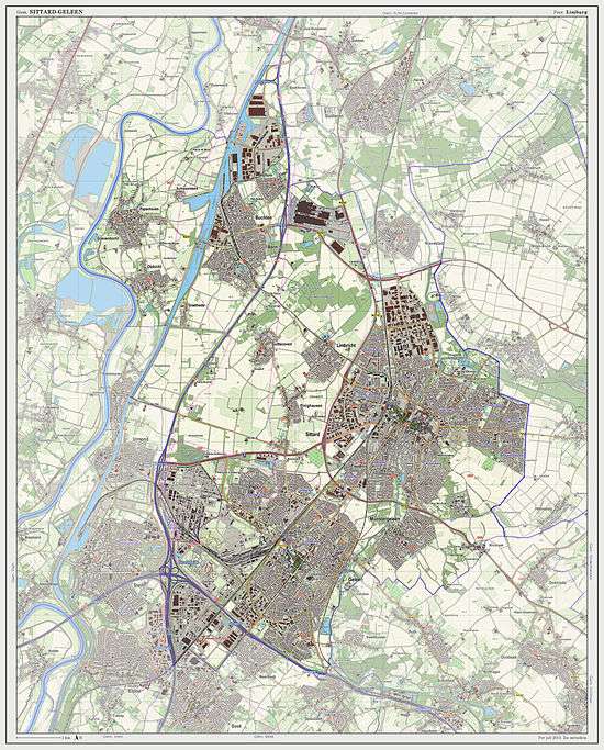
Dutch Topographic map of the municipality of Sittard-Geleen, 2013.
References
- ↑ "Gemeentelijke indeling op 1 januari 2001" [Municipal divisions on 1 January 2001]. cbs.nl (in Dutch). CBS. Retrieved 12 October 2013.
- ↑ "Burgemeester Sjraar Cox" [Mayor Sjraar Cox] (in Dutch). Gemeente Sittard-Geleen. Retrieved 12 October 2013.
- ↑ "Kerncijfers wijken en buurten" [Key figures for neighbourhoods]. CBS Statline (in Dutch). CBS. 2 July 2013. Retrieved 12 March 2014.
- ↑ "Postcodetool for 6131LB". Actueel Hoogtebestand Nederland (in Dutch). Het Waterschapshuis. Retrieved 12 October 2013.
- ↑ "Bevolkingsontwikkeling; regio per maand" [Population growth; regions per month]. CBS Statline (in Dutch). CBS. 26 June 2014. Retrieved 24 July 2014.
- ↑ "Bevolkingsontwikkeling; regio per maand" [Population growth; regions per month]. CBS Statline (in Dutch). CBS. 26 June 2014. Retrieved 24 July 2014.
- ↑ Geleen in isolation: [ɣəˈleːn].
External links
 Media related to Sittard-Geleen at Wikimedia Commons
- Official website
 |
Maaseik (BE-VLI) Meuse |
Echt-Susteren | | |
| Dilsen-Stokkem (BE-VLI) / Meuse | |
Selfkant (DE-NW) | ||
| ||||
| | ||||
| Stein | Beek | Schinnen |