St. Philip's Church Ruins
|
St. Philip's Church Ruins | |
 | |
  | |
| Location |
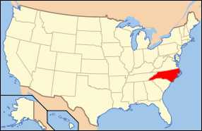
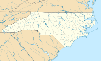
Smithville Township North Carolina United States |
|---|---|
| Coordinates | 34°2′32″N 77°56′55″W / 34.04222°N 77.94861°WCoordinates: 34°2′32″N 77°56′55″W / 34.04222°N 77.94861°W |
| Area | 8 acres (3.2 ha) |
| Built | 1754-1768 |
| Architect | Unknown |
| NRHP Reference # | 70000442[1] |
| Added to NRHP | February 26, 1970 |
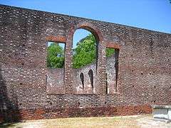
The St. Philip's Church Ruins are the remains of a colonial Anglican church building in Brunswick Town, North Carolina, United States.[2] The church is located beside the Cape Fear River in the Brunswick Town Historic District, along with Fort Anderson, Russelborough and the nearby Orton Plantation. Construction of St. Philip's Church lasted 14 years, but took only one day to be destroyed when the British Army burned Brunswick Town.[3] Before its demise, the building was considered one of the finest religious structures in the Province of North Carolina.[4] On February 26, 1970, the St. Philip's Church Ruins was added to the National Register of Historic Places.[5]
History
In 1741, the St. Philip's Parish was created in Brunswick Town with James Moir as the first vicar. It was the sister church of St. James Episcopal Church. Construction of St. Philip's Church began in 1754, but was not completed until 1768. The first minister to lead the new church was John Barnett and colonial governor Arthur Dobbs designated St. Philip's as "His Majesty’s Chapel in North Carolina." Barnett was succeeded by J. Cramp and Nicholas Christian. During the American Revolutionary War, the British Army attacked Brunswick Town and burned St. Philip's Church, Russelborough, and most of the homes and businesses. The church walls were the only parts of the structure not to be destroyed. Brunswick Town was deserted and the church remains were relatively untouched for almost a century.[6][7]
In March 1862, Confederate Army engineers began to survey the remains of Brunswick Town and St. Philip's Church. The Confederates built earthworks and trenches in the town, covering the remains of several burnt structures except for the church. The fort was constructed to protect the city of Wilmington 18 miles (29 km) upstream, a vital port during the Civil War. The bastion was named Fort St. Philip, but renamed Fort Anderson in July 1863.[8] During the attack on Fort Anderson in February 1865, cannonballs shot from Union ships in the Cape Fear River hit the walls of St. Philip's Church and are still evident today. When the Confederate forces were defeated, Union soldiers desecrated several graves at St. Philip's Church and removed the building's cornerstone. Confederate bodies were placed inside the church.[7][9]
In 1899, the newly formed Cape Fear Chapter of the North Carolina Society of The Colonial Dames of America visited the St. Philip's Church Ruins to pay homage to Revolutionary War casualties in Brunswick Town. In 1902, the chapter erected a marble plaque inside St. Philip's to commemorate Brunswick Town co-founder, Maurice Moore. Excavations at Brunswick Town began in 1958 and items such as bullets, buttons, and a cannonball were retrieved from inside the St. Philip's Church ruins. The church is now part of the Brunswick Town State historic site. Visitors may walk through the church and tour the earthworks of nearby Fort Anderson.[10][11]
Architecture
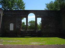
The St. Philip's Church Ruins consists of four brick walls, as well as graves located inside and outside of the church. The bricks used for construction were imported from England and the walls measure three feet (0.91 m) thick. The building is 76 feet six inches (23.3 m) long, 53 feet three inches (16.2 m) wide, and 24 feet four inches (7.4 m) high. The floor and roof were destroyed in the fire, as well as the three doors and eleven windows that measured fifteen by seven feet (4.6 m x 2.1 m). The church floor was made of wood, except for the aisles which featured one foot (0.3 m) square brick tiles that formed the shape of a cross. The pews were wooden and the Governor's pew was raised above the others. Twelve burial sites are located inside the church and there are several graves remaining outside of the structure that were not desecrated by Union troops.[7][12] Notable people buried at St. Philip's Church include Arthur Dobbs, Governor Benjamin Smith, and Supreme Court Associate Justice Alfred Moore.[13][14][15][16]
See also
References
- ↑ National Park Service (2010-07-09). "National Register Information System". National Register of Historic Places. National Park Service.
- ↑ "Brunswick Town/Fort Anderson". North Carolina Office of Archives and History. Retrieved 2008-05-11.
- ↑ Prose, Francine (1993-03-07). "A Sojourn On Cape Fear". New York Times. Retrieved 2008-05-11.
- ↑ Lossing, Benson (1860). "The Pictoral Field-book of the Revolution". Harper & Brothers: 362.
- ↑ "North Carolina - Brunswick County". National Register of Historic Places. Retrieved 2008-05-11.
- ↑ "History". St. Philip’s Episcopal Church. Retrieved 2015-12-08.
- 1 2 3 "St. Philip's Anglican Church". North Carolina Department of Cultural Resources. Retrieved 2008-05-11.
- ↑ Fonvielle, Chris (2001). The Wilmington Campaign: Last Departing Rays of Hope. Stackpole Books. pp. 29–30. ISBN 0-8117-2991-5.
- ↑ Fonvielle, Chris (1999). Fort Anderson: Battle for Wilmington. Da Capo Press. p. 93. ISBN 1-882810-24-4.
- ↑ South, Stanley (2005). An Archaeological Evolution. Springer. p. 108. ISBN 0-387-23401-2.
- ↑ Fonvielle, Chris (1999). Fort Anderson: Battle for Wilmington. Da Capo Press. pp. 93, 96. ISBN 1-882810-24-4.
- ↑ Haywood, Marshall (1903). "Governor William Tryon, and His Administration in the Province of North Carolina". E. M. Uzzell: 24.
- ↑ "St. Philips Church". Historical Marker Database. Retrieved 2008-05-11.
- ↑ "Arthur Dobbs (1689-1765)". North Carolina History Project. Retrieved 2008-05-11.
- ↑ "Brunswick County North Carolina". The Political Graveyard. Retrieved 2008-05-11.
- ↑ "Alfred Moore (1755-1810)". North Carolina History Project. Retrieved 2008-05-11.
External links
- Historic American Buildings Survey (HABS) No. NC-109, "St. Philip's Church (Ruins), State Route 1533, Boiling Spring Lakes, Brunswick County, NC", 2 data pages