Stannard Township, Michigan
| Stannard Township, Michigan | |
|---|---|
| Township | |
 Stannard Township, Michigan Location within the state of Michigan | |
| Coordinates: 46°33′36″N 89°8′49″W / 46.56000°N 89.14694°WCoordinates: 46°33′36″N 89°8′49″W / 46.56000°N 89.14694°W | |
| Country | United States |
| State | Michigan |
| County | Ontonagon |
| Area | |
| • Total | 125.1 sq mi (324.0 km2) |
| • Land | 125.1 sq mi (323.9 km2) |
| • Water | 0.0 sq mi (0.1 km2) |
| Elevation | 1,089 ft (332 m) |
| Population (2000) | |
| • Total | 833 |
| • Density | 6.7/sq mi (2.6/km2) |
| Time zone | Eastern (EST) (UTC-5) |
| • Summer (DST) | EDT (UTC-4) |
| FIPS code | 26-76180[1] |
| GNIS feature ID | 1627120[2] |
Stannard Township is a civil township of Ontonagon County, in the U.S. state of Michigan. The population was 833 at the 2000 census.
Communities
- Bruce Crossing is a small unincorporated community in the township.
- Paynesville is a small unincorporated community on M-28 and the Soo Line about three miles east of Bruce Crossing at 46°31′25″N 89°06′59″W / 46.52361°N 89.11639°W. It was named after the Payne family who owned homesteads nearby. It was a stop on the Duluth, South Shore and Atlantic Railway. On the SE corner, at the intersection of Blacksmith Rd and N Paynesville Road, in Paynesville, resides a historic Finnish Lutheran Church.
Geography
According to the United States Census Bureau, the township has a total area of 125.1 square miles (324 km2), of which 125.1 square miles (324 km2) is land and 0.04 square miles (0.10 km2) (0.02%) is water.
The western portion of the township is drained by the Baltimore River and its tributaries. The middle and eastern portions are drained, respectively, by the middle and east branches of the Ontonagon River.
Demographics
As of the census[1] of 2000, there were 833 people, 364 households, and 232 families residing in the township. The population density was 6.7 per square mile (2.6/km²). There were 518 housing units at an average density of 4.1 per square mile (1.6/km²). The racial makeup of the township was 98.20% White, 0.12% African American, 0.84% Native American, and 0.84% from two or more races. Hispanic or Latino of any race were 0.60% of the population. 55.6% were of Finnish, 9.5% German and 7.3% American ancestry according to Census 2000.
There were 364 households out of which 23.4% had children under the age of 18 living with them, 52.5% were married couples living together, 6.3% had a female householder with no husband present, and 36.0% were non-families. 31.3% of all households were made up of individuals and 16.2% had someone living alone who was 65 years of age or older. The average household size was 2.23 and the average family size was 2.80.
In the township the population was spread out with 20.6% under the age of 18, 4.3% from 18 to 24, 25.3% from 25 to 44, 26.8% from 45 to 64, and 22.9% who were 65 years of age or older. The median age was 45 years. For every 100 females there were 114.1 males. For every 100 females age 18 and over, there were 111.2 males.
The median income for a household in the township was $24,706, and the median income for a family was $30,938. Males had a median income of $27,708 versus $19,519 for females. The per capita income for the township was $14,327. About 8.3% of families and 14.6% of the population were below the poverty line, including 20.3% of those under age 18 and 11.1% of those age 65 or over.
References
Municipalities and communities of Ontonagon County, Michigan, United States | ||
|---|---|---|
| Village | 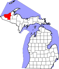 | |
| Townships | ||
| CDP | ||
| Other unincorporated communities | ||
| Ghost towns | ||