Stewarts Point, California
| Stewarts, California | |
|---|---|
| Unincorporated community | |
|
General Store | |
 Stewarts, California | |
| Coordinates: 38°39′07″N 123°23′57″W / 38.65194°N 123.39917°WCoordinates: 38°39′07″N 123°23′57″W / 38.65194°N 123.39917°W | |
| Country | United States |
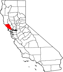
| State | California |
| County | Sonoma |
| Elevation | 108 ft (33 m) |
| Time zone | Pacific (PST) (UTC-8) |
| • Summer (DST) | PDT (UTC-7) |
| ZIP code | 95480 |
| Area code(s) | 707 |
| GNIS feature ID | 252807[1] |
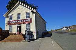
Stewarts Point is an unincorporated community in Sonoma County, California, United States. Stewarts Point is located on the Pacific coast and California State Route 1 20 miles (32 km) west of Healdsburg. Stewarts Point has a post office which was established in 1888.[2] The community is named after the Stewart family, who moved to the area in 1856.[3]
Stewarts Point is the home of the Kashia Band of Pomo Indians of the Stewarts Point Rancheria.
References
- ↑ U.S. Geological Survey Geographic Names Information System: Stewarts Point, California
- ↑ ZIP Code Lookup
- ↑ Durham, David L. (1998). California's Geographic Names: A Gazetteer of Historic and Modern Names of the State. Quill Driver Books. p. 707. ISBN 1-884995-14-4.
External links
![]() Media related to Stewarts Point at Wikimedia Commons
Media related to Stewarts Point at Wikimedia Commons
This article is issued from Wikipedia - version of the 10/29/2016. The text is available under the Creative Commons Attribution/Share Alike but additional terms may apply for the media files.