Sugarloaf Hill (Knockmealdowns)
| Sugarloaf Hill | |
|---|---|
| Cnoc na Binne | |
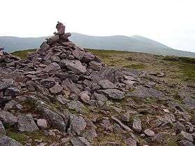 Summit cairn of Sugarloaf Hill | |
| Highest point | |
| Elevation | 663 m (2,175 ft) [1] |
| Prominence | 118 m (387 ft) |
| Listing | Hewitt |
| Geography | |
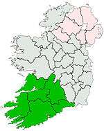
 Sugarloaf Hill Location in Ireland | |
| Location | County Tipperary / County Waterford, Ireland |
| Parent range | Knockmealdown Mountains |
| OSI/OSNI grid | S039105 |
| Topo map | OSi Discovery 74 |
Sugarloaf Hill (Irish: Cnoc na Binne) is a mountain peak located in the Knockmealdown Mountains on the border between County Tipperary and County Waterford.
See also
References
- ↑ Hiking in Ireland, Helen Fairbairn, Gareth Mc Cormack, Lonely Planet, 2010, see Googlwe books
Coordinates: 52°14′46″N 7°56′31″W / 52.246°N 7.942°W
This article is issued from Wikipedia - version of the 1/15/2016. The text is available under the Creative Commons Attribution/Share Alike but additional terms may apply for the media files.