Suwannee County, Florida
| Suwannee County, Florida | |
|---|---|
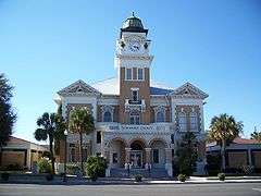 The Suwannee County Courthouse in Live Oak | |
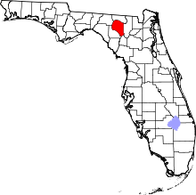 Location in the U.S. state of Florida | |
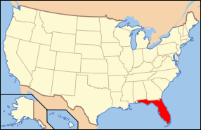 Florida's location in the U.S. | |
| Founded | December 21, 1858 |
| Named for | Suwannee River |
| Seat | Live Oak |
| Largest city | Live Oak |
| Area | |
| • Total | 692 sq mi (1,792 km2) |
| • Land | 689 sq mi (1,785 km2) |
| • Water | 3.7 sq mi (10 km2), 0.5% |
| Population (est.) | |
| • (2015) | 43,760 |
| • Density | 60/sq mi (23/km²) |
| Congressional district | 3rd |
| Time zone | Eastern: UTC-5/-4 |
| Website |
suwcounty |
Suwannee County is a county located in the state of Florida. As of the 2010 census, the population was 41,551.[1] Its county seat is Live Oak.[2] Suwannee County was a dry county until August 2011, when the sale of alcoholic beverages became legal in the county.[3]
History
Suwannee County was created in 1858,[4] as railways were constructed through the area connecting it to Jacksonville, Tallahassee, and points north. It was named after the Suwannee River, which forms the county's northern, western, and much of its southern border. The word "Suwannee" may either be a corruption of the Spanish San Juan ("Saint John") or from the Cherokee sawani ("echo river").
The rural areas supported numerous lumber and turpentine camps. In the 1930s, the anthropologist Zora Neale Hurston did research in North Florida timber camps.
Geography
According to the U.S. Census Bureau, the county has a total area of 692 square miles (1,790 km2), of which 689 square miles (1,780 km2) is land and 3.7 square miles (9.6 km2) (0.5%) is water.[5]
Adjacent counties
- Hamilton County - north
- Columbia County - east
- Gilchrist County - southeast
- Lafayette County - west
- Madison County - northwest
Demographics
| Historical population | |||
|---|---|---|---|
| Census | Pop. | %± | |
| 1860 | 2,303 | — | |
| 1870 | 3,556 | 54.4% | |
| 1880 | 7,161 | 101.4% | |
| 1890 | 10,524 | 47.0% | |
| 1900 | 14,554 | 38.3% | |
| 1910 | 18,603 | 27.8% | |
| 1920 | 19,789 | 6.4% | |
| 1930 | 15,731 | −20.5% | |
| 1940 | 17,073 | 8.5% | |
| 1950 | 16,986 | −0.5% | |
| 1960 | 14,961 | −11.9% | |
| 1970 | 15,559 | 4.0% | |
| 1980 | 22,287 | 43.2% | |
| 1990 | 26,780 | 20.2% | |
| 2000 | 34,844 | 30.1% | |
| 2010 | 41,551 | 19.2% | |
| Est. 2015 | 43,760 | [6] | 5.3% |
| U.S. Decennial Census[7] 1790-1960[8] 1900-1990[9] 1990-2000[10] 2010-2015[1] | |||
As of the census[11] of 2000, there were 34,844 people, 13,460 households, and 9,691 families residing in the county. The population density was 51 people per square mile (20/km²). There were 15,679 housing units at an average density of 23 per square mile (9/km²). The racial makeup of the county was 84.53% White, 12.11% Black or African American, 0.39% Native American, 0.51% Asian, 0.04% Pacific Islander, 1.12% from other races, and 1.29% from two or more races. 4.89% of the population were Hispanic or Latino of any race.
There were 13,460 households out of which 29.50% had children under the age of 18 living with them, 56.50% were married couples living together, 11.20% had a female householder with no husband present, and 28.00% were non-families. 23.30% of all households were made up of individuals and 11.00% had someone living alone who was 65 years of age or older. The average household size was 2.54 and the average family size was 2.96.
In the county the population was spread out with 24.00% under the age of 18, 8.50% from 18 to 24, 25.10% from 25 to 44, 25.40% from 45 to 64, and 16.90% who were 65 years of age or older. The median age was 40 years. For every 100 females there were 95.40 males. For every 100 females age 18 and over, there were 92.90 males.
The median income for a household in the county was $29,963, and the median income for a family was $34,032. Males had a median income of $26,256 versus $21,136 for females. The per capita income for the county was $14,678. About 14.80% of families and 18.50% of the population were below the poverty line, including 21.90% of those under age 18 and 12.40% of those age 65 or over.
In March 2016, the county's unemployment rate was 4.8%.
Libraries
Suwannee County is served by the Suwannee River Regional Library System, which contains 8 branches and also serves Hamilton and Madison counties.
- Branford
- Greenville
- Jasper
- Jennings
- Lee
- Live Oak
- Madison
- White Springs
Transportation
Airports
Suwannee County is accessed by air from Suwannee County Airport located just 2 miles west of Live Oak. It is a publicly operated airport run by the county government that has a paved runway in excess of 4,000 feet, major aircraft maintenance, training, car rental, as well as selling 100LL aviation fuel from a manned FBO. There are also many private airparks scattered throughout the county.
Railroads
Suwannee County has one surviving railroad line. The primary one is a CSX line formerly owned by the Seaboard Air Line Railroad that served Amtrak's Sunset Limited until it was truncated to New Orleans in 2005 by Hurricane Katrina. Union Depot and Atlantic Coast Line Freight Station was Suwannee County's premiere railroad station on the corner of US 129 & SR 136 in Live Oak, and served both the Atlantic Coast Line Railroad and Seaboard Air Line Railroad but has not been in use since the mid-20th Century. Various abandoned lines also exist within the county, one of which was converted into the Suwannee River Greenway Trail, along the southeastern part of the county.
Major roads
 Interstate 10 is the main interstate highway through Swuannee County, running west and east through the panhandle from Alabama to Jacksonville. Three interchanges exist in the county at US 90 east of Falmouth, (Exit 275), US 129 in Live Oak (Exit 283), and CR 137 north of Wellborn (Exit 292).
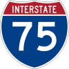 Interstate 75 also is an interstate highway, running south and north, but only in a remote area of eastern Suwannee County known as Pouchers Corner, and only has an interchange with SR 136 (Exit 439).
 US 27
US 27 US 90
US 90 US 129
 State Road 51
 State Road 136
 State Road 247
Communities
City
Town
Unincorporated communities
- Beachville
- Dickert
- Dowling Park
- Ellaville
- Falmouth
- Fort Union
- Hildreth
- Houston
- Luraville
- McAlpin
- O'Brien
- Padlock
- Pouchers Corner
- Rixford
- Slade
- Suwannee Springs
- Wellborn
See also
References
- 1 2 "State & County QuickFacts". United States Census Bureau. Retrieved February 15, 2014.
- ↑ "Find a County". National Association of Counties. Retrieved 2011-06-07.
- ↑ "Suwannee Votes Wet", Suwannee Democrat
- ↑ Publications of the Florida Historical Society. Florida Historical Society. 1908. p. 34.
- ↑ "US Gazetteer files: 2010, 2000, and 1990". United States Census Bureau. 2011-02-12. Retrieved 2011-04-23.
- ↑ "County Totals Dataset: Population, Population Change and Estimated Components of Population Change: April 1, 2010 to July 1, 2015". Retrieved July 2, 2016.
- ↑ "U.S. Decennial Census". United States Census Bureau. Retrieved June 16, 2014.
- ↑ "Historical Census Browser". University of Virginia Library. Retrieved June 16, 2014.
- ↑ "Population of Counties by Decennial Census: 1900 to 1990". United States Census Bureau. Retrieved June 16, 2014.
- ↑ "Census 2000 PHC-T-4. Ranking Tables for Counties: 1990 and 2000" (PDF). United States Census Bureau. Retrieved June 16, 2014.
- ↑ "American FactFinder". United States Census Bureau. Retrieved 2011-05-14.
External links
| Wikimedia Commons has media related to Suwannee County, Florida. |
Government links/Constitutional offices
- Suwannee County Board of County Commissioners
- Suwannee County Supervisor of Elections
- Suwannee County Property Appraiser
- Suwannee County Sheriff's Office
- Suwannee County Tax Collector
Special districts
Judicial branch
- Suwannee County Clerk of Courts
- Public Defender, 3rd Judicial Circuit of Florida serving Columbia, Dixie, Hamilton, Lafayette, Madison, Suwannee, and Taylor Counties
- Office of the State Attorney, 3rd Judicial Circuit of Florida
- Circuit and County Court for the 3rd Judicial Circuit of Florida
Tourism links
Environmental
 |
Madison County | Hamilton County | | |
| Lafayette County | |
Columbia County | ||
| ||||
| | ||||
| Gilchrist County |
Municipalities and communities of Suwannee County, Florida, United States | ||
|---|---|---|
| City | | |
| Town | ||
| Unincorporated communities | ||
Coordinates: 30°11′N 82°59′W / 30.19°N 82.99°W