Valderrama Province
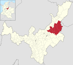
Location of the Valderrama Province in Boyacá Department
The Valderrama Province is a subregion of the Colombian Department of Boyacá. The subregion is formed by 7 municipalities.
It is geographically located within 112 04’ 00” East Longitude and within 10 57’ 00” North Latitude. The poblation lies in the elevation of 50 meters above sea level and the highest peak of Mt. Baloy northeast of the poblacion is 1900m.[1]
Municipalities
Betéitiva • Chita • Jericó • Paz de Río • Socotá • Socha • Tasco
References
External links
- (Spanish) Boyacá Info; Provinces of Boyacá
This article is issued from Wikipedia - version of the 9/17/2016. The text is available under the Creative Commons Attribution/Share Alike but additional terms may apply for the media files.