Vest-Agder
Coordinates: 58°34′59″N 7°34′59″E / 58.583°N 7.583°E
| Vest-Agder fylke | ||
|---|---|---|
| County | ||
 | ||
| ||
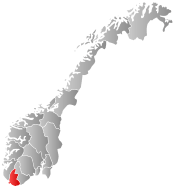 Vest-Agder within Norway | ||
| Country | Norway | |
| County | Vest-Agder | |
| Region | Sørlandet | |
| County ID | NO-10 | |
| Administrative centre | Kristiansand | |
| Government | ||
| • Governor |
Ann-Kristin Olsen (1998–present) | |
| • County mayor |
Thore Westermoen Kristelig Folkeparti (2003–present) | |
| Area | ||
| • Total | 7,276 km2 (2,809 sq mi) | |
| • Land | 6,677 km2 (2,578 sq mi) | |
| Area rank | #15 in Norway, 2.19% of Norway's land area | |
| Population (2014) | ||
| • Total | 177.906 | |
| • Rank | 14 (3.50% of country) | |
| • Density | 24/km2 (60/sq mi) | |
| • Change (10 years) | 7.8 % | |
| Demonym(s) | Vestegde | |
| Time zone | CET (UTC+01) | |
| • Summer (DST) | CEST (UTC+02) | |
| Official language form | Neutral | |
| Income (per capita) | 137,000 NOK | |
| GDP (per capita) | 219,928 NOK (2001) | |
| GDP national rank | 14 (2.27% of country) | |
| Website | www.vaf.no | |
|
| ||
Vest-Agder [ˈvɛst ˈɑɡdər] (![]() listen) (West Agder) is a county in Norway, bordering Rogaland to the west and Aust-Agder to the east. In 2002 there were 157,851 inhabitants, which is 3.4% of the total population in Norway. Its area is 7,281 km2 (2,811 sq mi). The county administration, and largest city is Kristiansand
listen) (West Agder) is a county in Norway, bordering Rogaland to the west and Aust-Agder to the east. In 2002 there were 157,851 inhabitants, which is 3.4% of the total population in Norway. Its area is 7,281 km2 (2,811 sq mi). The county administration, and largest city is Kristiansand
Shipping, commerce and recreation are the main industries here. Compared to other counties of Norway, Vest-Agder is noted for having the highest level of foreign exports. Another international dimension linked to the county is the large-scale emigration to North America that took place from the 1850s and onwards, which resulted in many Americans returning to the county after Norway became prosperous. This feature is particularly predominant in Kvinesdal and Farsund, which maintains strong cultural links with the United States.
General information
Name
The meaning of the name is "(the) western (part of) Agder". See also: Aust-Agder
Lister og Mandal amt was created on 1 January 1662 and it consisted of the two old lens of Lister and Mandal. This name continued until 1 January 1919, when the name was changed to Vest-Agder.
Coat-of-arms
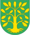
The coat-of-arms is from modern times. They were granted on 12 December 1958. They show an oak tree in yellow on a green background, representing the rich nature in the area.[1]
Geography

Vest-Agder is the southernmost county in Norway, extending inland from the North Sea and its arm, the Skagerrak, to the southern fringes of Setesdalen, surrounded by the mountain range Setesdalsheiene. It includes the southernmost point of the entire country, Pysen island south of Mandal, and the southernmost part of continental Norway, Lindesnes. It has a very broken and hilly surface. From the coast there are six valleys that stretch north into the county: Audnedalen, Lyngdalen, Kvinesdalen, Mandalen, Sirdalen, and Otradalen (which continues into Aust-Agder where it is called Setesdalen).
Most of the habitation lies along the coast, including the towns Kristiansand, Mandal, Flekkefjord, and Farsund. About 31 fjords are located there. The northern portion is mountainous and sparsely settled, while the central upland moors are used for pasturing of cattle and sheep. Since the Gulf Stream touches the coast of Vest-Agder, it is also called "the Norwegian Riviera", and Agder as a whole is also called "The California of Norway".
History
| Historical population | ||
|---|---|---|
| Year | Pop. | ±% |
| 1951 | 96,942 | — |
| 1961 | 109,083 | +12.5% |
| 1971 | 124,171 | +13.8% |
| 1981 | 136,718 | +10.1% |
| 1991 | 145,091 | +6.1% |
| 2001 | 156,878 | +8.1% |
| 2011 | 172,408 | +9.9% |
| 2021? | 197,664 | +14.6% |
| 2031? | 219,898 | +11.2% |
| Source: Statistics Norway.[2] | ||
In the 16th century, Dutch merchant vessels began to visit ports in southern Norway to purchase salmon and other goods. Soon thereafter the export of timber began, as oak from southern Norway was exceptionally well suited for shipbuilding. As the Netherlands developed in the 17th century, it began to suffer from a severe labor shortage, and many families from Vest-Agder and Aust-Agder emigrated to the Netherlands, especially the coastal areas.
In the 19th century, emigration to the United States started. One of the most important causes of this emigration was the emergence of steamships. While Vest-Agder and Aust-Agder had historically had very strong positions in the manufacture and repair of sailing ships, the change to steam resulted in very hard times for this industry. Emigration to the United States was a means of escaping from the high unemployment that followed.[5]
Municipalities
On 1 January 1838, all the counties were divided into local administrative units each with their own governments (see formannskapsdistrikt). The number and borders of these municipalities were based on the parishes of the Church of Norway. Over time the number and locations of these have changed, and at present there are 15 municipalities in Vest-Agder. The municipality of Åseral was part of the neighboring county of Nedenes until 1880, when it was moved to Vest-Agder.[6]
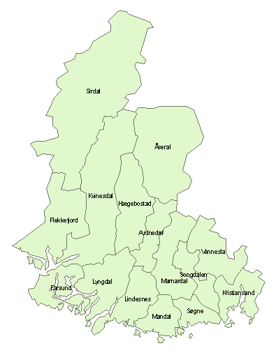
| Rank | Name | Inhabitants | Area km² |
|---|---|---|---|
| 1 | |
90,000 | 261 |
| 2 | |
14,696 | 212 |
| 3 | |
13,116 | 363 |
| 4 | |
12,509 | 144 |
| 5 | |
9,310 | 252 |
| 6 | |
9,003 | 482 |
| 7 | |
7,739 | 372 |
| 8 | |
5,940 | 207 |
| 9 | |
5,776 | 893 |
| 10 | |
4,661 | 299 |
| 11 | |
2,231 | 379 |
| 12 | |
1,790 | 1,555 |
| 13 | |
1,670 | 251 |
| 14 | |
1,624 | 426 |
| 15 | |
917 | 801 |
| Total | Vest-Agder | 182,377 | 7,281 |
See also
References
- ↑ "Kommunevåpen". Flags of the World. 28 June 2002. Retrieved 28 September 2008. External link in
|publisher=(help) - ↑ Projected population - Statistics Norway
- ↑ Statistics Norway - Church of Norway.
- ↑ Statistics Norway - Members of religious and life stance communities outside the Church of Norway, by religion/life stance. County. 2006-2010 Archived November 2, 2011, at the Wayback Machine.
- ↑ Follesdal, John. "Vest-Agder genealogy resources". Ancestry.com. Retrieved 2009-12-15.
- ↑ Jukvam, Dag (1999). "Historisk oversikt over endringer i kommune- og fylkesinndelingen" (PDF) (in Norwegian). Statistisk sentralbyrå.
External links
-
 Media related to Vest-Agder at Wikimedia Commons
 -
 Vest-Agder travel guide from Wikivoyage
 - Vest-Agder fylkeskommune (Norwegian)
- Vest-Agder: Norway’s southernmost county
| Counties | ||
|---|---|---|
| Cities | ||
| Towns | ||
| Municipalities | ||