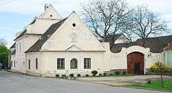
Vratěnín
| Vratěnín | |||
|---|---|---|---|
| Municipality | |||
 | |||
| |||
 Vratěnín | |||
| Coordinates: 48°54′17″N 15°35′23″E / 48.90472°N 15.58972°ECoordinates: 48°54′17″N 15°35′23″E / 48.90472°N 15.58972°E | |||
| Country |
| ||
| Region | South Moravian | ||
| District | Znojmo | ||
| Area | |||
| • Total | 14.72 km2 (5.68 sq mi) | ||
| Elevation | 468 m (1,535 ft) | ||
| Population (21.1.2012) | |||
| • Total | 294 | ||
| • Density | 20/km2 (52/sq mi) | ||
| Postal code | 671 07 | ||
Vratěnín is a village and municipality (obec) in Znojmo District in the South Moravian Region of the Czech Republic.
The municipality covers an area of 14.72 square kilometres (5.68 sq mi), and has a population of 282 (as at 2 October 2006).
Vratěnín lies approximately 34 kilometres (21 mi) west of Znojmo, 82 km (51 mi) south-west of Brno, and 157 km (98 mi) south-east of Prague.
References
| Wikimedia Commons has media related to Vratěnín. |
This article is issued from Wikipedia - version of the 8/24/2016. The text is available under the Creative Commons Attribution/Share Alike but additional terms may apply for the media files.