Walhalla, South Carolina
| Walhalla, South Carolina | |
|---|---|
| City | |
 Location in Oconee County and the state of South Carolina. | |
| Coordinates: 34°46′2″N 83°3′52″W / 34.76722°N 83.06444°WCoordinates: 34°46′2″N 83°3′52″W / 34.76722°N 83.06444°W | |
| Country | United States |
| State | South Carolina |
| County | Oconee |
| Area | |
| • Total | 3.8 sq mi (9.7 km2) |
| • Land | 3.7 sq mi (9.6 km2) |
| • Water | 0.0 sq mi (0.1 km2) |
| Elevation | 1,033 ft (315 m) |
| Population (2000) | |
| • Total | 3,801 |
| • Density | 1,023.8/sq mi (395.3/km2) |
| Time zone | Eastern (EST) (UTC-5) |
| • Summer (DST) | EDT (UTC-4) |
| ZIP code | 29691 |
| Area code(s) | 864 |
| FIPS code | 45-74095[1] |
| GNIS feature ID | 1230451[2] |
| Website | Walhalla, South Carolina |
Walhalla is a small town in the foothills of the Blue Ridge Mountains in Oconee County, South Carolina, United States. It is located 16 miles (26 km) from Clemson University in Clemson, South Carolina. It is the home to the world famous Steak House restaurant, a cafeteria style eatery which doesn't serve steak, but is famous because of its chicken. It lies within the area of the Blue Ridge Escarpment, and area of transition between mountains and piedmont, and contains numerous waterfalls. It was founded by German settlers in the late 1800's even though the area had long been settled by Scotch-Irish farmers. The population was 3,801 at the 2000 census. It is the county seat of Oconee County.[3] The current mayor of Walhalla is Danny Edwards.[4]
History
Walhalla began as a settlement of German immigrants who left from Hamburg, Germany and Bavaria with some English, Scots and Irish who came over in the same ship. In particular, General John A. Wagener, Claus Bullwinkel, John C. Henckel, Jacob Schroder, and Christopher F. Seeba (trustees of the German Colonization Society of Charleston) bought 17,859 acres (72.27 km2) of land for $27,000 from Reverend Joseph Grisham of West Union on December 24, 1849.[5]
The Ellicott Rock, Keil Farm, Oconee County Cage, Oconee Station and Richards House, St. John's Lutheran Church, Stumphouse Tunnel Complex, and Walhalla Graded School are listed on the National Register of Historic Places.[6]
Geography and climate
Walhalla is located at 34°46′2″N 83°3′52″W / 34.76722°N 83.06444°W (34.767263, -83.064321).[7]
According to the United States Census Bureau, the city has a total area of 3.8 square miles (9.8 km2), of which, 3.7 square miles (9.6 km2) of it is land and 0.1 square miles (0.26 km2) of it (1.33%) is water.
The town is built mostly on types of granite rock. It is also near some minor faults and therefore subject to small and infrequent earthquakes. The last nearby earthquake had its epicenter in Newry, South Carolina, and occurred at 7:42 am EDT on May 19, 1971.[8] The earthquake had an intensity of VI (Strong) in Newry as measured by the Mercalli intensity scale. The cause of the Newry quake was likely a slippage of the Brevard Fault and other faults in the area aided by the immense weight of the man-made Lake Keowee, created by the Keowee Dam.
The Stumphouse Mountain Tunnel is located near Walhalla. Walhalla is a Germanic term referring to the 'hall' where warriors would go if selected to fight during Ragnarok.
| Climate data for Walhalla, South Carolina, normals 1981–2010, extremes 1896-present | |||||||||||||
|---|---|---|---|---|---|---|---|---|---|---|---|---|---|
| Month | Jan | Feb | Mar | Apr | May | Jun | Jul | Aug | Sep | Oct | Nov | Dec | Year |
| Record high °F (°C) | 81 (27) |
82 (28) |
94 (34) |
94 (34) |
101 (38) |
105 (41) |
106 (41) |
106 (41) |
108 (42) |
98 (37) |
87 (31) |
81 (27) |
108 (42) |
| Average high °F (°C) | 52.3 (11.3) |
56.3 (13.5) |
64.0 (17.8) |
72.5 (22.5) |
79.8 (26.6) |
86.5 (30.3) |
89.4 (31.9) |
88.3 (31.3) |
82.4 (28) |
72.6 (22.6) |
63.5 (17.5) |
53.8 (12.1) |
71.78 (22.12) |
| Average low °F (°C) | 28.6 (−1.9) |
30.8 (−0.7) |
36.8 (2.7) |
44.2 (6.8) |
54.0 (12.2) |
62.6 (17) |
65.9 (18.8) |
65.9 (18.8) |
59.1 (15.1) |
47.5 (8.6) |
37.6 (3.1) |
30.8 (−0.7) |
46.98 (8.32) |
| Record low °F (°C) | −5 (−21) |
−4 (−20) |
3 (−16) |
20 (−7) |
28 (−2) |
39 (4) |
49 (9) |
49 (9) |
32 (0) |
20 (−7) |
9 (−13) |
−3 (−19) |
−5 (−21) |
| Average precipitation inches (mm) | 4.97 (126.2) |
4.90 (124.5) |
5.10 (129.5) |
3.93 (99.8) |
4.53 (115.1) |
4.78 (121.4) |
5.09 (129.3) |
5.45 (138.4) |
5.03 (127.8) |
4.22 (107.2) |
4.63 (117.6) |
5.18 (131.6) |
57.81 (1,468.4) |
| Average snowfall inches (cm) | 1.6 (4.1) |
0.8 (2) |
0.4 (1) |
0 (0) |
0 (0) |
0 (0) |
0 (0) |
0 (0) |
0 (0) |
0 (0) |
0 (0) |
0.3 (0.8) |
3.1 (7.9) |
| Source: NOAA[9] | |||||||||||||
Demographics
| Historical population | |||
|---|---|---|---|
| Census | Pop. | %± | |
| 1870 | 716 | — | |
| 1880 | 789 | 10.2% | |
| 1890 | 820 | 3.9% | |
| 1900 | 1,307 | 59.4% | |
| 1910 | 1,595 | 22.0% | |
| 1920 | 2,068 | 29.7% | |
| 1930 | 2,388 | 15.5% | |
| 1940 | 2,820 | 18.1% | |
| 1950 | 3,104 | 10.1% | |
| 1960 | 3,431 | 10.5% | |
| 1970 | 3,662 | 6.7% | |
| 1980 | 3,977 | 8.6% | |
| 1990 | 3,755 | −5.6% | |
| 2000 | 3,801 | 1.2% | |
| 2010 | 4,263 | 12.2% | |
| Est. 2015 | 4,251 | [10] | −0.3% |
As of the census[1] of 2000, there were 3,801 people, 1,558 households, and 1,028 families residing in the city. The population density was 1,023.8 people per square mile (395.6/km²). There were 1,705 housing units at an average density of 459.2 per square mile (177.4/km²). The racial makeup of the city was 83.19% White, 15.35% Hispanic (of any race), 6.92% African American, 0.32% Native American, 0.32% Asian, 0.18% Pacific Islander, 1.42% from two or more races, and 7.66% other races.
There were 1,558 households out of which 30.9% had children under the age of 18 living with them, 45.2% were married couples living together, 16.7% had a female householder with no husband present, and 34.0% were non-families. 30.9% of all households were made up of individuals and 15.6% had someone living alone who was 65 years of age or older. The average household size was 2.40 and the average family size was 2.98.
In the city the population was spread out with 25.7% under the age of 18, 8.3% from 18 to 24, 27.7% from 25 to 44, 22.5% from 45 to 64, and 15.7% who were 65 years of age or older. The median age was 36 years. For every 100 females there were 91.6 males. For every 100 females age 18 and over, there were 82.8 males.
The median income for a household in the city was $29,063, and the median income for a family was $34,184. Males had a median income of $28,445 versus $21,106 for females. The per capita income for the city was $15,691. About 14.1% of families and 17.2% of the population were below the poverty line, including 21.2% of those under age 18 and 15.0% of those age 65 or over.
Oktoberfest
Due to its German heritage, Walhalla is also known for its annual Oktoberfest celebration, which begins on the third Friday of October each year. The festival takes on Main Street in Walhalla (Hwy 28) and on the city's Sertoma Field, located between the high school and downtown (Hwy 183). The festival includes art and craft vendors, music, dancing, specialty food vendors, Carnival rides, and other festive activities.
References
- 1 2 "American FactFinder". United States Census Bureau. Retrieved 2008-01-31.
- ↑ "US Board on Geographic Names". United States Geological Survey. 2007-10-25. Retrieved 2008-01-31.
- ↑ "Find a County". National Association of Counties. Retrieved 2011-06-07.
- ↑ "Mayor - City of Walhalla". City of Walhalla. Retrieved 2012-05-24.
- ↑ "The History of Walhalla". South Carolina Information Highway. Retrieved 2007-12-19.
- ↑ National Park Service (2010-07-09). "National Register Information System". National Register of Historic Places. National Park Service.
- ↑ "US Gazetteer files: 2010, 2000, and 1990". United States Census Bureau. 2011-02-12. Retrieved 2011-04-23.
- ↑ "South Carolina Earthquake History". USGS. Retrieved 2007-12-19.
- ↑ "NowData – NOAA Online Weather Data". National Oceanic and Atmospheric Administration. Retrieved 2016-06-17.
- ↑ "Annual Estimates of the Resident Population for Incorporated Places: April 1, 2010 to July 1, 2015". Retrieved July 2, 2016.
- ↑ "Census of Population and Housing". Census.gov. Retrieved June 4, 2015.
External links
| Wikimedia Commons has media related to Walhalla, South Carolina. |
Municipalities and communities of Oconee County, South Carolina, United States | ||
|---|---|---|
| Cities | 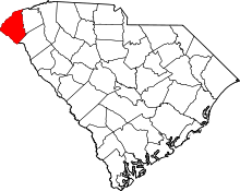 | |
| Towns | ||
| CDPs | ||
| Unincorporated communities | ||
| Ghost towns | ||