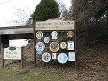
Seneca, South Carolina
| Seneca, South Carolina | |
|---|---|
| Town | |
| Motto: City of Smiles, City with Style | |
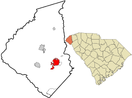 Location in Oconee County and the state of South Carolina. | |
| Coordinates: 34°41′3″N 82°57′21″W / 34.68417°N 82.95583°WCoordinates: 34°41′3″N 82°57′21″W / 34.68417°N 82.95583°W | |
| Country | United States |
| State | South Carolina |
| County | Oconee |
| Government | |
| • Mayor | Daniel W. Alexander |
| Area | |
| • Total | 7.1 sq mi (18.4 km2) |
| • Land | 7.1 sq mi (18.3 km2) |
| • Water | 0.0 sq mi (0.1 km2) |
| Elevation | 965 ft (294 m) |
| Population (2010)[1] | |
| • Total | 8,102 |
| • Density | 1,084.6/sq mi (418.8/km2) |
| Time zone | Eastern (EST) (UTC-5) |
| • Summer (DST) | EDT (UTC-4) |
| ZIP codes | 29672, 29678, 29679 |
| Area code(s) | 864 |
| FIPS code | 45-65095[2] |
| GNIS feature ID | 1250833[3] |
| Website | http://www.seneca.sc.us/ |
Seneca is a city in Oconee County, South Carolina, United States. The population was 8,102 at the 2010 census. It is the principal city of the Seneca Micropolitan Statistical Area (population 74,273 at the 2010 census), an (MSA) which includes all of Oconee County and which is further included in the greater Greenville-Spartanburg-Anderson, South Carolina Combined Statistical Area (population 1,266,995 at the 2010 census).
The Democratic Vice-Presidential candidate for 2004, former United States Senator from North Carolina, John Edwards, was born in Seneca. It was named for the nearby Cherokee town of Isunigu, known to the English as "Seneca Town".
History
Seneca was founded as Seneca City and named for a nearby Native American village and the Seneca River. The town was located at the intersection of the Blue Ridge Railroad and the newly built Atlanta and Charlotte Air Line Railroad. Both lines are now part of the Norfolk Southern Railway. A. W. Thompson and J. J. Norton, who were locating engineers for the Air Line Railroad, purchased the land from Col. Brown of Anderson, South Carolina. A stake marking the center of town was driven into the intersection of the railroad tracks and the current Townville Street. The land was divided into lots for one-half mile from the stake. An auction was held on August 14, 1873. The town was given a charter by the state legislature on March 14, 1874. In 1908, the name was changed to Seneca.
Seneca developed as a marketing and shipping point for cotton. During the harvest, wagons bringing cotton would line up for blocks from the railroad station. A passenger terminal, several hotels, and a park were built near the railroad tracks. Recently, this park was named the Norton-Thompson Park in honor of its founders.
The first school was built in 1874. The community was the home of the Seneca Institute - Seneca Junior College, which was an African-American school from 1899 to 1939.
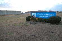
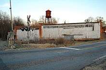
Textile mills came into the area with the construction of a plant-and-mill village by the Courtenay Manufacturing Company in Newry on the Little River in 1893. W.L. Jordon built another textile plant and mill village east of Seneca. This village has been called Jordania, Londsdale, and Utica as the ownership of the plant changed. The J. P. Stevens Plant, which was later called the Westpoint Stevens Plant, was a large integrated textile mill built on Lake Hartwell. Many other textile mills came to the area. These plants were the main industry for Seneca for the first half of the twentieth century. Nearly all these textile plants have been closed.
With the construction of Lake Hartwell in 1963, Lake Keowee in 1971, and Lake Jocassee in 1974, Seneca and the area saw dramatic changes. The Oconee Nuclear Station was built on Lake Keowee. The recreation provided by the lakes and other attractions such as nearby Clemson University brought many retirees from other parts of the country. Retirement communities have been built in the area.[4][5]
Historical Districts
In an around Seneca, there are a number of historic buildings and districts that are on the National Register of Historic Places:
- Seneca Historic District
Seneca Historic District was listed in 1974. It is located south of the railroad tracks. The district consists of a number of homes and three churches that were built in the late nineteenth and early twentieth centuries. The houses have architectural styles that were popular in the period. It also includes a log cabin from the mid nineteenth century that was moved from Long Creek, South Carolina. The South Carolina Department of Archives and History has additional pictures and information,[6] copies of the nomination forms,[7][8] and a map of the district.[9]
- Ram Cat Alley Historic District was listed in 2000. It is a twenty-one building commercial district built in the 1880s to the 1930s. The name of the street came from cats that gathered around a meat market. Many of these buildings have been rejuvenated and now house restaurants, shops, and professional offices. The South Carolina Department of Archives and History has additional pictures and information,[10] a copy of the nomination form,[11] and a map.[12]
- Newry, South Carolina:Newry Historic District was listed in 1982. It is a historic textile mill village near Seneca. The South Carolina Department of Archives and History has additional pictures and information,[13] a copy of the nomination form,[14] and a map.[15]
Also listed on the National Register of Historic Places are the: Alexander-Hill House, Faith Cabin Library at Seneca Junior College, McPhail Angus Farm, and Old Pickens Presbyterian Church.[16]
Geography
Seneca is located at 34°41′3″N 82°57′21″W / 34.68417°N 82.95583°W (34.684145, -82.955778).[17]
According to the United States Census Bureau, the city has a total area of 7.1 square miles (18 km2), of which, 7.1 square miles (18 km2) of it is land and 0.04 square miles (0.10 km2) of it (0.56%) is water.
Demographics
| Historical population | |||
|---|---|---|---|
| Census | Pop. | %± | |
| 1880 | 382 | — | |
| 1900 | 920 | — | |
| 1910 | 1,313 | 42.7% | |
| 1920 | 1,460 | 11.2% | |
| 1930 | 1,929 | 32.1% | |
| 1940 | 2,155 | 11.7% | |
| 1950 | 3,649 | 69.3% | |
| 1960 | 5,227 | 43.2% | |
| 1970 | 6,027 | 15.3% | |
| 1980 | 7,436 | 23.4% | |
| 1990 | 7,726 | 3.9% | |
| 2000 | 7,652 | −1.0% | |
| 2010 | 8,102 | 5.9% | |
| Est. 2015 | 8,279 | [18] | 2.2% |
| U.S. Decennial Census 2011 estimate | |||
As of the census[2] of 2000, there were 7,652 people, 3,286 households, and 2,096 families residing in the city. The population density was 1,084.6 people per square mile (418.5/km²). There were 3,677 housing units at an average density of 521.2 per square mile (201.1/km²). The racial makeup of the city was 63.32% White, 33.77% African American, 0.31% Native American, 0.63% Asian, 0.01% Pacific Islander, 0.65% from other races, and 1.31% from two or more races. Hispanic or Latino of any race were 1.53% of the population.
There were 3,286 households out of which 27.4% had children under the age of 18 living with them, 42.2% were married couples living together, 17.5% had a female householder with no husband present, and 36.2% were non-families. Of all households 32.3% were made up of individuals and 13.2% had someone living alone who was 65 years of age or older. The average household size was 2.32 and the average family size was 2.93.
In the city the population was spread out with 24.4% under the age of 18, 9.5% from 18 to 24, 25.3% from 25 to 44, 24.7% from 45 to 64, and 16.0% who were 65 years of age or older. The median age was 38 years. For every 100 females there were 87.5 males. For every 100 females age 18 and over, there were 83.0 males.
The median income for a household in the city was $32,643, and the median income for a family was $44,487. Males had a median income of $31,381 versus $21,472 for females. The per capita income for the city was $18,498. About 13.0% of families and 15.6% of the population were below the poverty line, including 23.0% of those under age 18 and 16.4% of those age 65 or over.
Government
- Seneca City Hall is located on North First Street, in the center of the historic (downtown) area of Seneca. North First Street is also Highway 123 Business. The City Hall Complex is also the location of the Seneca Police Dept, Seneca Light and Water, as well as the offices of the Mayor and City Administrator.
- Seneca Fire Department is housed on West South Fourth Street, in a new complex. The Fire House is just across the street from the Shaver Complex that houses the Shaver Civic Center, and the sports fields for the Seneca Recreation Department, as well as a park for smaller children, and a rubberized soft walking track. The City of Seneca also owns and operates a public pool located on North Fairplay Street.
Notable people
- Willie Aikens, Major League Baseball
- Steven T. Wright, author
- Bennie Cunningham, National Football League
- Needtobreathe, Christian rock band
- John Edwards, politician
- Clarence Kay, National Football League
- Marshall Parker, politician
- Carter H. Anderson, pilot
- Todd Chrisley, public figure
- Lindsey Graham, United States Senator from South Carolina [19]
References
- ↑ "2010 Census Redistricting Data (Public Law 94-171) Summary File". American FactFinder. United States Census Bureau. Retrieved 4 August 2012.
- 1 2 "American FactFinder". United States Census Bureau. Retrieved 2008-01-31.
- ↑ "US Board on Geographic Names". United States Geological Survey. 2007-10-25. Retrieved 2008-01-31.
- ↑ Louise Matheson Bell, Seneca: Visions of Yesterday, 2003, ISBN 0-9763843-0-2.
- ↑ Edgar, Walter, ed. The South Carolina Encyclopedia, University of South Carolina Press, 2006, p. 859, ISBN 1-57003-598-9.
- ↑ Pictures of the Seneca Historic District
- ↑ Seneca Historic District nomination form I
- ↑ Seneca Historic District nomination form II
- ↑ Map of Seneca Historic District
- ↑ Pictures of the Ram Cat Alley Historic District
- ↑ Ram Cat Alley Historic District nomination form
- ↑ Map of the Ram Cat Alley Historic District
- ↑ Pictures of the Newry Historic District
- ↑ Newry Historic District nomination form
- ↑ Map of the Newry Historic District
- ↑ National Park Service (2010-07-09). "National Register Information System". National Register of Historic Places. National Park Service.
- ↑ "US Gazetteer files: 2010, 2000, and 1990". United States Census Bureau. 2011-02-12. Retrieved 2011-04-23.
- ↑ "Annual Estimates of the Resident Population for Incorporated Places: April 1, 2010 to July 1, 2015". Retrieved July 2, 2016.
- ↑ "United States Senator Lindsey Graham, South Carolina : Biography". Lgraham.senate.gov. Retrieved May 8, 2016.
External links
- City of Seneca official website
- Oconee County Chamber of Commerce
- Seneca High School
- Oconee School District website
- Oconee County Library
- Video tour of Seneca from 1906
Municipalities and communities of Oconee County, South Carolina, United States | ||
|---|---|---|
| Cities | 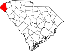 | |
| Towns | ||
| CDPs | ||
| Unincorporated communities | ||
| Ghost towns | ||