West Atchafalaya Floodway
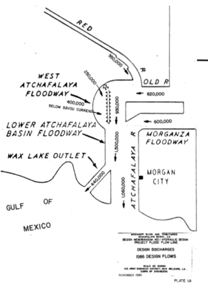
The West Atchafalaya Floodway is a flood control structure of the Mississippi River and Tributaries Project located in the Lower Atchafalaya Basin in south-central Louisiana. It has a project design flood flow capacity of 250,000 cu ft/s (7,100 m3/s).[1]
Atchafalaya Basin floodways
The Atchafalaya Basin system comprises three floodways. Two of these, the West Atchafalaya Floodway and the Morganza Floodway, are at the northern end. Together with the Atchafalaya River, these floodways are designed to pass flood waters into the third component, the Lower Atchafalaya Basin Floodway, which is 833,000 acres (3,370 km2) in size and is bounded on the north by U.S. Route 190, on the east and west by the Atchafalaya Basin protection levees, and on the south by the Gulf of Mexico.[2] Farther downstream, floodwaters enter the Gulf of Mexico through the Atchafalaya River below Morgan City, Louisiana and the Wax Lake Outlet.[3]
See also
References
- ↑ "The Mississippi River & Tributaries Project: Designing the Project Flood" (PDF), United States Army Corps of Engineers (PDF), April 2008, retrieved 2011-05-16
- ↑ "Lower Atchafalaya Basin Floodway System". Team New Orleans. United States Army Corps of Engineers. Retrieved 2011-05-27.
- ↑ "The Atcharalaya Basin Project" (PDF), United States Army Corps of Engineers (PDF), retrieved 2011-05-27
Coordinates: 30°45′40″N 91°52′08″W / 30.7610°N 91.8690°W