Willoughby Hills, Ohio
| Willoughby Hills, Ohio | |
|---|---|
| City | |
|
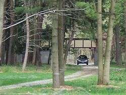
The Louis Penfield House, designed by Frank Lloyd Wright | |
| Nickname(s): The Bridge City | |
| Motto: Where The City Meets The Country | |
 Location in Ohio | |
 Location of Willoughby Hills in Lake County | |
| Coordinates: 41°35′17″N 81°26′33″W / 41.58806°N 81.44250°WCoordinates: 41°35′17″N 81°26′33″W / 41.58806°N 81.44250°W | |
| Country | United States |
| State | Ohio |
| County | Lake |
| Founded | 1815[1] |
| Incorporated | 1954 |
| Government | |
| • Mayor | Robert Weger (R)[2] |
| Area[3] | |
| • Total | 10.82 sq mi (28.02 km2) |
| • Land | 10.73 sq mi (27.79 km2) |
| • Water | 0.09 sq mi (0.23 km2) |
| Elevation | 804 ft (244 m) |
| Population (2010)[4] | |
| • Total | 9,485 |
| • Estimate (2012[5]) | 9,457 |
| • Density | 884.0/sq mi (341.3/km2) |
| Time zone | EST (UTC-5) |
| • Summer (DST) | EDT (UTC-4) |
| ZIP code | 44092 and 44094 |
| Area code(s) | 440 |
| FIPS code | 39-85512[6] |
| GNIS feature ID | 1056575[7] |
| Website | http://www.WilloughbyHills-OH.gov |
Willoughby Hills is a city in Lake County, Ohio, United States. The population was 9,485 at the 2010 census.
Geography
Willoughby Hills is located at 41°35′17″N 81°26′33″W / 41.58806°N 81.44250°W (41.588151, -81.442475).[8]
According to the United States Census Bureau, the city has a total area of 10.82 square miles (28.02 km2), of which 10.73 square miles (27.79 km2) is land and 0.09 square miles (0.23 km2) is water.[3] Willoughby Hills borders Euclid and Richmond Heights on the west, Gates Mills, Highland Heights, and Mayfield Village on the south, Kirtland and Waite Hill on the east, and Wickliffe and Willoughby to the north.
Demographics
| Historical population | |||
|---|---|---|---|
| Census | Pop. | %± | |
| 1960 | 4,241 | — | |
| 1970 | 5,969 | 40.7% | |
| 1980 | 8,612 | 44.3% | |
| 1990 | 8,427 | −2.1% | |
| 2000 | 8,595 | 2.0% | |
| 2010 | 9,485 | 10.4% | |
| Est. 2015 | 9,382 | [9] | −1.1% |
| Sources:[10][11][6][12] | |||
88.3% spoke English, 3.7% Slovene, 3.1% Croatian, 1.1% Spanish, 1.1% Italian, and 1.1% Russian.[13]
Of the city's population over the age of 25, 35.5% held a bachelor's degree or higher.[14]
2010 census
As of the census[4] of 2010, there were 9,485 people, 4,398 households, and 2,602 families residing in the city. The population density was 884.0 inhabitants per square mile (341.3/km2). There were 4,929 housing units at an average density of 459.4 per square mile (177.4/km2). The racial makeup of the city was 77.6% White, 16.1% African American, 4.3% Asian, 0.3% from other races, and 1.6% from two or more races. Hispanic or Latino of any race were 1.3% of the population.
There were 4,398 households of which 23.0% had children under the age of 18 living with them, 44.6% were married couples living together, 10.4% had a female householder with no husband present, 4.1% had a male householder with no wife present, and 40.8% were non-families. 35.6% of all households were made up of individuals and 10.8% had someone living alone who was 65 years of age or older. The average household size was 2.16 and the average family size was 2.80.
The median age in the city was 44.4 years. 18.6% of residents were under the age of 18; 8.2% were between the ages of 18 and 24; 24% were from 25 to 44; 31.1% were from 45 to 64; and 18.1% were 65 years of age or older. The gender makeup of the city was 48.1% male and 51.9% female.
2000 census
As of the census[6] of 2000, there were 8,595 people, 3,973 households, and 2,379 families residing in the city. The population density was 798.4 people per square mile (308.4/km²). There were 4,292 housing units at an average density of 398.7 per square mile (154.0/km²). The racial makeup of the city was 88.84% White, 6.47% African American, 0.07% Native American, 3.55% Asian, 0.15% from other races, and 0.92% from two or more races. Hispanic or Latino of any race were 0.70% of the population. 15.5% were of German, 15.3% Italian, 11.1% Slovene, 8.8% Irish and 7.3% English ancestry according to Census 2000.
There were 3,973 households out of which 20.9% had children under the age of 18 living with them, 49.2% were married couples living together, 7.4% had a female householder with no husband present, and 40.1% were non-families. 35.1% of all households were made up of individuals and 11.5% had someone living alone who was 65 years of age or older. The average household size was 2.16 and the average family size was 2.82.
In the city the population was spread out with 18.1% under the age of 18, 7.1% from 18 to 24, 28.4% from 25 to 44, 27.9% from 45 to 64, and 18.4% who were 65 years of age or older. The median age was 43 years. For every 100 females there were 91.5 males. For every 100 females age 18 and over, there were 90.0 males.
The median income for a household in the city was $47,493, and the median income for a family was $60,397. Males had a median income of $47,190 versus $30,908 for females. The per capita income for the city was $26,688. About 1.7% of families and 3.4% of the population were below the poverty line, including 2.7% of those under age 18 and 2.7% of those age 65 or over.
Education
- Willoughby Hills is part of the Willoughby-Eastlake City School District.
- Willoughby Hills is served by a branch of the Willoughby-Eastlake Public Library.
Sites of interest
Two notable buildings in Willoughby Hills are the Squire's Castle in the Cleveland Metroparks' North Chagrin Reservation and the Louis Penfield House, a house designed by Frank Lloyd Wright.
Notable person
- Carl Gaertner- artist/painter
References
- ↑ http://www.willoughbyhills-oh.gov/about_us/history/index.php
- ↑ "Robert Weger, candidate for Willoughby Hills mayor, November 2015 election". The News-Herald. 19 October 2015. Retrieved 31 January 2016.
- 1 2 "US Gazetteer files 2010". United States Census Bureau. Retrieved 2013-01-06.
- 1 2 "American FactFinder". United States Census Bureau. Retrieved 2013-01-06.
- ↑ "Population Estimates". United States Census Bureau. Retrieved 2013-06-17.
- 1 2 3 "American FactFinder". United States Census Bureau. Retrieved 2008-01-31.
- ↑ "US Board on Geographic Names". United States Geological Survey. 2007-10-25. Retrieved 2008-01-31.
- ↑ "US Gazetteer files: 2010, 2000, and 1990". United States Census Bureau. 2011-02-12. Retrieved 2011-04-23.
- ↑ "Annual Estimates of the Resident Population for Incorporated Places: April 1, 2010 to July 1, 2015". Retrieved July 2, 2016.
- ↑ "Number of Inhabitants: Ohio" (PDF). 18th Census of the United States. U.S. Census Bureau. Retrieved 22 November 2013.
- ↑ "Ohio: Population and Housing Unit Counts" (PDF). U.S. Census Bureau. Retrieved 22 November 2013.
- ↑ "Incorporated Places and Minor Civil Divisions Datasets: Subcounty Population Estimates: April 1, 2010 to July 1, 2012". U.S. Census Bureau. Retrieved 25 November 2013.
- ↑ http://www.mla.org/map_data_results&state_id=39&place_id=85512&cty_id=
- ↑ http://quickfacts.census.gov/qfd/states/39/3985512.html
External links
Municipalities and communities of Lake County, Ohio, United States | ||
|---|---|---|
| Cities |  | |
| Villages | ||
| Townships | ||
| CDP | ||
| Unincorporated communities | ||