Willowick, Ohio
| Willowick, Ohio | |
|---|---|
| City | |
|
Lake Erie shoreline looking west from Lakefront Lodge Metropark | |
| Motto: "Great Living on a Great Lake" | |
 Location of Willowick, Ohio | |
 Location of Willowick in Lake County | |
| Coordinates: 41°38′6″N 81°28′6″W / 41.63500°N 81.46833°WCoordinates: 41°38′6″N 81°28′6″W / 41.63500°N 81.46833°W | |
| Country |
|
| State |
|
| County | Lake |
| Government | |
| • Mayor | Rich Regovich |
| Area[1] | |
| • Total | 2.54 sq mi (6.58 km2) |
| • Land | 2.54 sq mi (6.58 km2) |
| • Water | 0 sq mi (0 km2) |
| Elevation[2] | 620 ft (189 m) |
| Population (2010)[3] | |
| • Total | 14,171 |
| • Estimate (2012[4]) | 14,082 |
| • Density | 5,579.1/sq mi (2,154.1/km2) |
| Time zone | Eastern (EST) (UTC-5) |
| • Summer (DST) | EDT (UTC-4) |
| ZIP codes | 44092, 44094, 44095 |
| Area code(s) | 440 |
| FIPS code | 39-85638[5] |
| GNIS feature ID | 1049332[2] |
| Website | http://www.cityofwillowick.com/ |

Willowick is a city in Lake County, Ohio, United States. The population was 14,171 at the 2010 census. A suburb of Cleveland, Willowick is served by a branch of the Willoughby-Eastlake Public Library. The city's name is a portmanteau of two adjacent cities in Lake County: Willoughby and Wickliffe. The current mayor of Willowick is Rich Regovich. Residents can be informed about city issues and important dates via the Willowick Community Channel available on Public-access television cable TV.
Geography
Willowick is located at 41°38′6″N 81°28′6″W / 41.63500°N 81.46833°W (41.635080, -81.468290).[6]
According to the United States Census Bureau, the city has a total area of 2.54 square miles (6.58 km2), all land.[1]
Demographics
94% spoke English, 1.9% Croatian, 1.0% Slovene, and 1.0% Spanish.[7]
| Historical population | |||
|---|---|---|---|
| Census | Pop. | %± | |
| 1930 | 667 | — | |
| 1940 | 915 | 37.2% | |
| 1950 | 3,677 | 301.9% | |
| 1960 | 18,749 | 409.9% | |
| 1970 | 21,237 | 13.3% | |
| 1980 | 17,758 | −16.4% | |
| 1990 | 15,269 | −14.0% | |
| 2000 | 14,361 | −5.9% | |
| 2010 | 14,171 | −1.3% | |
| Est. 2015 | 13,957 | [8] | −1.5% |
| Sources:[9][10][11][5][12] | |||
2010 census
As of the census[3] of 2010, there were 14,171 people, 6,110 households, and 3,859 families residing in the city. The population density was 5,579.1 inhabitants per square mile (2,154.1/km2). There were 6,476 housing units at an average density of 2,549.6 per square mile (984.4/km2). The racial makeup of the city was 95.0% White, 2.5% African American, 0.1% Native American, 0.8% Asian, 0.2% from other races, and 1.3% from two or more races. Hispanic or Latino of any race were 1.3% of the population.
There were 6,110 households of which 27.5% had children under the age of 18 living with them, 45.0% were married couples living together, 13.0% had a female householder with no husband present, 5.2% had a male householder with no wife present, and 36.8% were non-families. 31.2% of all households were made up of individuals and 14.2% had someone living alone who was 65 years of age or older. The average household size was 2.32 and the average family size was 2.91.
The median age in the city was 41.5 years. 20.9% of residents were under the age of 18; 7.4% were between the ages of 18 and 24; 26.5% were from 25 to 44; 26.2% were from 45 to 64; and 19.1% were 65 years of age or older. The gender makeup of the city was 48.4% male and 51.6% female.
2000 census
As of the census[5] of 2000, there were 14,361 people, 6,101 households, and 4,112 families residing in the city. The population density was 5,709.2 people per square mile (2,200.3/km²). There were 6,272 housing units at an average density of 2,493.4 per square mile (961.0/km²). The racial makeup of the city was 97.85% White, 0.75% African American, 0.05% Native American, 0.61% Asian, 0.03% from other races, and 0.71% from two or more races. Hispanic or Latino of any race were 0.71% of the population. 18.7% were of Italian, 16.0% German, 12.5% Irish, 9.3% Polish and 7.9% Slovene ancestry according to Census 2000.
There are 6,101 households. 25.4% of the households have children under the age of 18 living with them, 52.5% were married couples living together, 11.1% had a female householder with no husband present, and 32.6% were non-families. 28.3% of all households were made up of individuals non-familial related and 14.2% had someone living alone who was 65 years of age or older. The average household size was 2.35 and the average family size was 2.90.
The city's age population is spread out with 21.2% under the age of 18, 6.3% aged 18 to 24, 29.4% aged 25 to 44, 21.2% aged 45 to 64, and 21.9% who were 65 years of age or older. The median age was 41 years. For every 100 females there were 91.8 males. For every 100 females aged 18 and over, there are 87.2 males.
The median income per household in the city is $44,107 and the median income for a family was $52,675. Males had a median income of $38,966 versus $27,297 for females. The per capita income for the city was $22,053. About 3.2% of families and 4.5% of the population were below the poverty line, including 6.6% of those under age 18 and 4.9% of those age 65 or over.
Notable people
- Tom Bukovac, American session musician
- Mike Golic, football player and radio host
- Robert Manry, sailed across the Atlantic Ocean in the Tinkerbelle
Gallery
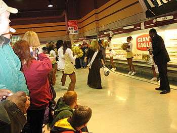 Miss Ohio 2006 bowls a turkey in Willowick, Ohio
References
- 1 2 "US Gazetteer files 2010". United States Census Bureau. Retrieved 2013-01-06.
- 1 2 "US Board on Geographic Names". United States Geological Survey. 2007-10-25. Retrieved 2008-01-31.
- 1 2 "American FactFinder". United States Census Bureau. Retrieved 2013-01-06.
- ↑ "Population Estimates". United States Census Bureau. Retrieved 2013-06-17.
- 1 2 3 "American FactFinder". United States Census Bureau. Retrieved 2008-01-31.
- ↑ "US Gazetteer files: 2010, 2000, and 1990". United States Census Bureau. 2011-02-12. Retrieved 2011-04-23.
- ↑ https://www.mla.org/cgi-shl/docstudio/docs.pl?map_data_results
- ↑ "Annual Estimates of the Resident Population for Incorporated Places: April 1, 2010 to July 1, 2015". Retrieved July 2, 2016.
- ↑ "Population: Ohio" (PDF). 1930 US Census. U.S. Census Bureau. Retrieved 28 November 2013.
- ↑ "Number of Inhabitants: Ohio" (PDF). 18th Census of the United States. U.S. Census Bureau. Retrieved 22 November 2013.
- ↑ "Ohio: Population and Housing Unit Counts" (PDF). U.S. Census Bureau. Retrieved 22 November 2013.
- ↑ "Incorporated Places and Minor Civil Divisions Datasets: Subcounty Population Estimates: April 1, 2010 to July 1, 2012". U.S. Census Bureau. Retrieved 25 November 2013.
External links
- Willoughby-Eastlake Public Library
- The History of Willowick, Ohio at the Wayback Machine (archived April 23, 2013)
- The History of Willowick, Ohio as Compiled by Gale Lippucci
Municipalities and communities of Lake County, Ohio, United States | ||
|---|---|---|
| Cities | 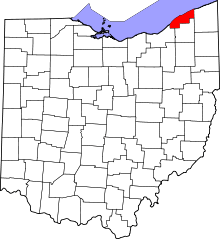 | |
| Villages | ||
| Townships | ||
| CDP | ||
| Unincorporated communities | ||