York, Western Australia
| York Western Australia | |||||||
|---|---|---|---|---|---|---|---|
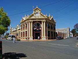 York Town Hall | |||||||
 York | |||||||
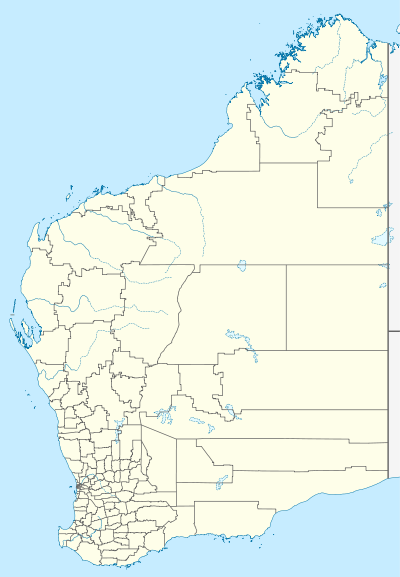
| Coordinates | 31°53′18.4″S 116°46′6.6″E / 31.888444°S 116.768500°ECoordinates: 31°53′18.4″S 116°46′6.6″E / 31.888444°S 116.768500°E | ||||||
| Population | 2,387 (2011 census)[1] | ||||||
| Established | 1835[2][3] | ||||||
| Postcode(s) | 6302 | ||||||
| Elevation | 179 m (587 ft) | ||||||
| Location | 96 km (60 mi) E of Perth | ||||||
| LGA(s) | Shire of York | ||||||
| State electorate(s) | Central Wheatbelt | ||||||
| Federal Division(s) | Pearce | ||||||
| |||||||
York is the oldest inland town in Western Australia, situated 97 kilometres (60 mi) east of Perth, and is the seat of the Shire of York. The York district and town taking its name from York County, Western Australia (in turn named after Prince Frederick, Duke of York and Albany), was first settled in 1831, two years after Perth was settled in 1829. A town was established in 1835 with the release of town allotments and the first buildings were erected in 1836.
History

With the increasing population of the Swan River Settlement in 1830, it became evident that suitable land would have to be discovered for the growing of crops needed to provide necessary food.
Ensign Robert Dale, a 20-year-old officer of the 63rd Regiment, led a small party in the first exploratory journey over the Darling Range during the winter months of 1830, into what was later to become known as the Avon Valley.[5][6]
As a result, Lieutenant-Governor Stirling decided that the new district should be thrown open for selection and this was done by Government Notice on 11 November 1830. By December 1830, 250,000 acres had been allotted, and in January 1831, 80,000 acres. Before the end of 1831 a further 6,030 acres in small lots had been taken up.[7]
In September 1831 Dale escorted the first party of settlers to the district, reaching the Avon valley on 16 September. They immediately set about the construction of huts, the preparation required for their stock and the cultivation of new land. Dale proposed an area two miles south of the summit of Mt Bakewell as the site for a future town to serve the district.[8]
In September 1833 a garrison of eight troops of the 21st North British Fusiliers was stationed at York.[9][10] Rules and regulations for the assignment of town allotments at York were gazetted in September 1834 and allotments were advertised for sale from July 1835.[2][11]
A township did not begin to appear until 1836. In July 1836 York comprised two houses, a barn, an army barracks and some out-houses, with about 50 acres of cleared land.[7]
The first decade of settlement in the Avon Valley showed steady progress and a clear indication that the whole district should develop into a rich and prosperous farming area. Following the discovery of gold in the Yilgarn in 1887, the town was teeming with miners, all alighting from the train and preparing to make the long journey across the plains to the goldfields.
Heritage Buildings
York has many important heritage buildings, some dating from the 1850s and 1860s, and many from the Gold Rush period (1885 to 1900). The entire town site of York has been listed as an Historic Town on the Register of the National Estate of the Commonwealth of Australia.
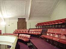
Many of York's older homes and buildings have now been restored and, while some have retained their original use, some others have been adaptively re-used with success. The Victorian Georgian style Resident Magistrate's House, one of the oldest houses in York (dating from the 1840s) now houses the Residency Museum. York churches include the Victorian Romanesque style Holy Trinity Anglican Church (completed in 1854); St Patrick's Roman Catholic Church (designed in the Gothic Revival style by the convict architect Joseph Nunan and completed in 1886); and the York Uniting Church constructed of local granite in the Gothic style (1888). The 19th century Western Australia Government Architect, George Temple Poole, designed a number of York's heritage buildings, namely the Federation Arts and Crafts style Post and Telegraph Office (1893); the Courthouse (c. 1896); the Federation Arts and Crafts style York Hospital (opened in 1896); and the 19th century portion of York Primary School: all are on the State Heritage Register. Other Gold Rush buildings include: the railway station buildings, now a museum (built in 1885); the York Roller Flour Mill, a major source of employment, at the entrance to York (1892); and the Victorian Filigree style Imperial Hotel (built in 1886 to accommodate the gold miners). Among early 20th century buildings are the Federation Free Classical style Town Hall (designed by Wright, Powell and Cameron and built in 1911), and the Federation Filigree style Castle Hotel (c.1905).
- Gallery of some Heritage Buildings in York
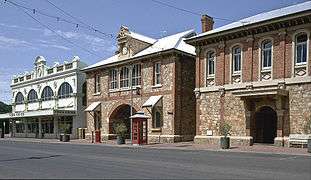 Co-op, Post Office, Courthouse
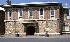 York Courthouse
 Imperial Inn and Town Hall
 York Railway Station
 York Hospital
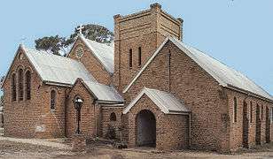 Anglican Church of the Holy Trinity
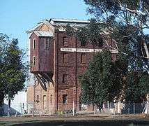 York Flour Mill
Climate
York is in a temperate climate zone and experiences distinctly dry (and hot) summers[12] and cool, wet winters.[13] Under the Köppen climate classification, York has a Mediterranean climate.
Climate data has been recorded by the Bureau of Meteorology at York Post Office from 1877 to 1996,[14] and another site from 1996 onwards.[15]
At the post office site, the mean annual daily maximum temperature is 24.7 °C (76.5 °F) and the mean annual daily minimum temperature is 10.5 °C (50.9 °F).[14] The hottest month is January with a mean maximum temperature of 33.6 °C (92.5 °F), while the coolest month is July with a mean minimum temperature of 5.3 °C (41.5 °F).[14] Mean temperatures are based on data from 1880 to 1996.[14] York has a mean annual rainfall of 449.8 millimetres (17.71 in).[14] The wettest month is June with 87.9 millimetres (3.46 in) and the driest is January with 9.5 millimetres (0.37 in).[14]
A severe thunderstorm lashed the town and surrounding areas on 27 January 2011, resulting in roofs being ripped off, trees being uprooted and power lines being brought down.[16] About 40 houses were damaged in the town as a result of the storm but no injuries were reported.[17]
| Climate data for York and York Post Office (averages: 1880–1996; extremes: 1934–2016) | |||||||||||||
|---|---|---|---|---|---|---|---|---|---|---|---|---|---|
| Month | Jan | Feb | Mar | Apr | May | Jun | Jul | Aug | Sep | Oct | Nov | Dec | Year |
| Record high °C (°F) | 46.6 (115.9) |
47.4 (117.3) |
43.4 (110.1) |
39.0 (102.2) |
34.4 (93.9) |
25.6 (78.1) |
25.4 (77.7) |
27.9 (82.2) |
33.7 (92.7) |
40.0 (104) |
42.3 (108.1) |
45.5 (113.9) |
47.4 (117.3) |
| Average high °C (°F) | 33.6 (92.5) |
32.9 (91.2) |
30.0 (86) |
25.5 (77.9) |
20.6 (69.1) |
17.4 (63.3) |
16.4 (61.5) |
17.5 (63.5) |
20.1 (68.2) |
23.4 (74.1) |
27.9 (82.2) |
31.5 (88.7) |
24.7 (76.5) |
| Average low °C (°F) | 16.6 (61.9) |
16.7 (62.1) |
14.8 (58.6) |
11.3 (52.3) |
8.0 (46.4) |
6.4 (43.5) |
5.3 (41.5) |
5.4 (41.7) |
6.5 (43.7) |
8.4 (47.1) |
12.0 (53.6) |
14.9 (58.8) |
10.5 (50.9) |
| Record low °C (°F) | 7.4 (45.3) |
6.8 (44.2) |
3.2 (37.8) |
0.6 (33.1) |
−3.2 (26.2) |
−4.0 (24.8) |
−5.2 (22.6) |
−3.0 (26.6) |
−2.2 (28) |
0.0 (32) |
0.4 (32.7) |
2.7 (36.9) |
−5.2 (22.6) |
| Average rainfall mm (inches) | 9.5 (0.374) |
14.6 (0.575) |
16.8 (0.661) |
24.1 (0.949) |
60.5 (2.382) |
87.9 (3.461) |
85.5 (3.366) |
65.9 (2.594) |
37.4 (1.472) |
25.5 (1.004) |
12.6 (0.496) |
10.1 (0.398) |
450.4 (17.732) |
| Average rainy days (≥ 0.2mm) | 1.4 | 2.2 | 2.7 | 5.8 | 9.9 | 14.6 | 15.3 | 13.1 | 10.0 | 6.4 | 4.2 | 2.1 | 87.7 |
| Source: Bureau of Meteorology[14][15] | |||||||||||||
Facilities and Attractions
The town has adapted by changing from a traditional sheep and wheat agricultural community into a tourist town. It features music festivals, a motor museum, art galleries, recreational facilities including skydiving and paragliding, many bed and breakfast services and the picturesque Avon River. The town population in 2010 was approximately 3800 and increasing 4% annually.
York is well serviced with all essential facilities, including York District High School for students from kindergarten to Year 10. The York Visitor Centre is located in the Town Hall. The York Community Resource Centre enables access to tertiary education. There is a 24/7 medical service, the York District Hospital, library, and swimming pool.
References
- ↑ Australian Bureau of Statistics (31 October 2012). "York (Urban Centre/Locality)". 2011 Census QuickStats. Retrieved 2 November 2012.
- 1 2 "Government Notice". The Perth Gazette and Western Australian Journal. 11 July 1835. p. 526. Retrieved 22 January 2016.
- ↑ "Perth Surrounds". State Heritage Office. Government of Western Australia. 10 June 2013. Retrieved 22 January 2016.
- ↑ St. Patrick's Catholic Church, York, Western Australia," Medievalism in Australian Cultural Memory, accessed 19 August 2013.
- ↑ Dale, Robert (1833). "Journal of an Expedition under the direction of Ensign Dale, to the Eastward of the Darling Mountains; in August, 1831". Journals of Several Expeditions Made in Western Australia During the Years 1829, 1830, 1831 and 1832: Under the Sanction of the Governor, Sir James Stirling. London: Joseph Cross. pp. 51–61. Retrieved 23 January 2016.
- ↑ Dale, Robert (1833). "Journal of another Expedition to the Eastward if the Darling Range, under the direction of Ensign Dale; commenced on the 25th of October, and concluded on the 7th of November, 1830". Journals of Several Expeditions Made in Western Australia During the Years 1829, 1830, 1831 and 1832: Under the Sanction of the Governor, Sir James Stirling. London: Joseph Cross. pp. 51–61. Retrieved 23 January 2016.
- 1 2 Hasluck, Paul ("Polygon") (12 September 1931). "Centenary of York - The First Inland Settlement". The West Australian. p. 4. Retrieved 23 January 2016.
- ↑ Dale, Robert (1833). "Letters from Mr. Dale, giving a summary description of the country passed over in going to Mount Bakewell, and, also, in an Expedition to examine the Country to the North and South of that place". Journals of Several Expeditions Made in Western Australia During the Years 1829, 1830, 1831 and 1832: Under the Sanction of the Governor, Sir James Stirling. London: Joseph Cross. pp. 155–160. Retrieved 23 January 2016.
- ↑ "The Western Australian Journal". The Perth Gazette and Western Australian Journal. 21 September 1833. p. 150. Retrieved 23 January 2016.
- ↑ "Government Notice". The Perth Gazette and Western Australian Journal. 12 October 1833. p. 161. Retrieved 23 January 2016.
- ↑ "Government Notice". The Perth Gazette and Western Australian Journal. 20 September 1834. p. 357. Retrieved 23 January 2016.
- ↑ "Australian Climatic Zones – All Climate Classes(Map)". Bureau of Meteorology website. Bureau of Meteorology. Archived from the original on 5 August 2009. Retrieved 8 May 2010.
- ↑ "Australian Climatic Zones (Map)". Bureau of Meteorology website. Bureau of Meteorology. Archived from the original on 2 September 2013. Retrieved 8 May 2010.
- 1 2 3 4 5 6 7 "Monthly Climate Statistics for Australian Locations – York Post Office". Bureau of Meteorology website. Bureau of Meteorology. Retrieved 3 December 2016.
- 1 2 "Monthly Climate Statistics for Australian Locations – York Post Office". Bureau of Meteorology website. Bureau of Meteorology. Retrieved 3 December 2016.
- ↑ "Wheatbelt towns lashed by thunderstorms, but cyclone warning cancelled". The Sunday Times. 28 January 2011. Retrieved 24 April 2011.
- ↑ "Houses damaged in trail of destruction across WA". The West Australian. 31 January 2011. Retrieved 24 April 2011.
External links
| Wikivoyage has a travel guide for York (Western Australia). |
![]() Media related to York, Western Australia at Wikimedia Commons
Media related to York, Western Australia at Wikimedia Commons