Álvaro Obregón, Michoacán
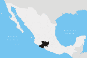
Álvaro Obregón is located in the center zone of the Mexican state of Michoacán. This town limits with the state of Guanajuato to the north, with Querendaro and Indaparapeo to the east, with Charo to the south, with Tarimbaro to the west and with Cuitzeo to the northwest. It is also home to Morelia's International Airport (Aeropuerto Internacional General Francisco J. Mujica).[1]
Demographics
It has a total of 19,502 people. Its ethnic population is about 49 people, 31 men and 18 women and their principal languages are Huichol and Purepecha. Its education structure is formed by preschool, high school and secondary education.[1]
History
This town was founded between 1760 and 1770 by people who lived in other towns like Singuio. This town is named Álvaro Obregón in honor of assassinated Revolutionary General and subsequent President Álvaro Obregón.[2]
Geography
Its territorial size is 162.64 km2 and it represents 0.35% of Michoacán.[2]
Its weather is temperate with rains in summer. It has important mountains and valleys like Cuitzeo, lomas de Purisimio, Quirio, Tzentzenguaro, and its principal river is rio Grande.[2]
Climate
| Climate data for Álvaro Obregón | |||||||||||||
|---|---|---|---|---|---|---|---|---|---|---|---|---|---|
| Month | Jan | Feb | Mar | Apr | May | Jun | Jul | Aug | Sep | Oct | Nov | Dec | Year |
| Average high °C (°F) | 22.5 (72.5) |
23.5 (74.3) |
26 (78.8) |
26.6 (79.9) |
26.8 (80.2) |
25.4 (77.7) |
24.1 (75.4) |
23.8 (74.8) |
23.7 (74.7) |
23.5 (74.3) |
23.2 (73.8) |
22.7 (72.9) |
24.3 (75.7) |
| Average low °C (°F) | 3.1 (37.6) |
4 (39) |
6.2 (43.2) |
8.1 (46.6) |
9.7 (49.5) |
11 (51.8) |
10.7 (51.3) |
10.7 (51.3) |
10.6 (51.1) |
8.7 (47.7) |
5.4 (41.7) |
3.7 (38.7) |
7.7 (45.9) |
| Average precipitation mm (inches) | 8 (0.3) |
5 (0.2) |
8 (0.3) |
18 (0.7) |
66 (2.6) |
150 (5.9) |
198 (7.8) |
175 (6.9) |
160 (6.3) |
71 (2.8) |
5 (0.2) |
5 (0.2) |
871 (34.3) |
| Source: Weatherbase [3] | |||||||||||||
Transportation
General Francisco J. Mujica International Airport is located in Álvaro Obregón.[4]
Economy
The main economic activity performed in the town is agriculture.[1]
They mainly seed corn, wheat, alfalfa, sargo and chickpea.[2]
Notable sites/buildings
- Templo de San Bartolo, Templo Espiritual de las Tres Ponencias y Palacio Municipal.
- Ex hacienda de San Bartolo.
- Ex hacienda de Quirio.
- Ex hacienda de Tzintzimeo.
- Ex hacienda de Palo Blanco.[2]
References
- 1 2 3 http://municipios.com.mx/michoacan/mexico/mexico-16.html. Michoacan/ 2008-01-27
- 1 2 3 4 5 http://e-local-gob.mx/work/tamplates/enciclo/michoacan/municipios/16003a.htm Municipios/2008-01-27
- ↑ "Weatherbase: Historical Weather for Álvaro Obregón, Distrito Federal". Weatherbase. 2011. Retrieved on November 24, 2011.
- ↑ "DIRECTORIO DE OFICINAS DE VENTAS." Aeromar. 4/7. Retrieved on December 18, 2010.
Coordinates: 19°49′26″N 101°02′24″W / 19.8238°N 101.0400°W